Župa dubrovačka
| Župa dubrovačka | |
|---|---|
| Municipality | |
| Općina Župa dubrovačka | |
 | |
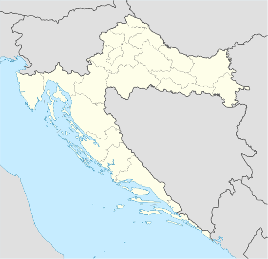 Župa dubrovačka Location of Župa dubrovačka in Croatia | |
| Coordinates: 42°37′N 18°11′E / 42.617°N 18.183°ECoordinates: 42°37′N 18°11′E / 42.617°N 18.183°E | |
| Country | Croatia |
| County | Dubrovnik–Neretva |
| Government | |
| • Municipal mayor | Silvio Nardelli |
| Area | |
| • Total | 22.81 km2 (8.81 sq mi) |
| Population (2001) | |
| • Total | 8,331 |
| • Density | 370/km2 (950/sq mi) |
| Time zone | CET (UTC+1) |
| • Summer (DST) | CEST (UTC+2) |
| Postal code | 20207 |
| Area code(s) | 020 |
Župa dubrovačka is a valley, a group of towns and a municipality of Dubrovnik-Neretva County in south-eastern Croatia. It has 6,663 inhabitants, 93% of which are Croats.
Župa dubrovačka stretches between Dubrovnik, the old Ragusa in the west and Cavtat, the ancient Epidaurus in the east, between the settlements of Dubac and Plat. The three islands Supetar, Mrkan and Bobara anchored right in front of the bay protect it from the open sea and from the north the hilly slopes of the Upper Župa. Tourist resorts are clustered along the coast.
Subdivisions of Dubrovnik-Neretva County | ||
|---|---|---|
| Cities and towns |  | |
| Municipalities | ||
| Wikimedia Commons has media related to Category:Župa dubrovačka. |
This article is issued from Wikipedia - version of the 9/8/2015. The text is available under the Creative Commons Attribution/Share Alike but additional terms may apply for the media files.