1870 Atlantic hurricane season
| |
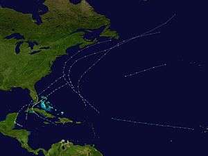
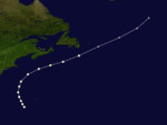
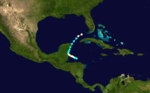
| Season summary map |
| First system formed |
July 30, 1870 |
| Last system dissipated |
November 3, 1870 |
| Strongest storm1 |
Four – 948 mbar (hPa) (27.99 inHg), 125 mph (205 km/h) |
| Total storms |
11 |
| Hurricanes |
10 |
| Major hurricanes (Cat. 3+) |
2 |
| Total fatalities |
Unknown |
| Total damage |
Unknown |
| 1Strongest storm is determined by lowest pressure |
Atlantic hurricane seasons
1868, 1869, 1870, 1871, 1872 |
The 1870 Atlantic hurricane season lasted from mid-summer to late-fall and comprised one tropical storm and ten hurricanes, two of which became major hurricanes, (Category 3+). However, in the absence of modern satellite and other remote-sensing technologies, only storms that affected populated land areas or encountered ships at sea were recorded, so the actual total could be higher. An undercount bias of zero to six tropical cyclones per year between 1851 and 1885 and zero to four per year between 1886 and 1910 has been estimated.[1]
Season summary
The Atlantic hurricane database (HURDAT) recognizes eleven tropical cyclones for the 1870 season. Ten storms attained hurricane status, with winds of 75 mph (119 km/h) or greater.Of the eleven Atlantic cyclones known for 1870 only three made landfall. Although Hurricane One caused damage in Alabama, the storm centre may not have crossed the coastline. Hurricane Nine made landfalls in both Cuba and Florida.Hurricane Two and Tropical Storm Three were both active in the first week of September but neither made landfall,although Hurricane Two did come close to the Newfoundland coastline.Later that month two more hurricanes were seen in the western Atlantic.Hurricane Four was an intense category three cyclone while Hurricane Five was a weaker category one storm.More notable was Hurricane Six.This hurricane, known as the Hurricane of San Marcos or the Straits of Florida Hurricane, caused massive flooding in Cuba and south Florida, resulting in 2,000 casualties [2] and at least $12million in damages.Hurricanes Seven and Eight were also active in the first half of October, both in the mid-Atlantic.Hurricane Nine made landfalls in both Cuba and Florida and was responsible for some 52 deaths.Hurricane Ten was sighted on October 23 near the Turks and Caicos Islands.The last cyclone of the year, Hurricane Eleven made landfall in Belize.
Timeline
Storms
Hurricane One
| Category 1 hurricane (SSHWS) |
|
|
| Duration |
July 30 – July 30 |
| Peak intensity |
80 mph (130 km/h) (1-min) 985 mbar (hPa) |
This storm is believed to have reached hurricane strength based upon damage reports from Mobile, Alabama.[3] No information on a track for the storm is available.[4]
Hurricane Two
| Category 2 hurricane (SSHWS) |
|
|
| Duration |
August 30 – September 4 |
| Peak intensity |
105 mph (165 km/h) (1-min) |
A tropical storm formed on August 30. The storm moved northwest towards the United States, before it peaked as a Category 2 hurricane. The storm then curved back to the northeast.It travelled parallel to the coast of Nova Scotia until it was last seen on September 4 near Newfoundland.[4]
Tropical Storm Three
| Tropical storm (SSHWS) |
|
|
| Duration |
September 1 – September 4 |
| Peak intensity |
70 mph (110 km/h) (1-min) 1004 mbar (hPa) |
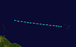
This storm was discovered near the Cape Verde islands on September 1. It headed to the west and approached hurricane strength. However, Tropical Storm Three was not upgraded to a hurricane and it would dissipate on September 4.[4]
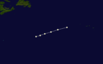
Hurricane Four
| Category 3 hurricane (SSHWS) |
|
|
| Duration |
September 9 – September 12 |
| Peak intensity |
125 mph (205 km/h) (1-min) 948 mbar (hPa) |
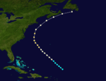
On September 9 a Category 2 hurricane was discovered a few hundred miles to the north of Puerto Rico.It later passed to the west of Bermuda as a Category 3 hurricane. It maintained Category 3 intensity until it was passing south of Newfoundland where it weakened to a Category 2 hurricane.It became extratropical on September 13.[4]
Hurricane Five
| Category 1 hurricane (SSHWS) |
|
|
| Duration |
September 17 – September 19 |
| Peak intensity |
90 mph (150 km/h) (1-min) 969 mbar (hPa) |
A hurricane was discovered to the southwest of Bermuda on September 17. It began to accelerate as it moved north but remained at sea during its entire duration and it became extratropical on September 20.[4]
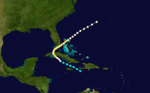
Hurricane Six
| Category 3 hurricane (SSHWS) |
|
|
| Duration |
October 5 – October 14 |
| Peak intensity |
115 mph (185 km/h) (1-min) 959 mbar (hPa) |
On October 5, a tropical storm developed south of Haiti. It moved west-northwest, becoming a hurricane south of Cuba on October 6. The hurricane rapidly strengthened to Category 3 with peak winds of 115 mph (185 km/h) prior to hitting Matanzas, Cuba on October 7.The combination of sustained high winds, intensive rainfall and two rivers, the San Juan and the Yumuri, bursting their banks destroyed the city and caused the loss of some 800 lives.[5] After crossing Cuba, the hurricane moved slowly northeastward through the Florida Straits generating Category 1 winds over the Florida Keys and causing an additional 1,200 deaths there.[2] It moved out to sea, last being seen on October 14.[4] Damage was estimated at over $12 million (USD).[5]
Hurricane Seven
| Category 1 hurricane (SSHWS) |
|
|
| Duration |
October 7 – October 7 |
| Peak intensity |
80 mph (130 km/h) (1-min) |
On October 7, a ship, the Horatio Harris, encountered a Category 1 hurricane several hundred miles west of the Cape Verde Islands. This appears to be the only known record of this storm.[3]
Hurricane Eight
| Category 1 hurricane (SSHWS) |
|
|
| Duration |
October 10 – October 11 |
| Peak intensity |
80 mph (130 km/h) (1-min) |
A Category 1 hurricane was discovered on October 10, more than 800 miles (1287 km) to the east of Bermuda.It headed east-northeast, toward the Azores. It dissipated before it was able to reach the islands.[4]
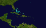
Hurricane Nine
| Category 2 hurricane (SSHWS) |
|
|
| Duration |
October 19 – October 22 |
| Peak intensity |
105 mph (165 km/h) (1-min) 970 mbar (hPa) |
On October 19 a hurricane was discovered in the Caribbean.The next day it made a landfall in western Cuba as a Category 2 hurricane, causing severe damage in Batabanó and Vuelta Abajo.[3]
Later on the 20th, it made landfall in Florida as a Category 1 hurricane.The centre of the hurricane passed over the Dry Tortugas, producing heavy rainfall.It later hit Chokoloskee, crossed the state, and moved out to sea.It eventually dissipated on October 22.[4] Hurricane Nine was responsible for 52 fatalities.[2]
Hurricane Ten
| Category 2 hurricane (SSHWS) |
|
|
| Duration |
October 23 – October 23 |
| Peak intensity |
105 mph (165 km/h) (1-min) |
A hurricane was discovered by two ships near the Turks and Caicos Islands on October 23.[3] It apparently dissipated shortly thereafter.[4]
Hurricane Eleven
| Category 1 hurricane (SSHWS) |
|
|
| Duration |
October 30 – November 3 |
| Peak intensity |
80 mph (130 km/h) (1-min) |
A tropical storm was first discovered on October 30 in the western Caribbean.It quickly strengthened into a hurricane before making landfall in Belize. After emerging into the Gulf of Mexico, the hurricane re-gained some strength but eventually dissipated on November 3.[4]
See also
References