1871 Atlantic hurricane season
| |
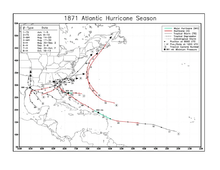
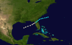
| Season summary map |
| First storm formed |
June 1, 1871 |
| Last storm dissipated |
October 13, 1871 |
| Strongest storm |
Three and Four – 105 knots (194 km/h; 121 mph) |
| Total storms |
8 |
| Major storms (Cat. 3+) |
2 |
| Total damage |
$5,000+ (1871 USD) |
| Total fatalities |
30+ |
Atlantic hurricane seasons
1869, 1870, 1871, 1872, 1873 |
The 1871 Atlantic hurricane season lasted from mid-summer to late-fall. Records show that 1871 featured two tropical storms, four hurricanes and two major hurricanes (Category 3+). However, in the absence of modern satellite and other remote-sensing technologies, only storms that affected populated land areas or encountered ships at sea were recorded, so the actual total could be higher. An undercount bias of zero to six tropical cyclones per year between 1851 and 1885 and zero to four per year between 1886 and 1910 has been estimated.[1] Of the known 1871 cyclones, both Hurricane Five and Hurricane Eight were first documented in 1995 by Jose Fernandez-Partagas and Henry Diaz, who also proposed large changes to the known tracks of Hurricane Three and of Hurricane Four.[2] Further analysis, in 2008, extended the duration of both Hurricane Three and Hurricane Seven, by one day each.[3]
Season summary
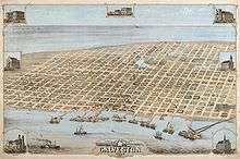
Galveston in 1871
The Atlantic hurricane database (HURDAT) recognizes eight tropical cyclones for the 1871 season. Two were tropical storms and six were hurricanes, with winds of 75 mph (119 km/h) or greater.Tropical Storm One traveled from south of Florida on June 1 to make landfall near Houston, Texas before dissipating further inland. The second tropical storm of the season also made landfall near Houston. Both storms caused considerable damage in Galveston and brought flooding to New Orleans. The third cyclone of the season, and the first hurricane, traveled west from the Bahamas to make landfall in central Florida.It passed through Florida, Georgia and South Carolina and out into the Atlantic.There it looped back and made landfall in Georgia as a tropical storm.Hurricane Four, the second hurricane of the season, started as a tropical storm west of Cape Verde.It crossed the Atlantic to make landfall, first in the Lesser Antilles,then in the Bahamas and then Florida before crossing the Florida peninsula into the Atlantic.Hurricane Five was a Category 2 hurricane,active between August 30 and September 2, that did not make landfall anywhere.Hurricane Six was a Category one hurricane that traveled from the Gulf of Mexico across Florida between September 5 and September 8.Hurricane Seven developed from a tropical storm, which was first seen in the Bay of Campeche on September 30.It strengthened to a Category 1 hurricane as it traveled off the Texas coast but weakened back to a tropical storm before crossing the Florida peninsula.This cyclone was responsible for numerous shipwrecks.Hurricane Eight, the last cyclone of the season was first seen as a Category 1 hurricane on
October 10, north-east of the British Virgin Islands.The hurricane traveled as far north as Nova Scotia before dissipating on October 13.
Timeline
Storms
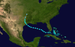
Tropical Storm One
| Tropical storm (SSHWS) |
|
|
| Duration |
June 1 – June 5 |
| Peak intensity |
60 mph (95 km/h) (1-min) 999 mbar (hPa) |
A strong, 50 mph (80 km/h) tropical storm was first observed south of Florida on June 1. The storm traversed through the Gulf of Mexico before making landfall near Houston, Texas as a tropical storm on June 4, where a minimum pressure of 999 mbar was measured. A station in Galveston, Texas recorded 3.95 inches (100 mm) of rain during a 14 minute time span on June 4.[4] Galveston was partially flooded with some railroads and buildings washed away.[2] One vessel, the steamship "Alabama" was thrown ashore at Galveston,while another,the "Virginia Dare" grounded on an offshore sandbar there.[5] Extremely heavy rains associated with this cyclone also caused flooding in New Orleans.[6] The New York Times,on June 6,reported that five hundred blocks of the city were submerged.[2] Eventually the storm dissipated in present-day Oklahoma.[7]
Tropical Storm Two
| Tropical storm (SSHWS) |
|
|
| Duration |
June 8 – June 10 |
| Peak intensity |
60 mph (95 km/h) (1-min) Unknown mbar (hPa) |
A tropical storm was first sighted north of the Yucatan Peninsula on June 8.The storm moved northwest and then north, eventually hitting Houston, Texas. The storm track was nearly identical to that of Tropical Storm One in terms of wind speed and point of landfall.[7] Many ships were wrecked and several houses and a church destroyed at Galveston.[5] Rain from this cyclone aggravated the flooding in New Orleans caused by Tropical Storm One a week earlier.[6]
Hurricane Three
| Category 3 hurricane (SSHWS) |
|
|
| Duration |
August 14 – August 23 |
| Peak intensity |
115 mph (185 km/h) (1-min) 952 mbar (hPa) |
A Category 1 hurricane was spotted northeast of The Bahamas on August 14. Hurricane Three continued on a westward track, eventually becoming a major hurricane east of the Abaco Islands. The hurricane maintained its intensity up until landfall in central east Florida on August 16 with winds of 120 mph (190 km/h). It passed over Ocala and moved west of Jacksonville.[3] After moving through Florida, Georgia, and South Carolina, the storm emerged in the Atlantic Ocean as a tropical storm . The storm then made a loop, making landfall in Georgia, as a tropical storm, early on August 23 before dissipating later the same day.[7]
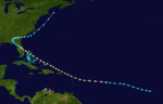
Hurricane Four
| Category 3 hurricane (SSHWS) |
|
|
| Duration |
August 17 – August 30 |
| Peak intensity |
115 mph (185 km/h) (1-min) 962 mbar (hPa) |
On August 17, a tropical storm developed west of Cape Verde. The system progressed on a west-northwest track and steadily intensified, becoming a major hurricane east of the Lesser Antilles. On August 21, at peak intensity with winds of up to 120 mph (190 km/h), the hurricane passed over Antigua, St. Eustatius, Saint Kitts and St.Thomas. Continuing to track to the northeast it passed 30 miles northeast of Fajardo.[8] The hurricane then weakened to a Category 2 hurricane, maintaining this strength while making further landfalls in The Bahamas and Florida, respectively. The storm weakened over Florida before entering the Gulf of Mexico and making a final landfall on the Florida Panhandle as a tropical storm. The storm then moved north and east over land, weakening into a tropical depression before strengthening back into a tropical storm after re-emerging off South Carolina into the Atlantic. The storm was last sighted east of Cape Cod.[7] The hurricane caused numerous shipwrecks,[2] including three ships lost at Puerto Rico,[8] and left 27 people dead at St.Thomas.[9]
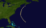
Hurricane Five
| Category 2 hurricane (SSHWS) |
|
|
| Duration |
August 30 – September 2 |
| Peak intensity |
105 mph (165 km/h) (1-min) Unknown mbar (hPa) |
The only storm of the year not to make landfall, Hurricane Five was first observed as a Category 2 hurricane with winds of 100 mph (160 km/h) north of Puerto Rico on August 30. Hurricane Five maintained this intensity until it was last observed south of Nova Scotia. It is possible that the storm made landfall on Nova Scotia and it is also possible that the storm formed before August 30.[7]
Hurricane Six
| Category 1 hurricane (SSHWS) |
|
|
| Duration |
September 5 – September 8 |
| Peak intensity |
80 mph (130 km/h) (1-min) 985 mbar (hPa) |
A hurricane formed near the geographic center of the Gulf of Mexico on September 5. The next day, it made landfall in Florida as a Category 1 hurricane. It brought heavy rainfall to Florida and Georgia before entering tha Atlantic off the east coast of Georgia.[10] Still continuing to the northeast, it was last sighted south of Cape Hatteras.[7]
Hurricane Seven
| Category 1 hurricane (SSHWS) |
|
|
| Duration |
September 30 – October 7 |
| Peak intensity |
80 mph (130 km/h) (1-min) Unknown mbar (hPa) |
A tropical storm was first sighted in the Bay of Campeche on September 30. It continued moving in a northeast direction, paralleling the Texas coast and strengthening to a Category 1 hurricane while doing so. The hurricane then nearly made landfall on the Mississippi Delta. It finally made landfall on the Florida Panhandle as a strong tropical storm with winds of 70 mph (113 km/h). After re-entering the Atlantic Ocean, the storm was last sighted east of Cape Hatteras.[7] At least three people were killed at Galveston and several ships were wrecked or foundered, some with the loss of all hands.[5]
Hurricane Eight
| Category 1 hurricane (SSHWS) |
|
|
| Duration |
October 10 – October 13 |
| Peak intensity |
80 mph (130 km/h) (1-min) Unknown mbar (hPa) |
A hurricane was first observed northeast of the British Virgin Islands on the morning of October 10. At this point it was already a Category 1 hurricane with winds of 80 mph (129 km/h). Its intensity remained steady at that level as it traveled first west, then veered north before travelling parallel to the US coast. The hurricane dissipated shortly after making landfall at Nova Scotia on October 13.[7]
See also
References
- ↑ Landsea, C. W. (2004). "The Atlantic hurricane database re-analysis project: Documentation for the 1851–1910 alterations and additions to the HURDAT database". In Murname, R. J.; Liu, K.-B. Hurricanes and Typhoons: Past, Present and Future. New York: Columbia University Press. pp. 177–221. ISBN 0-231-12388-4.
- 1 2 3 4 Partagas, J.F. and H.F. Diaz, 1995b "A Reconstruction of Historical Tropical Cyclone Frequency in the Atlantic from Documentary and other Historical Sources : 1851-1880 Part II: 1871-1880" Climate Diagnostics Center, NOAA, Boulder, CO
- 1 2 Hurricane Research Division (2008). "Documentation of Atlantic Tropical Cyclones Changes in HURDAT". National Oceanic and Atmospheric Administration. Retrieved 2011-03-14.
- ↑ J. L. H. Paulhaus (1973). World Meteorological Organization Operational Hydrology Report No. 1: Manual For Estimation of Probable Maximum Precipitation. World Meteorological Organization. p. 178.
- 1 2 3 David Roth (2010-02-04). "Texas Hurricane History" (PDF). National Weather Service. Retrieved 2011-06-22.
- 1 2 David M. Roth (2010-01-13). Louisiana Hurricane History (PDF). National Weather Service Southern Region Headquarters. Retrieved 2011-01-25.
- 1 2 3 4 5 6 7 8 Hurricane Research Division (2008). "Easy to Read HURDAT". National Oceanic and Atmospheric Administration. Retrieved January 23, 2010.
- 1 2 José Colón (1970). Pérez, Orlando, ed. "Notes on the Tropical Cyclones of Puerto Rico, 1508–1970" (Pre-printed). National Weather Service: 26. Retrieved September 27, 2012.
- ↑ Edward N. Rappaport & Jose Fernandez-Partagas (1996). "The Deadliest Atlantic Tropical Cyclones, 1492–1996: Cyclones with 25+ deaths". National Hurricane Center. Retrieved 2011-03-14.
- ↑ Al Sandrik & Chris Landsea (2003). "Chronological Listing of Tropical Cyclones affecting North Florida and Coastal Georgia 1565-1899". Hurricane Research Division. Archived from the original on 6 December 2006. Retrieved 2007-01-02.