2006 Mozambique earthquake
 Espungabera Chimoio Beira Maputo | |
| Date | February 22, 2006 |
|---|---|
| Origin time | 22:19:7.8 |
| Magnitude | 7.0Mw[1] |
| Depth | 11 kilometres (7 mi) |
| Epicenter | 21°19′26″S 33°34′59″E / 21.324°S 33.583°ECoordinates: 21°19′26″S 33°34′59″E / 21.324°S 33.583°E |
| Type | Dip-slip[2] |
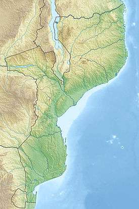
| Areas affected | Southern Mozambique |
| Max. intensity | VIII (Severe) |
| Aftershocks | 5.7 Mw Feb 23 at 01:23[2] |
| Casualties | 4 dead, 36 injured[2] |
The 2006 Mozambique earthquake occurred at 22:19 UTC on 22 February. It had a magnitude of 7.0 on the moment magnitude scale and caused 4 deaths and 36 injuries. The epicenter was near Machaze in Manica Province of southern Mozambique, just north of the Save River. It was the largest historical earthquake in Mozambique and the first earthquake in southern Africa to have an identified surface rupture.[3]
Tectonic setting
Southern Mozambique is at the southern end of the East Africa Rift system, where the African Plate appears to be breaking into several smaller plates.[4] The Somali Plate is moving westward relative to the Nubian Plate at a rate of several millimetres a year at the latitude of this earthquake. Most earthquakes in this zone are a result of either normal or strike-slip faulting.
Earthquake

The earthquake was felt throughout Mozambique and over a wide area of eastern southern Africa, including South Africa, Swaziland, Zambia, Zimbabwe and Botswana.[4] Close to the epicentre the shaking reached VIII in intensity on the Mercalli intensity scale.[5] In the cities of Beira, Inhambane and Maputo the intensity reached V.
The focal mechanism of the earthquake is consistent with normal faulting on a westerly dipping fault plane. Field investigations identified 15 km of surface rupture in the form of a west-facing scarp, with up to 2.05 m of vertical displacement, although it was not possible to prove the full extent of surface faulting due to lack of time and the presence of minefields.[3] Investigations using Interferometric synthetic aperture radar (InSAR), combined with field and seismological observations, have identified two fault segments with slightly differing strikes, with the hypocenter and most of the displacement being on the more southerly of the segments.[6]
Damage
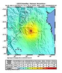
Little damage was recorded, with only 294 buildings reported as damaged in the area between Espungabera, Beira and Chimoio.[5] A total of four deaths were recorded, one in Espungabera, one in Machaze and two in Beira, with a further thirty-six injured.
References
- ↑ "Comments for the Significant Earthquake". National Geophysical Data Center. Retrieved 6 December 2014.
- 1 2 3 USGS (September 4, 2009), PAGER-CAT Earthquake Catalog, Version 2008_06.1, United States Geological Survey
- 1 2 Fenton C.H. "The first recorded surface rupture in southern Africa: the 22 February 2006 M 7.0 Machaze, Mozambique, earthquake". Retrieved 8 December 2014.
- 1 2 "M7.0 Mozambique Earthquake of 22 February 2006" (PDF). USGS. Retrieved 8 December 2014.
- 1 2 "M7.0 - Mozambique". USGS. Retrieved 29 March 2015.
- ↑ Copley A., Hollongsworth J. & Bergman E. (2012). "Constraints on fault and lithosphere rheology from the coseismic slip and postseismic afterslip of the 2006 M w 7.0 Mozambique earthquake" (PDF). Journal of Geophysical Research. 117 (B03404). doi:10.1029/2011JB008580.