2006 Yogyakarta earthquake
 Jakarta Pangandaran Yogyakarta | |
| Date | 27 May 2006 |
|---|---|
| Origin time | 05:54 local time [1] |
| Magnitude | 6.4 Mw [1] |
| Depth | 15 km (9 mi) [1] |
| Epicenter | 8°04′S 110°21′E / 8.07°S 110.35°ECoordinates: 8°04′S 110°21′E / 8.07°S 110.35°E [1] |
| Type | Strike-slip |
| Areas affected |
|
| Total damage | Extreme [2] |
| Max. intensity | IX (Destructive) [3] |
| Peak acceleration | .336g [4] |
| Casualties |
5,749–5,778 dead [5] 38,568–137,883 injured [5] 600,000–699,295 displaced [5] |
The 2006 Yogyakarta earthquake (also known as the Bantul earthquake) occurred at 05:54 local time on 27 May with a moment magnitude of 6.4 and a maximum intensity of IX (Destructive) on the Medvedev–Sponheuer–Karnik scale. The shock occurred on the southern coast of Java near the Indonesian city of Yogyakarta, and caused a disproportionate number of casualties, with more than 5,700 deaths, tens of thousands injured, and financial losses of Rp 29.1 Trillion ($3.1B). The United States' National Geophysical Data Center lists the total damage from the event as extreme.
Previous volcanic deposits and lahars that flowed off Mount Merapi were found to have amplified the intensity of the shaking and created the conditions for soil liquefaction to occur, but the concurrent activity on the stratovolcano was not directly connected with the earthquake. With a lack of instruments in the area, the shock was initially attributed with the Opak Fault that lies to the east of the affected areas, but later InSAR analysis revealed that another previously unknown fracture was responsible for the sequence of shocks.
Tectonic setting
The islands of Indonesia constitute an island arc that is one of the world's most seismically active regions, with high velocity (up to 60 mm (2.4 in) per year) plate movement at the Sunda Trench, and considerable volcanic activity throughout. The south central portion of the island of Java (one of the five largest in the Indonesian archipelago) had been affected by an eruption of Mount Merapi that began prior to the May 27 earthquake, but the Special Region of Yogyakarta has experienced numerous other eruptions, earthquakes, and tsunamis, including the Pangandaran earthquake and tsunami that occurred just two months later. Java lies on the Sunda Shelf (and the Sunda microplate) to the north of the Sunda Trench, which is a convergent plate boundary where the Indo-Australian Plate is being subducted under the Eurasian Plate. The subduction zone is characterized by frequent earthquakes and a large number of active volcanoes that influence the regional geography, and due to direct or indirect stress transfer, the offshore plate movement has affected the various onshore faults that are closer to the Special Region of Yogyakarta.[6]
Earthquake
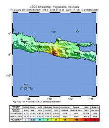
According to the United States Geological Survey (USGS), the shock occurred 20 km (12 mi) south-southeast of Yogyakarta at a depth of 10 km (6.2 mi), but other institutions provided source parameters (location and depth) that were not in agreement. No information was present on the extent of the faulting or the direction of propagation, but the shock was unlikely to be related to the eruption of Mount Merapi. The USGS suggested that the focal mechanism was most likely associated with left-lateral slip on a NE–SW trending strike-slip fault, as that is the orientation of the Opak Fault, but this has not been validated. No surface breaks were documented, but the location of the greatest damage that was caused does align with the Opak Fault as a possible source.[7]
A group of Japanese and Indonesian scientists visited the area in March 2007 and confirmed the lack of surface ruptures, and pointed out that any visible expression of the fault would likely have been rapidly destroyed due to the tropical climate, and have acknowledged the widely varying locations (and the preference for the Opak Fault) that were reported by the various seismological institutions. Their investigation resulted in a different scenario, with an unknown or newly formed NE–SW trending fault as the origin of the shock. Evidence for one of the proposed faults was found in the form of alignment of portions of the Oyo River near the USGS' epicenter, which is parallel (N°65E) to the Nglipar fault in the southern mountains region. If the shock occurred in this area it could indicate the reactivation of a major fault system. The second proposed fault further to the east is nearly parallel to the Nfalang and Kembang faults that lie to the north of the Oyo River.[8]
InSAR analysis
While the densely populated area that saw significant destruction is adjacent to the Opak River Fault, both the USGS and Harvard University placed the epicenter to the east of that fault. Few seismometers were operating in the region, but a group of temporary units that were set up following the mainshock recorded a number of aftershocks that were east of the Opak River Fault and were aligned along a 20 km (12 mi) zone striking N°50E. Due to the ambiguous nature of the available information on the source of the Yogyakarta earthquake, a separate group of Japanese and Indonesian scientists applied one of the first uses of Interferometric synthetic aperture radar (InSAR) to determine the source fault. Several data sets (one captured in April 2006 and another post-earthquake batch from June) were collected from an instrument on board the Advanced Land Observation Satellite and were compared to each other to show potential ground deformation patterns.[9]

A lack of any dislocation found on the images along the Opak River fault made evident the lack of movement along that fault, and though the aftershocks were occurring at a depth of 8–15 km (5.0–9.3 mi), the deformation was distinct at the surface. The observed ground deformation that was detailed by the differential satellite images and Global Positioning System measurements was roughly 10 km (6.2 mi) east of (and parallel to) the Opak River Fault, along a zone that passed through the USGS' epicenter, and delineated a fault with a strike of N48°E and a dip of 89°. The displacements were not more than 10 cm (3.9 in) and indicated left-lateral strike-slip motion as well as a component of reverse slip, and to the west of the Opak River Fault (and closer to the areas of damage) strong ground motion triggered subsidence of volcanic deposits from Mount Merapi.[9]
Strong motion
In 2006, Mount Merapi had not been active for more than four years, but on May 11 a pyroclastic flow triggered the evacuation of more than 20,000 people from the northern sector of Yogyakarta. While authorities expected a larger eruption to follow, the earthquake occurred instead. The volcano's previous eruptions deposited loosely bound sedimentary material in the valley during lahar flows. Following the mainshock, German and Indonesian scientists set up instruments at several locations situated on different soil types to measure aftershocks. Of nine events that were analyzed, it was found that the station at Imogiri (a heavily affected village that was built on 150–200 meters (490–660 ft) of sediment) showed signs of local amplification when compared to a location that was built on bedrock, and that the deposits amplified the impact of the earthquake.[10]
Liquefaction
A separate post-event study looked at the relationship with the layer of sediment and the occurrence of soil liquefaction during earthquakes near Bantul. Researchers stated that the Yogyakarta region is seismically active, with four known events in the 19th century and three in the 20th century, with peak ground acceleration values of 0.038–0.531g. The type and properties of sediment control the occurrence and distribution of liquefaction, and other environmental conditions (like the water table) also play a part, as well as the peak ground acceleration of the earthquake. The Bantul-Klaten plain consists of alluvium (sand, silt, clay, and gravel) and volcanic deposits from Merapi (sand, agglomerates, tuff, and ash), as well as limestone and sandstone. Borehole and magnetic data surveys show that the alluvium and lahar deposits at the Bantul graben are 20–200 meters (66–656 ft) thick and at places over 200 meters, and the water table is .6–5 meters (2 ft 0 in–16 ft 5 in) below ground level. Most liquefaction events took place near the 2.5 km (1.6 mi) wide Opak Fault zone. Sand boils, lateral spreading, settling, and slides led to some tilting and collapse of buildings.[11]
Damage
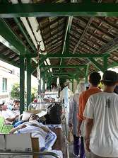
Altogether, eleven densely populated districts comprising 8.3 million people were affected, but the regencies of Bantul, Sleman, Gunung Kidul, Kulon Progo, Klaten, and the city of Yogyakarta were especially hard hit. More than 5,700 people were killed in the early morning shock, with tens of thousands injured, and several hundred thousand made homeless. Total financial losses from the event are estimated to be Rp 29.1 Trillion ($3.1B), with 90% of the damage affecting the private sector (homes and private businesses) and only 10% affecting the public sector. The damage to housing accounted for about half of the total losses and a comparison was made to the damage in Aceh following the 2004 Indian Ocean earthquake and tsunami. Damage in central Java was worse because of the substandard construction practices and the high population density. On the other end of the scale, damage to infrastructure was very limited.[12]
Response
Although Tsunami warnings were issued in the early aftermath of the earthquake, the earthquake did not cause any tsunami activity.
Political
President Susilo Bambang Yudhoyono moved the army to the central Java province to aid rescue efforts and the evacuation of victims. A team of Cabinet Ministers was also sent to oversee the operations.
International aid
Many countries and organizations offered foreign aid to the devastated region, but the actual amounts delivered/received often varied from these figures, as in the case of other disasters.
- Japan promised US$10 million, sent two medical teams and also announced that it will send troops to help out[13]
- The United Kingdom offered four million pounds (US$7,436,800)[13]
- Saudi Arabia promised US$5 million, plus food, medical equipment and tents, while the United Arab Emirates and Kuwait each pledged US$4 million[13]
- The European Union offered three million euros (US$3,800,000)[14]
- The United States offered $5 million; US military joins relief effort[15]
- Australia offered 7.5 million Australian dollars (US$5,675,000) in aid relief, including 27 member medical team among over 80 personnel[16]
- China offered $2 million U.S dollars[17]
- Canada offered two million Canadian dollars (US$1.8 million)[18]
- India put forward an aid package worth $2 million.[19]
- The Church of Jesus Christ of Latter-day Saints (Mormons) donated US$1.6 million worth of emergency supplies to devastated areas, teaming up with Islamic Relief Worldwide who provided the transportation. In addition, local Indonesian LDS members prepared thousands of meals, hygiene kits, cots, mattresses, and blankets for those requiring medical attention.[20]
- The Netherlands promised 1 million euros in May plus an extra 10 million euros one month later, Belgium has pledged $832,000, while Norway, France and Italy have offered either medical teams or relief supplies[13]
- The Red Cross, Red Crescent, OXFAM, Plan International, Jesuit Refugee Service alongside other NGOs and UN agencies, including WFP and UNICEF, provided plastic sheeting, tools and building materials, and cash assistance to the victims.[14] Japan and Malaysia are to send medical teams to the affected region[21]
- Singapore offered humanitarian relief assistance in the form of a 35-member Armed Forces Medical Team, a 43-member Civil Defense Force Disaster Assistance and Rescue Team, as well as US$50,000 worth of emergency supplies[22]
- The United Nations World Health Organization sent medicines and communications equipment, enough emergency health kits to last 50,000 people three months, and surgical kits for as many as 600 operations[23]
- Vietnam offered 1,000 tons of rice to Indonesia.[24]
- The Isle of Man offered £30,000 (US$56,291) to Indonesia[25]
- King Abdullah II of Jordan ordered to dispatch a plane laden with humanitarian relief to alleviate the suffering of Indonesian earthquake victims that hit Java. The aid included blankets, medicines and other medical equipment.[26]
- MERCY Malaysia[27] sent 6 Missions to Yogya the first being sent on the 28th of May 2006. Datuk Dr. Jemilah Mahmood, President of MERCY Malaysia (Mission Leader) and Saiful Nazri, Programme Officer from MERCY Aceh Office went there on the first mission travelling by a special United Nations Humanitarian Air Services (UNHAS) flight from Banda Aceh along with other international organisations based in Aceh and two (2) tonnes of medical supplies contributed by the international agencies from Aceh. The first team had secured ground logistics for the subsequent teams coming in from Kuala Lumpur.
Media
Most international wire services had already had reporters or 'stringers' in the area due to the Mount Merapi eruption to the north of Yogyakarta.
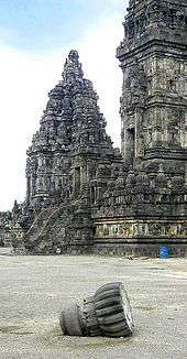
Yogyakarta for many is associated with Borobudur and Prambanan, even though both locations are some distance away from the town. As a result, news stories tend to emphasize the condition of those places. Borobudur suffered no damage whereas Prambanan, which is much closer to the epicentre, has according to reports,[28] suffered significant damage.
The reporting of the immensity of the problems that were evolving following the earthquake also competed with the crisis in East Timor (Timor Leste) in the media of some countries like Australia and New Zealand.
Reconstruction
The earthquake's shallow depth was a major factor, but the scale of the damage was made worse by failure to meet safe building standards and employ basic earthquake-resistant construction methods, according to FuturArc.[29] Most homes in the area were built with low-quality materials without structural frames and reinforcing pillars. Many deaths and injuries occurred when buildings and walls collapsed.
The government was slow to implement assistance in reconstructing private houses, leading many homeowners to repair or rebuild their homes either by themselves or with community help. Reconstruction in some areas was aided by relief agencies, like the Red Cross Red Crescent.
Villagers rebuilt their homes with extremely limited resources, using simple affordable materials. They turned to traditional materials, such as bamboo, because of the damage inflicted by collapsing brick walls.
See also
-
 Indonesia portal
 - Bantul
- List of earthquakes in 2006
- List of earthquakes in Indonesia
- Sidoarjo mud flow
References
- 1 2 3 4 ISC (2015), ISC-GEM Global Instrumental Earthquake Catalogue (1900–2009), Version 2.0, International Seismological Centre
- ↑ National Geophysical Data Center / World Data Service (NGDC/WDS), Significant Earthquake Database, National Geophysical Data Center, NOAA, doi:10.7289/V5TD9V7K
- ↑ Murakami, H.; Pramitasari, D.; Ohno, R. (2008), Human casualty and damage distribution in relation to seismic intensity in the 2006 Central Java earthquake in Indonesia (PDF)
- ↑ Elnashai et al. 2006, p. 18
- 1 2 3 USGS (September 4, 2009), PAGER-CAT Earthquake Catalog, Version 2008_06.1, United States Geological Survey
- ↑ Marso, J.; Anderson, R.; Frost, E. (2008), "A short note on the tectonic setting and regional geology of the area affected by the May 27, 2006, Yogyakarta earthquake and its usefulness in assessing seismic hazard", The Yogyakarta earthquake of May 27, 2006, Star Publishing Company, Inc., pp. 1.1–1.3, ISBN 978-0-89863-304-7
- ↑ Elnashai et al. 2006, pp. 9, 15
- ↑ Setijadji, L. D.; Barianto, D. H.; Watanabe, K.; Fukuoka, K.; Ehara, S.; Rahardjo, W.; Sudarno, I.; Shimoyama, S.; Susilo, S.; Itaya, T. (2008), "Searching for the active fault of the Yogyakarta earthquake of 2006 using data integration on aftershocks, cenozoic geo-history, and tectonic geomorphology", The Yogyakarta earthquake of May 27, 2006, Star Publishing Company, Inc., pp. 4.1–4.4, 4.17, 4.18, ISBN 978-0-89863-304-7
- 1 2 Tsuji, T.; Yamamoto, K.; Matsuoka, T.; Yamada, Y.; Onishi, K.; Bahar, A.; Meilano, I.; Abidin, H. Z. (2009), "Earthquake fault of the 26 May Yogyakarta earthquake observed by SAR interferometry" (PDF), Earth, Planets and Space, Terra Scientific Publishing Company, 61: e29–e32
- ↑ Walter, T. R.; Wang, R.; Luehr, B.-G.; Wassermann, J.; Behr, Y.; Parolai, S.; Anggraini, A.; Günther, E.; Sobiesiak, M.; Grosser, H.; Wetzel, H.-U.; Milkereit, C.; Sri Brotopuspito, P. J. K.; Harjadi, P.; Zschau, J. (2008), "The 26 May 2006 magnitude 6.4 Yogyakarta earthquake south of Mt. Merapi volcano: Did lahar deposits amplify ground shaking and thus lead to the disaster?", Geochemistry, Geophysics, Geosystems, Wiley, 9 (5): 2, 5, 6, doi:10.1029/2007GC001810
- ↑ Sarah, D.; Soebowo, E. (2013), "Liquefaction Due to the 2006 Yogyakarta Earthquake: Field Occurrence and Geotechnical Analysis", Procedia Earth and Planetary Sciences, International Symposium on Earth Science and Technology, CINEST 2012, Elsevier, 6: 383–388, doi:10.1016/j.proeps.2013.01.050
- ↑ CGI 2006, pp. 3, 7, 12, 13, 15
- 1 2 3 4 "Aid pledges for Java victims rise". BBC News. 2006-05-29. Retrieved 2006-05-29.
- 1 2 "Aid offers pour in for Java quake". BBC News. 2006-05-28. Retrieved 2006-05-28.
- ↑ "U.S. Military Joins Indonesia Quake Relief". CBS News. 2006-05-31. Archived from the original on June 14, 2006. Retrieved 2006-05-31.
- ↑ "Australia send 80 skilled personnel to Yogyakarta". Antara. 2006-05-31. Retrieved 2006-05-31.
- ↑ "China to offer 2 mln dollars aid to quake-hit Indonesia". People's Daily Online. 2006-05-28. Retrieved 2006-05-28.
- ↑ "Ottawa pledges $2M to Indonesia quake victims; no Canadians reported affected". Maclean's. 2006-05-27. Archived from the original on June 14, 2006. Retrieved 2006-05-28.
- ↑ "India steps up aid to Indonesia". The Hindu. 2006-05-29. Retrieved 2006-05-30.
- ↑ "Mormons Donate for Indonesia Earthquake Relief". The Church of Jesus Christ of Latter-day Saints Newsroom. 2006-05-31. Retrieved 2006-05-31.
- ↑ "All our students in Yogyakarta safe". The Star, Malaysia. 2006-05-28. Retrieved 2006-05-28.
- ↑ "Singapore's aid teams arrive in quake-hit Java". Channel NewsAsia. 2006-05-28. Retrieved 2006-05-28.
- ↑ "UN health agency rushes aid to quake-struck parts of Indonesia". UN News Centre. 2006-05-29. Retrieved 2006-05-30.
- ↑ "Vietnam sends rice aid to Java quake victims". VietNamNet Bridge. 2006-05-31. Archived from the original on 2006-06-13. Retrieved 2006-05-31.
- ↑ "Island aid for Indonesia". Manx Radio. 2006-05-31. Archived from the original on May 6, 2006. Retrieved 2006-06-01.
- ↑ "King orders dispatch of aid to Indonesian Earthquake Victims". Petra News Agency (Jordan). 2006-05-31. Archived from the original on June 14, 2006. Retrieved 2006-06-01.
- ↑ http://www.mercy.org.my/read.php?id=24
- ↑ Sebastien Berger (2006-05-30). "An ancient wonder reduced to rubble". The Sydney Morning Herald. Retrieved 2006-05-30.
- ↑ http://www.futurarc.com/this_edition/discussion_lesson_learned.cfm
Sources
- CGI (2006), Preliminary Damage and Loss Assessment – Yogyakarta and Central Java Natural Disaster (PDF), The 15th Meeting of The Consultative Group on Indonesia, Jakarta, June 14, 2006
- EERI (2006), The Mw 6.3 Java, Indonesia, Earthquake of May 27, 2006 (PDF), EERI Special Earthquake Report, Earthquake Engineering Research Institute
- Elnashai, A. S.; Jig Kim, S.; Jin Yun, G.; Sidarta, D. (2006), The Yogyakarta Earthquake of May 27, 2006 (PDF), MAE Center Report No. 07-02, Mid-America Earthquake Center, Newmark Civil Engineering Lab, University of Illinois at Urbana–Champaign
- Karnawati, D.; Pramumijoyo, S.; Hussein, S.; Anderson, R.; Ratdomopurbo, A. (2007), Geological Influence on the Site Response of Bantul Earthquake at Yogyakarta Special Province, Indonesia, American Geophysical Union, Spring Meeting 2007, abstract #S31C-02
- Murakami, H.; Pramitasari, D.; Ohno, R. (2008), Human casualty and damage distribution in relation to seismic intensity in the 2006 Central Java earthquake in Indonesia (PDF), The 14th World Conference on Earthquake Engineering, October 12–17, 2008, Beijing, China
External links
| Wikinews has related news: Earthquake kills thousands in Indonesia |
- M6.3 - Java, Indonesia – United States Geological Survey
- Indonesia earthquake – CNN Special Report
- An ancient wonder reduced to rubble – The Sydney Morning Herald
- UN health agency rushes aid to quake-struck parts of Indonesia – United Nations