2009 Tonga undersea volcanic eruption
Coordinates: 20°34′S 175°23′W / 20.57°S 175.38°W
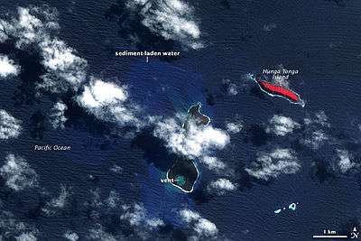
The 2009 Tonga undersea volcanic eruption began on March 16, 2009,[1] near the island of Hunga Tonga, approximately 11 kilometres (6.8 mi) from the Tongan capital of Tongatapu.[2] The volcano is in a highly active volcanic region that represents a portion of the Pacific Ring of Fire. It is estimated that there are up to 36 undersea volcanoes clustered together in the area.[3]
Eruption history
The initial March 16–17 eruption sent ash and smoke up to 20 kilometres (12 mi) into the atmosphere and an initial inspection reported that the volcano has breached the ocean surface.[4][5] Authorities suggested at that time that the eruption did not yet pose any threat to the capital's population, and an inspection team was sent out to evaluate the volcano.[6][7]
Between March 18–20, a number of Surtseyan eruptions sent ash plumes as high as 4 kilometres (2.5 mi) to 5.2 kilometres (3.2 mi) into the atmosphere, with prevailing winds pushing the ash cloud about 480 kilometres (300 mi) east-northeast of the eruption site and widespread and significant haze reported at Vavaʻu 255 kilometres (158 mi) away.[8] Steam plumes on March 20 were measured at 1.8 kilometres (1.1 mi) above sea level.[8] But on March 21, an eruption sent steam and ash just 0.8 kilometres (0.50 mi) into the sky.[8] On March 21, Tonga's chief geologist Kelepi Mafi reported lava and ash from two vents, one on the uninhabited island Hunga Haʻapai and another about 100 m (330 ft) offshore, had filled the gap between the two vents, creating new land surface that measured hundreds of square metres.[9][10] The eruption devastated Hunga Haʻapai, covering it in black ash and stripping it of vegetation and fauna.[10]
Disruptions
Two Air New Zealand airline flights into Tonga were delayed due to safety concerns caused by the volcanic ash, but flight schedules returned to normal shortly thereafter.[11]
Tongan officials also expressed concern that the eruption could significantly harm the country's fishing industry.[12]
2009 Tonga earthquake
Four days after the start of the eruption a strong earthquake measuring 7.6 on the Richter scale also struck the region. Ken Hudnut, a geophysicist for the United States Geological Survey, stated that "The association with the volcanic activity seems to be an interesting added dimension to this. It's not clear at this point that there is a direct association, but it seems suggestive at this point.".[2] Keleti Mafi, the Tongan government's chief seismologist, also suggested that the earthquake was likely to have a direct impact on the volcanic eruption, stating that the "strength of the earthquake could crack the volcano's (undersea) vent and allow more magma to be ejected".[4]
References
- ↑ The date the eruption began was initially uncertain. According to the Smithsonian Institution's Global Volcanism program, "Observers flying near the area of Hunga Tonga-Hunga Ha'apai (about 62 km NNW of Nuku'alofa, the capital of Tonga) on 16 or 17 March reported seeing an eruption." See: SI/USGS Weekly Volcanic Activity Report. 11 March-17 March 2009. The report cites Keizo Gates' Web log, dated March 16, 2009, which contains photos allegedly taken from civilian aircraft late on the afternoon of March 16. See: Gates, Keizo. "New Tonga Eruption" Kzo.net. March 16, 2009. The Smithsonian subsequently confirmed that the eruption began on March 16. See: SI/USGS Weekly Volcanic Activity Report. 18 March-24 March 2009.
- 1 2 "Major quake strikes off Tonga". CNN. 2008-03-19. Archived from the original on 22 March 2009. Retrieved 2009-03-19.
- ↑ "Undersea Volcano Erupts Off Tonga Coast". Fox News. 2009-03-18. Archived from the original on 2009-08-16. Retrieved 2009-03-20.
- 1 2 "Strong quake near Tonga prompts tsunami warning". Yahoo News. 2009-03-20. Archived from the original on March 23, 2009. Retrieved 2009-03-21.
- ↑ Barrowclough, Anne (2009-03-20). "Underwater volcano sends huge columns of ash into Pacific sky". London: The Times. Retrieved 2009-03-20.
- ↑ "Tongan inspection team heads to undersea volcano". Yahoo News. 2009-03-19. Archived from the original on March 22, 2009. Retrieved 2009-03-20.
- ↑ "Tongan Inspectors Head to Undersea Volcano." Associatededed Press. March 19, 2009.
- 1 2 3 SI/USGS Weekly Volcanic Activity Report. 18 March-24 March 2009.
- ↑ Percival, Jenny. "Underwater Volcano Creates New Island Off Tonga." The Guardian. 21 March 2009.
- 1 2 "'No Living Thing Left' As Tonga Volcano Erupts." Agence France Presse. March 20, 2009.
- ↑ "Night Flights Postponed As Volcanic Activity Continues." Matangi Tonga. March 23, 2009; "Flights Back to Normal But Tongan Volcanoes Still Erupting." Radio New Zealand International. March 24, 2009.
- ↑ "Tonga Examines Volcano's Fishing Impact." Radio Australia News. March 23, 2009.
External links
- Footage of the eruption, BBC website
- "The Big Picture - Undersea eruptions near Tonga". The Boston Globe. 19 March 2009. Archived from the original on 22 March 2009. Retrieved 22 March 2009.