2011 Cordova, Alabama tornado
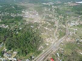 Aerial view of the damage path through Cordova from the west (looking east). | |
| Type | Tornado |
|---|---|
| Formed | April 27, 2011, 3:40 p.m. CDT (UTC−05:00) |
| Dissipated | April 27, 2011, 5:56 p.m. CDT (UTC−05:00) |
| Max rating1 | EF4 tornado |
| Highest winds |
|
| Casualties | 13 fatalities, 54 injuries |
|
1Most severe tornado damage; see Fujita scale Part of the 2011 Super Outbreak | |
On April 27, 2011, a very long-tracked EF4 tornado touched down in Pickens County, northeast of Pickensville, killing 13 people and injured 54 others along its 116-mile (187 km) path.
Meteorological synopsis
The environmental conditions leading up to the April 2011 Super Outbreak were among the "most conducive to violent tornadoes ever documented".[1] On April 25, a vigorous upper-level shortwave trough that moved into the Southern Plains states.[2] Ample instability, low-level moisture, and wind shear fueled a significant tornado outbreak from Texas to Tennessee; at least 64 tornadoes touched down on this day.[1] An area of low pressure consolidated over Texas on April 26 and traveled east while the aforementioned shortwave trough traversed the Mississippi River and Ohio River valleys.[3] Another 50 tornadoes touched down on this day.[1] The multi-day outbreak culminated on April 27 with the most violent day of tornadic activity since the 1974 Super Outbreak. Multiple episodes of tornadic activity ensued with two waves of mesoscale convective systems in the morning hours followed by a widespread outbreak of supercells from Mississippi to North Carolina during the afternoon into the evening.[1]
Activity on April 27 was precipitated by a 995 mbar (hPa; 29.39 inHg) surface low situated over Kentucky and a deep, negatively tilted (aligned northwest to southeast) trough over Arkansas and Louisiana. A strong southwesterly surface jet intersected these systems at a 60° angle, an ageostrophic flow that led to storm-relative helicity values in excess of 500 m2s−2—indicative of extreme wind shear and a very high potential for rotating updrafts within supercells. Ample moisture from the Gulf of Mexico was brought north across the Deep South, leading to daytime high temperatures of 77 to 81 °F (25 to 27 °C) and dewpoints of 66 to 72 °F (19 to 22 °C). Furthermore, convective available potential energy (CAPE) values reached 2,500–3,000 J/kg−1.[1]
Tornado summary
The tornado touched down at 3:40 PM CDT in northeastern Pickens County, Alabama, damaging a few chicken homes at EF1 strength. The tornado caused roof damage to houses and destroyed a few outbuildings before moving into Tuscaloosa County and briefly into Fayette County, causing major EF2 tree damage and minor structural damage. The tornado then moved back into Tuscaloosa County, causing mostly minor tree and structural damage at EF1 strength before rapidly intensifying and crossing into Fayette County once again. There, it completely destroyed at least one mobile home, with the frame being separated and the remaining debris being thrown a considerable distance. The tornado appeared to strengthen even further and several mobile homes were completely obliterated with debris thrown a considerable distance and frames twisted and thrown. Damage was rated EF3 in this area. Many trees were downed as well before the tornado moved into Walker County. It then weakened to EF1 strength and caused mostly minor damage to trees and mobile homes. South of Oakman, numerous trees were snapped and uprooted, a cell phone tower was knocked down, and mobile homes were destroyed at EF2 intensity. It then rolled vehicles and destroyed a cinder block house to the southeast of Oakman, with damage rated EF3 at that location. The tornado weakened considerably as it approached Corridor X of the Appalachian Development Highway System, with only minor EF0 tree damage, before it strengthened significantly as it entered the town of Cordova as a 0.5-mile (0.80 km) wide EF3.[4]

In Cordova, numerous homes and manufactured houses were either damaged or destroyed in this area along with many trees being downed. Some unanchored homes in town were swept from their foundations. Buildings in downtown Cordova had already been damaged by an EF3 tornado earlier that morning and received further damage from this tornado. East of Cordova, the tornado crossed the Mulberry Fork of the Black Warrior River three times (along with the Sipsey Fork once, just north of its confluence with the Mulberry Fork). It intensified further into a violent EF4 in northeastern Walker County, as it completely leveled a site-built home and obliterated two nearby mobile homes. One of the mobile home undercarriages was tossed at least 500 yards (460 m). A 5-ton bulldozer was flipped over, a pickup truck was tossed 200 yards (180 m), and a dump truck was tossed 50 yards (46 m) and destroyed. A two-ton trailer was thrown 1 mile (1.6 km) and left a 2.5 foot deep crater where it impacted the ground. Two double-wide mobile homes were tossed at least 100 yards (91 m), and a third mobile home was tossed 100 yards (91 m) up a 50 foot (15 m) embankment and destroyed along this segment of the path as well. South of Sipsey, multiple additional homes and mobile homes were destroyed at EF2 to EF3 strength and numerous trees were snapped.[4]
The tornado then crossed the Mulberry Fork for the fourth time and moved into Cullman County. South of Arkadelphia, a second area of EF4 damage was observed, as a cinder block construction home was leveled and a car was thrown 130 yards (120 m). Nearby, an underground storm shelter collapsed onto the occupants sheltering inside as the tornado passed overhead.[4] The tornado then crossed the Mulberry Fork again, moving into Blount County, where it caused EF1 roof damage to a home and snapped hundreds of trees. It then crossed Interstate 65 before crossing the Mulberry Fork into Cullman County southwest of Garden City, snapping numerous additional trees at EF1 strength. It quickly crossed the river again (the seventh crossing), moving back into Blount County. As it continued to the south-southwest of Garden City, it straddled the Mulberry Fork before finally moving solidly into Blount County and toward Blountsville. On the southeast side of Blountsville, the tornado downed many trees and caused high-end EF2 damage to multiple well-built brick and slab foundation homes, one of which had some exterior walls collapse. The storm continued to the northeast and out of Blountsville, where two additional homes sustained high-end EF3 damage. A large portion of one of the homes was wiped off of its foundation; however, its garage sustained only minor roof damage. At the second of these two homes, a dump truck was thrown 30 feet.[4] The tornado then moved into Marshall County, causing significant damage to a house and downing numerous trees. A shed suffered roof damage and an industrial plant was completely destroyed at EF2 strength as well. The tornado then moved into a wooded area, weakened, and eventually lifted south-southwest of Guntersville at 5:56 p.m. CDT (2256 UTC). Thousands of trees were downed along the tornado's path.[5]
This tornado was on the ground for two hours and sixteen minutes, tracking for 127.8 miles (205.7 km) across seven counties. It was rated as a low-end EF4 with winds of 170 mph (270 km/h). In total, 13 people were killed and 54 others were injured.[4][5]
See also
References
- 1 2 3 4 5 Kevin R. Knupp; et al. (July 2014). "Meteorological Overview of the Devastating 27 April 2011 Tornado Outbreak" (PDF). Bulletin of the American Meteorological Society. American Meteorological Society: 1,041–1,062. doi:10.1175/BAMS-D-11-00229.1. Retrieved May 14, 2016.
- ↑ Ryan E. Jewell (April 25, 2011). Apr 25, 2011 0600 UTC Day 1 Convective Outlook (Report). Norman, Oklahoma: Storm Prediction Center. Retrieved May 15, 2016.
- ↑ Ryan E. Jewell (April 26, 2011). Apr 26, 2011 0600 UTC Day 1 Convective Outlook (Report). Norman, Oklahoma: Storm Prediction Center. Retrieved May 15, 2016.
- 1 2 3 4 5 "Cordova (Pickens, Tuscaloosa, Fayette, Walker and Blount Counties) EF-4 Tornado April 27, 2011". National Weather Service in Birmingham, Alabama. National Oceanic and Atmospheric Administration. August 23, 2011. Retrieved July 15, 2013.
- 1 2 "Marshall County (The End of the Long Track Tornado – Ending East of Hwy 79 and South of Hwy 431) EF-2". National Weather Service in Huntsville, Alabama. National Oceanic and Atmospheric Administration. October 2, 2011. Retrieved July 15, 2013.
External links
- http://www.srh.noaa.gov/bmx/?n=event_04272011cordova
- http://www.srh.noaa.gov/hun/?n=4272011_marshall_longtrackend
| Individual tornadoes |  | |
|---|---|---|
| Related event | ||