2011 Nabro eruption
| 2011 eruption of Nabro Volcano | |
|---|---|
|
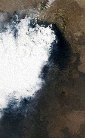
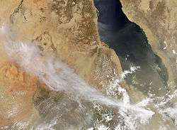
Natural-color satellite image showing a close-up view of the volcanic plume and eruption site on June 24, 2011. | |
| Volcano | Nabro Volcano |
| Date | June 2011 |
| Type | est. Strombolian/Vulcanian/Plinian |
| Location |
Eritrea, Africa 13°22′N 41°41′E / 13.36°N 41.69°ECoordinates: 13°22′N 41°41′E / 13.36°N 41.69°E |
| VEI | est. 3-4 |
| Impact | at least 7 people killed; ash deposited on at least 8 villages in Ethiopia and Eritrea, including Mekele and Asmara; lava flow reached 1 km wide by 20 km long |
The 2011 Nabro eruption was an eruption of the Nabro stratovolcano in the Southern Red Sea Region of Eritrea, which began on 12 June 2011 after a series of earthquakes.[1] The eruption killed seven[2] and possibly a further 31 people[3] and is estimated to be the highest altitude injection of sulfur dioxide (SO2) ever observed by satellite. The Mount Pinatubo eruption 20 years earlier emitted ten times more SO2.[4] The ash cloud from the eruption reached altitudes which disrupted airline traffic in the region.[5] Until the eruption began, the volcano had no records of historical eruptions.[6]
Gallery
-
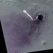
False color image from 19 June 2011 showing extent of lava flow on that date.
-
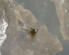
True color image from 19 June 2011 showing area affected by tephra deposition, and international boundaries.
-
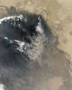
Natural color satellite view of the volcano on the 29th of June, 2011.
Eruption
Satellite images showed a large volcanic eruption occurring shortly after 22.00 UTC 12 June (close to 01.00 13 June local time), in the Southern Red Sea Region. It was first thought to have originated at Dubbi Volcano, but has been confirmed to be from the Nabro[7][8][9] stratovolcano in Eritrea, near the Ethiopian border.[10][11][12]
On 17 June, the Volcanic Ash Advisory Center (VAAC) reported that the eruption had ceased, but NASA's Aqua satellite passed overhead providing MODIS images on the 18th (at noon, local time) which showed an ash plume heading in west-north-westerly direction.[13]
On 19 June, the volcano produced the highest level of sulfur dioxide emissions in the earth's atmosphere ever detected from space.[4] Satellite images showed a 15 km long lava flow.[14] On 20 June, VAAC reported that the SO2 eruption was continuing.[15]
From 22 June to 27 June, the eruption of sulfur dioxide, water vapour, and ash was confirmed to be still active by MODIS pictures taken from the TERRA satellite.[16][17]
24 June NASA Earth Observatory provided this false-color image (below) using the Advanced Land imager on the EO-1 satellite, showing that the lava flow from the 19th had not progressed significantly further, but that the eruption was ongoing.
30 June, at least some of the people who have been evacuated are reported to be in Hawra and Wadien.[18]
On 30 June, eruption satellite images seem to show the volcano has stopped producing the ash cloud, but 1 July they show a fresh ash cloud eruption, diminishing until 4 July, when the ash eruption still appears to be ongoing,[19] but by 6 July the ash cloud seems to have stopped being produced again.
12 July: The eruption was still ongoing though the SO2 emissions were much reduced after 7 July [20]
Other eruptions
Small eruptions were also reported in the Afambo and Sireru[2] areas.[21]
On 22 June, the Eritrean government reported a lava flow up to 1 kilometre (0.6 mi) wide and up to 15 metres (49 ft) high had surfaced in Seriru, southern Denkalia, and destroyed vegetation for a distance of about 20 kilometres (12 mi).[22]
On 30 June, the Eritrean government report suggested that the lava flow in Seriru had slowed to a speed of 20 metres (66 ft) per day. They also reported that in some places the flow was 4 kilometres (2.5 mi) wide and 20 metres (66 ft) high.[18]
Note: It is still uncertain whether the information regarding the lava flow in "Seriru" refers to the main flow, as seen from the satellite images, though it seems likely.
A thick emission of smoke from new lava eruptions on 27 June were also reported in South Denkalia, Husele and Gagun.[18]
Ash cloud
The eruption has ejected a large ash cloud near the Eritrea–Ethiopia border region, extending over 1,000 km (620 mi) into neighboring Sudan.[23]
The height of the ash cloud peaked at 14,000 m,[24] implying a VEI of 3 or 4.
Forecasters predicted correctly[25] that the ash plume might reach Israel,[26] but no flights were cancelled at Ben-Gurion Airport on 14 June.[25] Elsewhere, however, the ash cloud began disrupting air traffic on 14 June with UAE-based Emirates flights being cancelled;[27] flights disruptions extended to other companies the following day.[28] Hillary Clinton, Secretary of State for the United States, shortened her state visit to Ethiopia. Djibouti Airport was closed, and several airlines suspended flights to Ethiopia.[5]
Mek'ele and Asmara were partially covered by volcanic ash.[29]
Effects
On 16 June, the inhabitants of Afambo, Nebro, and Sireru were evacuated.[30]
By 19 June, ash had been deposited at least 60 km (37 mi) beyond the Ethiopian border in a WNW–to–SSW direction.[4]
By 20 June, eight villages in the Biddu district of Ethiopia were covered by volcanic ash, affecting at least 5,000 people and polluting springs and streams. One entire community has not been heard from. Save the Children reports many community members, especially children, are sick and in desperate need of medical attention. Vomiting and retching were reported as being common effects.[31]
On 21 June, an Eritrean government statement reported seven people have been killed and three injured.[2][32] It was also reported that the Lake Afrera salt deposits now contain sulfuric acid, making the salt inedible.[21]
On 6 July, reports suggest 48,000 people in the Bidu, Afdera, Erebti, Elidar, Teru and Kori woredas were in need of aid (with ash affecting food and water sources), and that the casualty total had reached 31 dead in the Bidu woreda.[3]
Another 167,153 people, in the Elidar and Kori woredas, were reported as requiring monitoring according to the Afar regional government. However a spokesman for the Ethiopean Government Agriculture Ministry is reported to have said "We have looked at the document and I would like to make it clear that it is not a national document and that we have not endorsed it, the ministry has no record of casualties, it is still too early to say how many people had been affected and needed help." [3]
Geology
The erupting volcano is in the Afar Triangle, in the larger Danakil Depression that holds many other active volcanoes. However, neither volcano thought potentially responsible for the eruption had been active in the past century, with Dubbi last erupting in 1861 and Nabro remaining quiet for thousands of years. No eruption of Nabro occurred before in recorded history.[6] Basalt, trachyte and rhyolite are among the rock types which Nabro has produced as lava flows and pyroclastics.[33]
Earthquakes
The 2011 Eritrea–Ethiopia region earthquakes are an ongoing series of moderate earthquakes near a sparsely populated part of the Eritrea–Ethiopia border, starting at 15:37 UTC on Sunday, 12 June 2011. As of 21:37 UTC, at least 19 earthquakes of magnitude 4.5 or greater have occurred in the region.[34] The tremors were associated with this eruption.[35] The initial quake registered a magnitude of 5.1 Mw with a focal depth of 10 km (6.2 mi), and was succeeded by multiple lighter tremors. Hours later, two consecutive magnitude 5.7 Mw earthquakes struck the region at 20:32 and 21:03 UTC, occurring at very similar depths.[36] The latter tremors resulted in localized strong shaking, registering at VII (very strong) on the Mercalli scale near the epicenters.[37] Though no damage has been reported, there is concern over the cause of these earthquakes.
References
| Wikimedia Commons has media related to 2011 Nabro Eruption. |
- ↑ A, Solomon (13 June 2011). "Series of moderate earthquakes hit Eritrea – Ethiopia border region". Ethiopian Journal. Retrieved 13 June 2011.
- 1 2 3 "Volcanic Eruption in Southern Red Sea Region creates new landmass". 21 June 2011.
- 1 2 3 "ERITREA-ETHIOPIA: Thousands need aid after volcano eruption". 6 July 2011.
- 1 2 3 NASA Goddard Space Flight Center. "A-train observations of Nabro (Eritrea) eruption". nasa.gov.
- 1 2 Heinlein, Peter (14 June 2011). "Eritrea Volcano Disrupts East Africa Air Travel". Voice of America. Archived from the original on 15 June 2011. Retrieved 15 June 2011.
- 1 2 "Eruption at Nabro Volcano, Eritrea", NASA Earth Observatory. 13 June 2011. Accessed 13 June 2011
- ↑ Vervaeck, Armand (13 June 2011). "Eritrea volcano eruption : Ash cloud advisory extending further into Africa". Earthquake – Report. Retrieved 13 June 2011.
- ↑ Gubin, Anastasia (13 June 2011). "Africa: Volcán Nabro erupciona lanzando cenizas hasta Sudán". La Gran Época (in Spanish). Retrieved 13 June 2011.
- ↑ "Eruption at Nabro Volcano". 17 June 2011.
- ↑ Channel 6 news. BNO Newstitle=VAAC: Eruption underway at Dubbi volcano in Eritrea. 13 June 2011 http://channel6newsonline.com/2011/06/vaac-eruption-underway-at-dubbi-volcano-in-eritrea/. Archived from the original on 23 July 2011. Retrieved 13 June 2011. Missing or empty
|title=(help) - ↑ WireUpdate. BNO Newstitle=UPDATE 1 – Volcanic eruption in Eritrea sends plume into the air, first since 1861. 13 June 2011 http://wireupdate.com/wires/18119/update-1-volcanic-eruption-in-eritrea-sends-plume-into-the-air-first-since-1861/. Retrieved 13 June 2011. Missing or empty
|title=(help) - ↑ VAAC, Toulouse. "Toulouse VAAC – Volcanic Ash Advisories". Meteo France. Toulouse Volcano Ash Advisory Centre. Retrieved 13 June 2011.
- ↑ "Satellite Image Shows Nabro Volcano Eruption Is Ongoing". 18 June 2011.
- ↑ "Zusammenfassung: Nabro, Puyehue, und diverse Erdbeben" (in German). 23 June 2011.
- ↑ "Toulouse VAAC". 20 June 2011.
- ↑ "SO2, Ash Emissions From Nabro Volcano Drift Over Ethiopia". 23 June 2011.
- ↑ "Nasa Terra MODIS image". 27 June 2011.
- 1 2 3 "No accident witnessed on human or animal lives, Say displaced inhabitant of Sireru". 30 June 2011.
- ↑ "Nasa Lance-modis image". 4 July 2011.
- ↑ "NASA SO2 images for Afar and southern Red Sea". July 2011.
- 1 2 "Eritrean Volcano erupts economic mayhem for Ethiopia". 12 June 2011.
- ↑ "Government Taking Close Care Of Nationals Affected By Earthquake And Volcanic Eruption". 22 June 2011.
- ↑ Duran, Jim; Warren Miller (13 June 2011). "Dubbi volcanic ash cloud expands westward through Northern Africa". The Weather Space. Retrieved 13 June 2011.
- ↑ "Eruption at Nabro Volcano". Archived from the original on 30 June 2011. Retrieved 2011-06-20.
- 1 2 "Ash cloud from Eritrean volcano reaches Israel". 14 June 2011.
- ↑ Masa, Israel. "ענן וולקני מהר געש באריתריאה מתקדם לעבר ישראל" (in Hebrew). Masa.co.il. Archived from the original on 24 July 2011. Retrieved 13 June 2011.
- ↑ "Emirates flights to Africa disrupted", Dubai Chronicle 14 June 2011. Accessed 14 June 2011
- ↑ Cathy Buyck (15 June 2011). "Nabro volcano eruption affects flights in Northeast Africa". Air Transport World. Retrieved 24 June 2011.
- ↑ "Nabro: Annulation de vols en Erythrée" (in French). 14 June 2011.
- ↑ "Inhabitants of Afambo, Nebro and Sireru moved to safer locations". 16 June 2011.
- ↑ "Eritrea volcano ash hits Ethiopia villagers". BBC News. 20 June 2011.
- ↑ "First video from the eruption at the Eritrean side of the border". 21 June 2011.
- ↑ http://www.volcano.si.edu/world/volcano.cfm?vnum=0201-101
- ↑ "Map Zoom - LAT: 10 - 20 ; LON: 36 - 46". EMSC. 18 June 2011. Retrieved 2011-06-18.
- ↑ Stuff, NZ (13 June 2011). "Quake swarm hits Ethiopia-Eritrea". Stuff.co.nz. Retrieved 13 June 2011.
- ↑ "Earthquake List for 10-degree Map Centered at 10°N, 45°E". USGS. 18 June 2011. Retrieved 2011-06-18.
- ↑ "Magnitude 5.7 – Eritrea - Ethiopia Region". USGS. 12 June 2011. Retrieved 12 June 2011.