Aïn Oulmene
| Aïn Oulmene عين اولمان Zaraï | |
|---|---|
| Commune and town | |
|
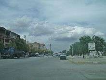
Ain-Oulmène, Algeria | |
| Nickname(s): Henshir Zaria | |
 | |
| Country |
|
| Province | Sétif Province |
| District | Aïn Oulmane District |
| Area | |
| • Total | 200 sq mi (530 km2) |
| Elevation | 3,120 ft (950 m) |
| Population (1998)[1] | |
| • Total | 73,831 |
| • Density | 360/sq mi (139/km2) |
| Time zone | CET (UTC+1) |
| Area code(s) | 1928 |

Aïn Oulmene is a town and commune in Sétif Province in north-eastern Algeria.[2][3]
During the Roman Empire the small city was called Zarai.
Geography
It is the capital of the Aïn Oulmene county, located at an altitude of 950 m, on the RN 28 to 30km southwest of Setif, close to the high fertile plains south of Setif and to the west, the mountains of Hodna. Its terrain is generally flat in its eastern part, while its western part is occupied by small mountains which is the highest Osman Jebel which culminates at 1100 meters. The town has 73 831 inhabitants at the census in 2008.
History
The indigenous inhabitants of Aïn Oulmene are original the Zenata and Sanhadja, berber tribes.
The Romans settled in 'to Zarai' (Zraïa) during the reign of Hadrian (117-138 AD.) and the nearby Setif colony was founded by Nerva (96-98 AD). The 1st Flavia Equilata or 6th Commagenorum were stationed here. Stéphane Gsell who undertook excavations in the area in the early 20th century. The city has a Roman and Byzantine era necropolis.
In the 8th century, Okba Ibn Nafaa installed a garrison near here.
Aïn Oulmene was from 1880 to 1958, the capital of the mixed town of Rirha (pronounced "ryɣa"). The name of Aïn Oulmene appeared for the first time in 1887 on an administrative documents. Aïn Oulmene was known as Colbert by the French from 1887 and was capital of the commune from 1935 to 1962. The name "Aïn Oulmene" reappear in 1962 with the independence of Algeria.
Toponymy
The place derives its name from the Arabic ain ( "source"), and Berber Oulmane ( "son to weave"). The full name of the town means therefore the source of weaving son.[4]
The name could also mean "Fountain Elms" because according to Arthur Pellegrin (Toponymy of Algeria. March 1952), "oulmen" is the plural of "Oulmou 'meaning elm in Berber and that would itself from the Latin" Ulmus ". It is remarkable that the "Oulme" root derived from the Latin word has been the cause of several names, including " Oulmes " in Morocco, L'Houmeau, the Houme in France.[5]
Aïn Oulmene is also known as عين اولمان in Arabic and 3ⵢⵏⵓⵍⵎⴰⵏ in Berber.
Economy
Aïn Oulmene is located in an agricultural vocation region. cereals were cultivated and vegetables but after the drought of the last quarter century tobacco farming, raising livestock and poultry are more popular.
Sports
The town has a football club ESAO (eg ESC) founded in 1927 which carries the colors blue and white. There is a boxing club and Female Handball club which represented Algeria in various international competitions.
Personalities linked to
- Jean Baptiste Mattei , 1898–1980, born in Corti, doctor by profession. He moved to Algeria in 1927, First Mayor (Socialist) Colbert (Ain-Oulmène) from 1928 to 1937 and colonial doctor in New Caledonia in 1938. He joined the Free Franch in 1940, he was appointed Chief Resident the Wallis and Futuna archipelago from 1942 to 1945. in 1947, he was appointed District Director of Health in Algiers, a position he held until 1965. Died in Bastia in 1980.
- Djamila Debbeche, born in 1921 in the region of Aïn Oulmene (ex. Colbert) [precision needed], a pioneer in French language Algerian women's literature. Author of the novel "Leila girl in Algeria" published in 1947.
- Noureddine Aba, born February 16, 1921 in Aïn Oulmene (ex. Colbert), poet, storyteller, playwright, creator in 1991 of the Aba Foundation awarding prizes to the best writers of the year.
- Abdelwahab Hammoudi, born in 1955 in Ain Oulmène ex Colbert. Filmmaker, novelist and essayist.
- Azzedine Djellaoudji , Arabic poet and novelist.
- Sofiane Mokhenache, author Arabic novelist of the novel "لا يترك في متناول الأطفال".
- Bassem Debbabi, Doctor in Computer Engineering from the University of Grenoble. Three times champion of Algeria in Computer Science (2000, 2001 and 2002).
References
- ↑ Wilaya de Sétif : répartition de la population résidente des ménages ordinaires et collectifs, selon la commune de résidence et la disp Archived March 3, 2016, at the Wayback Machine..
- ↑ "Communes of Algeria". Statoids. Archived from the original on 29 November 2010. Retrieved December 12, 2010.
- ↑ Achour Cheurfi, Dictionary Algerian localities Casbah Editions, Algiers, 2011
- ↑ Foudil Cheriguen, Toponymie algérienne des lieux habités (les noms composés), Alger, Épigraphe, 1993, p. 72, 76.
- ↑ Pellegrin, Arthur (15 March 1952). Toponymie de l'Algérie. Algiers: Société nationale des entreprises de presse.

Coordinates: 35°55′N 5°18′E / 35.917°N 5.300°E