A12 motorway (Netherlands)
| |
|---|---|
| Rijksweg 12 | |
|
Location of the A12 motorway | |
| Major junctions | |
| West end: | The Hague |
| East end: | Lobith |
| Location | |
| Provinces: | South Holland, Utrecht, Gelderland |
| Highway system | |
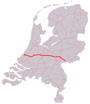
The A12 motorway is a motorway in the Netherlands. The road connects the city of The Hague with the German border, near Zevenaar, and the German Autobahn BAB 3. On its way, it crosses three Dutch provinces: South Holland, Utrecht, and Gelderland.
European routes
The A12 motorway runs along with parts of three major European routes:
- The European route E30 follows the A12 between interchange Prins Clausplein near The Hague, and interchange Lunetten, just southeast of the city of Utrecht.
- The European route E25 runs along the A12 between interchange Gouwe near Gouda, and interchange Oudenrijn, just southwest of Utrecht.
- The European route E35 follows the route of the A12 from interchange Oudenrijn towards the German border.
The A12 near The Hague

The section of the A12 road within the city of The Hague (near exits 1, 2 and 3) is actually not a motorway, but a highway. This part of the road, known as the Utrechtsebaan, is too narrow to meet the Dutch requirements for a motorway (for example, it does not have a shoulder), and is therefore a highway with a maximum speed of 70 km/h.
To avoid local traffic from using this heavily congested part of the road, exits 2 through 4 are built as incomplete exits. These exits only feature westbound exits and eastbound entrances, so they can only be used by interlocal traffic. Local traffic is therefore forced to make use of the available local roads.
'Branding' controversy
In 2008, a government programme on route branding, under an umbrella project in urban planning, put stickers on all streetlights of the A12, citing efforts to give it a "route 66-like" allure. This plan, dubbed the "regenboogroute" (rainbow route), received news coverage because of its alleged trivial results (stickers on streetlights) and high costs (€120 000).[1]
Exit list
| Country | Province | Municipality | km | mi | Exit | Destinations | Notes |
|---|---|---|---|---|---|---|---|
| The Netherlands | South Holland | The Hague | 1 | 0.62 | 1 | ||
| 2 | 1.2 | 2 | Juliana van Stolberglaan / Prins Bernhardviaduct | Westbound exit and eastbound entrance | |||
| The Hague / Leidschendam-Voorburg municipality line | 3 | 1.9 | 3 | Schenkkade | Westbound exit and eastbound entrance only | ||
| Leidschendam-Voorburg | 5 | 3.1 | 4 | Westbound exit and eastbound entrance only | |||
| The Hague | 6 | 3.7 | — | West end of E 30 overlap | |||
| 7 | 4.3 | 5 | Donau / Koning Willem-Alexanderviaduct | ||||
| Zoetermeer | 13 | 8.1 | 6 | Zuidweg / Afrikaweg | Eastbound exit and westbound entrance only | ||
| 16 | 9.9 | 7 | |||||
| Lansingerland | 18 | 11 | 8 | ||||
| Zuidplas | 23 | 14 | 9 | ||||
| Waddinxveen | 27 | 17 | — | West end of E 25 overlap; eastbound entrance and westbound exit only | |||
| 29 | 18 | 11 | |||||
| Bodegraven-Reeuwijk | 33 | 21 | 12 | ||||
| 35 | 22 | 12a | Westbound exit and eastbound entrance only | ||||
| 39 | 24 | 13 | Molendijk / Verlengde Tuurluur | ||||
| Utrecht | Woerden | 46 | 29 | 14 | |||
| 51 | 32 | 14a | |||||
| Utrecht | 54 | 34 | 15 | ||||
| 57 | 35 | — | East end of E 25 overlap; west end of E 35 overlap | ||||
| 59 | 37 | 16 | Papendorpseweg | ||||
| Amsterdam–Rhine Canal | Galecopperbrug | ||||||
| Utrecht | Utrecht | 60 | 37 | 17 | Europalaan | ||
| 61 | 38 | 18 | |||||
| 62 | 39 | — | East end of E 30 overlap | ||||
| Bunnik | De Forten rest area Eastbound exit and entrance only | ||||||
| Bunnik | 68 | 42 | 19 | ||||
| Utrechtse Heuvelrug | 71 | 44 | 20 | ||||
| 77 | 48 | 21 | Eastbound exit and westbound entrance only | ||||
| 81 | 50 | 22 | |||||
| Bloemheuvel rest area eastbound Oudenhorst rest area westbound | |||||||
| Renswoude / Veenendaal municipality line | 92 | 57 | 23 | ||||
| Utrecht / Gelderland province line | Veenendaal / Ede municipality line | 104 | 65 | 23a | |||
| Gelderland | Ede | 107 | 66 | — | |||
| 109 | 68 | 24 | |||||
| Buunderkamp rest area eastbound 't Ginkelse Zand rest area westbound | |||||||
| 120 | 75 | 25 | |||||
| Arnhem | 121 | 75 | — | West end of A50 overlap | |||
| De Schaars rest area Westbound exit and entrance only | |||||||
| 128 | 80 | — | East end of A50 overlap | ||||
| 129 | 80 | 26 | |||||
| 134 | 83 | — | |||||
| IJssel | IJsselbrug | ||||||
| Gelderland | Duiven | 136 | 85 | 27 | |||
| 138 | 86 | 28 | |||||
| Oudbroeken rest area eastbound Aalburgen rest area westbound | |||||||
| Zevenaar | 143 | 89 | 29 | ||||
| 147 | 91 | — | Eastbound exit and westbound entrance only | ||||
| 149 | 93 | 30 | |||||
| 2theloo rest area Northbound exit and entrance only | |||||||
| — | Border with Germany; this road continues as the German A 3; east end of E 35 overlap | ||||||
1.000 mi = 1.609 km; 1.000 km = 0.621 mi
| |||||||
References
| Wikimedia Commons has media related to Rijksweg 12. |