Zevenaar
| Zevenaar | |||
|---|---|---|---|
| City and municipality | |||
|
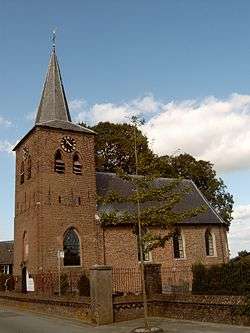
Church in Lathum | |||
| |||
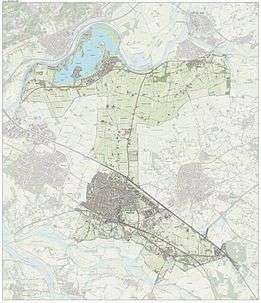
.svg.png) Location in Gelderland | |||
| Coordinates: 51°55′N 6°4′E / 51.917°N 6.067°ECoordinates: 51°55′N 6°4′E / 51.917°N 6.067°E | |||
| Country | Netherlands | ||
| Province | Gelderland | ||
| Government[1] | |||
| • Body | Municipal council | ||
| • Mayor | Jan de Ruiter (PvdA) | ||
| Area[2] | |||
| • Total | 58.00 km2 (22.39 sq mi) | ||
| • Land | 53.26 km2 (20.56 sq mi) | ||
| • Water | 4.74 km2 (1.83 sq mi) | ||
| Elevation[3] | 12 m (39 ft) | ||
| Population (May 2014)[4] | |||
| • Total | 32,282 | ||
| • Density | 606/km2 (1,570/sq mi) | ||
| Demonym(s) | Zevenaarder | ||
| Time zone | CET (UTC+1) | ||
| • Summer (DST) | CEST (UTC+2) | ||
| Postcode | 6900–6909, 6986–6988 | ||
| Area code | 0313, 0316 | ||
| Website |
www | ||
Zevenaar (![]() pronunciation ) is a municipality and a city in the Gelderland province, in the eastern Netherlands near the border with Germany.
pronunciation ) is a municipality and a city in the Gelderland province, in the eastern Netherlands near the border with Germany.
Population centres
- Angerlo
- Babberich
- Giesbeek
- Lathum
- Ooij or Ooy
- Oud-Zevenaar
- Zevenaar
History
The earliest signs of human activity are remnants of a 700 BC settlement found near present-day Zevenaar. In 1049, Emperor Hendrik III donated a large amount of land to five warlords of which the leader was named Bartholomeus II of Sevenaer. They founded a castle to protect the old Roman settlements from the Germans.
In 1487, the duke of Cleves, a nearby town in Germany, gave Sevenaer city rights. Sevenaer was an important strategic point on the border of Gelderland and Germany. Some of the Castles and houses in Zevenaar have foundations dating back to the 14th Century Huize Sevenaer.
When Sevenaer obtained city rights it had the monopoly on markets and on sale of bread and beer with the surrounding towns. Also the jurisdiction in Sevenaer was founded, the town government was charging taxes so that the town could build roads, railways and public buildings. For the 500 inhabitants that was a heavy tax. Because of the plundering by several armies there were not enough supplies and money to build anything. Also contagious diseases ensured much embarrassment. In that time not the citizens but some well-to-do families got the right to participation in policy and government. Sevenaer then experienced a prosperous period. In 1793 the city had 900 inhabitants.
In 1816, Sevenaer became part of the Kingdom of the Netherlands. Two years later the old spelling of Sevenaer was changed to the current name: Zevenaar. The municipality then had 2564 inhabitants. The 19th century was a century of poverty, bad harvests, sicknesses and hunger. There was hardly trade and work. Many people lived by agriculture or from charity. In 1856, Zevenaar was connected to the European railroad system, which (just some decades later) led to the increase in workforce. In 1920, the cigarette factory Turmac came which insured much employment.
After the second World War, which caused a lot of damage, people started to rebuild and new residential areas arose around the old core. In the 1950s approximately 10,000 people lived in Zevenaar. By 2005, that number had more than doubled to 22,500 inhabitants. The municipality of Zevenaar exists of the following residential areas: Angerlo, Babberich, Giesbeek, Lathum, Ooy, Old Zevenaar, and Zevenaar, which together have 31.840 inhabitants in January 2007.(source: CBS)
Notable residents
- Phillip Cocu (born 1970), footballer
- Karel de Nerée tot Babberich (1880-1909), symbolist artist
- Esmée Denters (born 1988), female singer
- Ruud Knol (born 1981), footballer
- Andreas Masius (1514-1573), Catholic priest, humanist and European scholar
- Erik Parlevliet (1964-2007), hockey player
- Linda Wagenmakers (born 1975), musical star
- H. L. M. van Nispen van Sevenaer (1879-1958), mayor of Laren and Blaricum, co founder of singer museum and resistance fighter
Image gallery
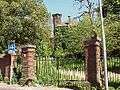 Castle Sevenaer
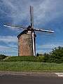 Zevenaar, windmil: de Buitenmolen
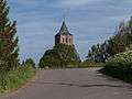 Oud-Zevenaar
References
- ↑ "College van B&W" [Board of mayor and aldermen] (in Dutch). Gemeente Zevenaar. Retrieved 24 July 2014.
- ↑ "Kerncijfers wijken en buurten" [Key figures for neighbourhoods]. CBS Statline (in Dutch). CBS. 2 July 2013. Retrieved 12 March 2014.
- ↑ "Postcodetool for 6901AA". Actueel Hoogtebestand Nederland (in Dutch). Het Waterschapshuis. Retrieved 24 July 2014.
- ↑ "Bevolkingsontwikkeling; regio per maand" [Population growth; regions per month]. CBS Statline (in Dutch). CBS. 26 June 2014. Retrieved 24 July 2014.
External links
 Media related to Zevenaar at Wikimedia Commons
- Official website
 |
Rheden, Doesburg | Bronckhorst | | |
| Westervoort Duiven |
|
Doetinchem Montferland | ||
| ||||
| | ||||
| Rijnwaarden | Emmerich am Rhein (DE-NW) |
