Actopan, Hidalgo
| Actopan | |
|---|---|
| Municipality and city | |
 | |
|
Actopan Location in Mexico | |
| Coordinates: 20°16′12″N 98°56′42″W / 20.27000°N 98.94500°W | |
| Country |
|
| State | Hidalgo |
| Municipal seat | Actopan |
| Area | |
| • Total | 280.1 km2 (108.1 sq mi) |
| Population (2005) | |
| • Total | 48,518 |
Actopan (Otomi: Ma’ñuts’i) s a city and one of the 84 municipalities of Hidalgo, in central-eastern Mexico. The municipality covers an area of 280.1 km². It is crossed by the federal road that runs from Mexico City to Nuevo Laredo and it is located 30 km northwest of Pachuca, the capital city of the state of Hidalgo.
Actopan is known as the city of the convent and the land of the barbecue. Its name derives from the word “Atoctli” meaning “firm, fertile, and humid land” and the word “pan” meaning “on” or “over” in Nahuatl. Thus, the name Actopan comes to mean “on the firm, humid, and fertile land”.[1]
Actopan’s original name in Otomi is “Mañutzi” which translates to “my little pathway”.[2]
History

It is estimated that the Toltecas arrived to an area close to Actopan in 674. By the year 1117, another indigenous group called the Chichimecas arrived to what is now Actopan and Mixquiahuila. In 1113, Xide gave Actopan the name “Mañutzi”. Actopan was under the rule of the chichimecas until the emperor Moctezuma II added the area that is now Actopan to his dominion. In 1521, the indigenous Otomies helped the leader Cuauhtémoc defend Mexico against Spanish colonizers.
Juan Gonzalez Ponce de Leon was one of the first Spaniards given encomendero status over Actopan in the early 1520s.[3]
The movement to convert the population to Roman Catholicism begin in 1526 with the Augustine Friars. By the year 1548 the temple and monastery in Actopan had already been built. It was declared a historic and artistic monument on February 2, 1933.
In 1531 Actopan was put under the jurisdiction of the corregidor of Iscuincuitlapilco. By 1568 it was made a separate jurisdiction with its own alcaldia mayor. Yolotepec was also within these domains. As of 1791 the population consisted of 20,000 Indios, 2,291 mestizos, 54 pardos and 1,474 Spaniards (this would be both creolles and peninsulares, and probably included some people with some indigenous ancestry).[4]
Actopan now consist of more than 20 communities, most of which names derive from the Otomi language.[5]
Chronology of Important Dates
1546- Actopan’s founding year.
1865- The state of Hidalgo is divided into 3 departments: Huejutla, Tulancingo and Tula.
1868- The then president of Mexico, Benito Juarez, created the state of Hidalgo.
1946- On May 10, Actopan was declared a city. [5]
Climate
| Climate data for Actopan | |||||||||||||
|---|---|---|---|---|---|---|---|---|---|---|---|---|---|
| Month | Jan | Feb | Mar | Apr | May | Jun | Jul | Aug | Sep | Oct | Nov | Dec | Year |
| Average high °C (°F) | 22.3 (72.1) |
24.2 (75.6) |
27.1 (80.8) |
28.6 (83.5) |
28.7 (83.7) |
26.5 (79.7) |
25 (77) |
25.2 (77.4) |
24.3 (75.7) |
23.7 (74.7) |
23.1 (73.6) |
22.4 (72.3) |
25.1 (77.2) |
| Average low °C (°F) | 3 (37.4) |
4 (39) |
6 (43) |
8.6 (47.5) |
10.1 (50.2) |
11.3 (52.3) |
10.9 (51.6) |
10.8 (51.4) |
10.8 (51.4) |
8.6 (47.5) |
5.5 (41.9) |
3.7 (38.7) |
8 (46) |
| Average precipitation mm (inches) | 10 (0.4) |
5 (0.2) |
10 (0.4) |
28 (1.1) |
41 (1.6) |
66 (2.6) |
64 (2.5) |
50 (2) |
64 (2.5) |
38 (1.5) |
10 (0.4) |
5 (0.2) |
391 (15.4) |
| Source: Weatherbase [6] | |||||||||||||
Sites of Interest
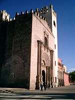
San Nicolás Tolentino Temple and Ex-Monastery: This colonial building was built in 1546 under the direction of the Augustine Friars. The temple and ex-convent combine elements from the romantic, gothic and renaissance periods. Data from the year 1548 points to Frail Andres de Mata as the person in charge of the construction of the monument. The richness of the monument lies in the still-conserved mural paintings. The San Nicolas de Tolentino Temple and Ex-Monastery were declared a historic and artistic monument on February 2, 1933. It is located in the center of the city.[7]
Puente De Dios: The site “Puente De Dios” is a natural attraction located in the northern part of the city. It is the product of an erosion from the Magdalena River. There is a pathway in the site for pedestrians and bikers to enjoy the flora and fauna found there.[8]
Mirador del Obelisco: The mirador del obelisco is a slender stone pyramid. It was built as a commemoration to Mexico’s Bicentennial Independence Day celebration. It is known to be the fifth tallest obelisk in the world.[8]
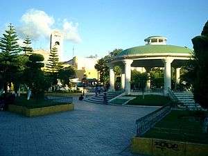
La Eroca: It is the biggest and most beautiful park in Actopan. The park has space for sport activities, an area for grilling, a pool, and public restrooms.[8]
Food and Culture
.JPG)
- Foods:
Actopan is a city full of culture and exquisite foods. It is known for its authentic barbecue dish. Unlike the typical beef barbecue, “Actopan-style” barbecue consist of sheep meat slowly cooked in an underground grill. Aside from this dish, other traditional dishes include: mole, ximbo, mixiotes, traditional candy, cheese, and pulque.[9]
- Celebrations:
The two main festivities in Actopan are the celebration in honor of the San Nicolas de Tolentino patron that takes place on July 8. This religious celebration include the use of mechanical games and castles that produce fireworks. Another important festivity is the Day of the Dead celebration. During this holiday relatives bring flowers and food to their loved ones in the cemetery.[10]
Current Facts
As of 2005, the municipality had a total population of 48,518.[11] About 1800 residents of the total population speak an indigenous language, mainly otomi. The principal religion is Roman Catholicism.[12]
References
- ↑ http://www.actopan.mx
- ↑ http://www.actopan.info/actopan/toponimia.shtml
- ↑ Peter Gerhard, Guide to the Historical Geography of New Spain (Cambridge: Cambridge University Press, 1972) p. 44
- ↑ Gerhard, Guide to New Spain, p. 44-45
- 1 2 http://www.actopan.info/actopan/historia.shtml
- ↑ "Weatherbase: Historical Weather for Actopan, Hidalgo". Weatherbase. 2011. Retrieved on November 24, 2011.
- ↑ http://actopan.hidalgo09.over-blog.es/pages/MONUMENTO_HISTORICO-1487122.html
- 1 2 3 http://actopan.hidalgo09.over-blog.es/pages/ATRACTIVOS_NATURALES_DE_ACTOPAN-1487030.html
- ↑ http://www.actopan.info/actopan/cultura.shtml
- ↑ http://www.actopan.info/actopan/cultura.shtm
- ↑ "Actopan". Enciclopedia de los Municipios de México. Instituto Nacional para el Federalismo y el Desarrollo Municipal. Retrieved December 27, 2008.
- ↑ http://www.actopan.info/actopan/datos_generales.shtml

Coordinates: 20°16′01″N 98°55′59″W / 20.267°N 98.933°W