Aguada, Puerto Rico
| Aguada, Isla Encantada | |||
|---|---|---|---|
| Municipality | |||
|
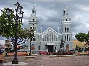
The main plaza and the Catholic Church of Aguada | |||
| |||
| Nickname(s): "La Villa de Sotomayor", "Ciudad Del Descubrimiento", "Villa de San Francisco de Asís de la Aguada", "El Pueblo Playero", "La Ciudad del Vaticano" | |||
| Anthem: "Muchos siglos han pasado" | |||
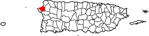 Location of Aguada in Puerto Rico | |||
| Coordinates: 18°22′46″N 67°11′18″W / 18.37944°N 67.18833°WCoordinates: 18°22′46″N 67°11′18″W / 18.37944°N 67.18833°W | |||
| Country |
| ||
| Territory |
| ||
| Founded | 1508 | ||
| Government | |||
| • Mayor | Jessie Cortés Ramos (PPD) | ||
| • Senatorial dist. | 4 - Mayagüez | ||
| • Representative dist. | 18 | ||
| Population (2010[1]) | |||
| • Total | 41,959 | ||
| Demonym(s) | Aguadeños | ||
| Time zone | AST (UTC-4) | ||
| Zip code | 00602 | ||
| Website | aguada.gov.pr | ||
Aguada (/əˈɡwɑːdə/; Spanish: [aˈɣwaða], Watered) is a municipality of Puerto Rico, located in the western coastal valley region bordering the Atlantic Ocean, east of Rincón, west of Aguadilla and Moca; and north of Anasco and Mayaguez. It is part of the Aguadilla-Isabela-San Sebastián Metropolitan Statistical Area. Aguada's population is spread over 17 wards and Aguada Pueblo, which is the downtown area and the administrative center of the city.
History
According to sources, a Taíno settlement called Aymamón was located close to the Culebrinas River.[2] Although there is dispute to it, some sources believe that Christopher Columbus entered the island of Puerto Rico through Aguada on his second voyage in November 1493.[3][4] The nearby city of Aguadilla also claims to be the site of Columbus' arrival. While there is no specific historical proof, it is known that many of the first attempts to set up a town on the island were in Aguada.
In July 1510, Cristóbal de Sotomayor received control of the area from Juan Ponce de León and renamed the town Villa de Sotomayor. [5] However, in 1511 the settlement was attacked and burned by the local Taínos. That same year, the King ordered a monastery established in the island, and the Ermita de Espinar was founded. The name of the region was then changed to San Francisco de Asís de la Aguada, since the friars were Franciscan. The monastery was finished in 1516. In 1526, King Charles I of Spain officially founded the Aguada settlement. However, in 1529, Taínos attacked the monastery killing the friars and burning the settlement.[6]
Still, Aguada resurfaced and became a stopover point for ships on their way to Spain from South America. In September 17, 1662, King Charles II of Spain emitted a Royal Decree declaring Aguada as a "village", and assigning Juan López de Segura as First Lieutenant.[6]
On 1737, Philip V, King of Spain, declared that all mail en route to Venezuela and other South American countries from Puerto Rico must exit from Aguada's ports, leading to the area's economic growth. Also, an increase in population has been attributed to possible desertions from foreign merchant ships.
In the early years of the 20th Century, two disasters affected the town of Aguada. First, a huge fire in 1912 destroyed most of the town buildings, including the old city hall, which contained all the city archives. Also, an earthquake in 1918 destroyed the church and other structures.[7]
Geography
Aguada is located in the west coast of the island of Puerto Rico. It borders the Atlantic Ocean and Aguadilla on the north, Moca on the east, Añasco on the south, and Rincón on the west. Aguada is part of the Coastal Plains of the West, which features alluvial and fertile terrain. Although the terrain is mostly plain, there are some mountains to the south and southeast.[8]
Among the mountains located in Aguada are the Atalaya peak, located within the limits of Aguada and Rincón. Also, the San Francisco mountain, which is the birthpoint of the Cordillera Central, and Cerro Gordo, peaking at 260m (853 feet).[9]
Water features
Aguada's hydrographic system is composed of the Río Culebrinas, Caño Madre Vieja, Río Grande, Río Cañas, Río Culebra, Río Guayabo, and Río Ingenio. All of these rivers flow into the Mona Passage.[8]
Cityscape
Barrios
There are 19 "barrios" or wards in Aguada:
- Aguada Pueblo
- Asomante
- Atalaya
- Carrizal
- Cerro Gordo
- Cruces
- Espinar
- Guanábano
- Guaniquilla
- Guayabo
- Jagüey Chiquito
- Jagüey
- Lagunas
- Mal Paso
- Mamey
- Marías
- Naranjo
- Piedras Blancas
- Río Grande
Tourism
Aguada is part of the Porta del Sol touristic region in Puerto Rico. The Porta del Sol website highlights Aguada's town square and beaches as its most notable touristic attractions. It also mentions landmarks like the Espinar Hermitage Ruins[10] and a children playground.[11]
Another landmarks and places of interest in Aguada are:
- Aguada Museum located in a former railroad station building.
- Coloso Sugar Cane Refinery
- La Cruz de Culebrinas
- Pico de Piedra Beach
- Loma Linda Stables
- San Francisco de Asís Parish
- Aguada transmission station, the tallest man-made structure in Puerto Rico.
Culture
Some of the festivals and celebrations held in Aguada are:
- Noche de San Juan Festival - June
- Chopa Festival - August
- Juey Festival - October
- San Francisco de Asis Patron Festivities - October
- Artesans Fair - November
Also, every year in the month of November, a parade called "La Parada del Descubrimento" is celebrated to remember the discovery of Puerto Rico by Christopher Columbus. In this parade the people walk from the Catholic church in the town square to the Cross of Columbus next to the beach in Guaniquilla.[12]
Economy

The economy of Aguada was mostly based on the processing of sugarcane. The Central Coloso, located in the Guanábano ward of Aguada, was one of the most important refineries in the island. It was also the last one to cease operations, officially closing in 2003.[13]
Aside of sugar mills, there was also a cattle and wood industry established. As of 2012, the economy relies mostly on small businesses and manufacturing.[8]
Late in 2014, the government announced a $172 million deal with private investors to restart sugar production in Puerto Rico for the purpose of supplying the rum producers of the Island with up to 56% of their need for molasses. The plan involved building a new processing plant on the grounds of the old Coloso Sugar Cane factory in Aguada. [14]
Demographics
| Racial - (self-defined) Aguada, Puerto Rico - 2010 Census[15] | ||
|---|---|---|
| Race | Population | % of Total |
| White | 36,350 | 86.6% |
| Black/Afro Puerto Rican | 2,226 | 5.3% |
| Native Americans and Alaska Native | 129 | 0.3% |
| Asian | 22 | 0.1% |
| Native Hawaiian Pacific Islander | 0 | 0.0% |
| Some other race | 2,222 | 5.3% |
| Two or more races | 1,010 | 2.4% |
| Historical population | ||
|---|---|---|
| Year | Pop. | ±% |
| 1930 | 14,670 | — |
| 1940 | 17,923 | +22.2% |
| 1950 | 20,743 | +15.7% |
| 1960 | 23,234 | +12.0% |
| 1970 | 25,658 | +10.4% |
| 1980 | 31,567 | +23.0% |
| 1990 | 35,911 | +13.8% |
| 2000 | 42,042 | +17.1% |
| 2010 | 41,959 | −0.2% |
In 2010, the population of Aguada was 41,959, which represented a small decrease from the 42,042 registered in the 2000 Census.[16] This has been the first decrease in population in the last century. Aguada's population had been increasing steadily from 14,670 in 1930 to its current population.[17]
According to the 2010 Census, 86.6% of the population identifies themselves as White, and 5.3% as Black. Also, according to the census, the population is equally divided by gender (49.1% are males, while 50.1% are females). Finally, 23.7% of the population is under 18 years old. The next biggest percentage of population (20.8%) is between 35 and 49 years old.[18]
Government
Mayors
All municipalities in Puerto Rico are administered by a mayor, elected every four years. The current mayor of Aguada is Jessie Cortés Ramos, of the (PPD). He was elected at the 2012 general elections.
This is a list of registered and known mayors of Aguada, until present time.[19]
| Years | Mayor | Political Party |
|---|---|---|
| 1921 - 1928 | Manuel Ruiz Gonzalez | |
| 1928 - 1932 | Carlos Gonzalez | |
| 1932 - 1936 | Efigenio Charneco | |
| 1936 - 1940 | Femando Rivera | |
| 1940 - 1944 | Andres Carrero | |
| 1944 - 1948 | Juan Villarrubia Santiago | PPD |
| 1948 - 1960 | Manuel Egipciaco | PPD |
| 1960 - 1968 | Juan Figueroa Gonzalez | PPD |
| 1968 - 1972 | Julio C. Roman Gonzalez (Yuyo) | PNP |
| 1972 - 1976 | Mabel Velez de Acevedo | PPD |
| 1976 - 2000 | Julio C. Roman Gonzalez (Yuyo) | PNP |
| 2000 - 2004 | Miguel A. Ruiz Hernandez (Miguelito) | PPD |
| 2004 - 2012 | Luis A. Echevarria Santiago (Berty) | PNP |
| 2012–Present | Jessie Cortés Ramos | PPD |
Senate
The city belongs to the Puerto Rico Senatorial district IV, which is represented by two Senators. In 2012, María Teresa González and Gilberto Rodríguez were elected as District Senators.[20]
Symbols
Flag

Aguada's flag was designed by Pedro Vélez Adróvar. It features three main colors: white, red, and yellow. White represents purity and the waters of Culebrinas River. Over the white field, a blue triangle with a blue dove is featured. The dove is the symbol of peace that unites the towns. Red symbolizes the martyrdom of Franciscan friars from Espinal. Over the red field, there's a cross which represents the birth of Christianity in Puerto Rico. The name of "Aguada" is also above the cross. The yellow field represents happiness and hospitality of the residents. Over the yellow field, there's a star which symbolizes the hope of the town for more development and progress.[21]
Coat of Arms

The coat of arms is divided into two main fields. The upper field features a cross, with the interlaced arms of Christ and Father Saint Francis. It is taken from the badge of the Order of Friars Minor. It represents the motto "Pax et Bonum", which means "peace and good will between man and the Redeemer". The sun below the cross symbolizes the light that brightens the world. The lower part of the shield consists of five ships that symbolize the second voyage of Christopher Columbus, who allegedly arrived at the western "Guaniquilla" coast on November 19, 1493 to gather water. Although the precise location is disputed, the Aguada wells is a plausible site for the actual event.
The mural crown in the upper part of the shield signifies the title of village, that was given to this town by King Charles III in 1778. The official colors of the shield are: red, which stands for the fraternal love in Aguada; gold, for the Spanish royalty in Puerto Rico; green, for the island's hope and fertility; black, for the wooden beam of the cross; blue, for the sky and the kingship of God; and white, for Christ's purity and the purity of the people of the town toward the cultural patrimony.[22][23]
Nicknames
Aguada has various nicknames, most of them pertaining to its origins. One is "La Villa del Sotomayor" ("Sotomayor Village"), which was the name originally given to it by Cristóbal de Sotomayor during the colonization in 1510. It is also called "Villa de San Francisco de Asís de la Aguada", which was the name given to the region when the Franciscan friars took control of it. Aguada is also called "La Ciudad del Descubrimiento" ("City of the Discovery") in reference to it being one of the possible places where Christopher Columbus entered the island. Other nicknames are "El Pueblo Playero" ("The Beach Town") for its many beaches, and "La Ciudad del Vaticano" ("The Vatican City") for being considered the "capital of Catholicism" in the island.[24]
Anthem
The anthem of Aguada was written by Rolando Acevedo Lorenzo.[25]
See also
References
- ↑ http://factfinder2.census.gov/faces/tableservices/jsf/pages/productview.xhtml?pid=DEC_10_PL_GCTPL1.CY07&prodType=table
- ↑ Caciques y Yucayeques de Puerto Rico Archived November 7, 2012, at the Wayback Machine. on Proyecto Salon Hogar
- ↑ Cristóbal Colón
- ↑ Aguada también quiere la estatua de Cristóbal Colón on Primera Hora; Vargas, Maelo (July 26, 2010)
- ↑ Fuson, Robert (2000). Juan Ponce De Leon and the Spanish Discovery of Puerto Rico and Florida. Blacksburg, Virginia: McDonald & Woodward. p. 79. ISBN 0-939923-82-3.
- 1 2 Aguada, la Villa del Sotomayor on Proyecto Salon Hogar
- ↑ Aguada: Fundación e historia on Enciclopedia de Puerto Rico
- 1 2 3 Aguada on Enciclopedia de Puerto Rico
- ↑ Aguada on SalonHogar.com
- ↑ Ruinas de la Ermita Espinar on Travel and Sports
- ↑ Porta del Sol - Pueblos Archived June 5, 2012, at the Wayback Machine. on Porta del Sol
- ↑ "Aguada celebra sus 500 años". El Nuevo Día. November 21, 2010.
- ↑ Central Coloso on Enciclopedia de Puerto Rico
- ↑ on El Nuevo Día newspaper
- ↑ Fact Finder on U.S. Census Bureau
- ↑ Censo 2000: Población de Puerto Rico por Municipios y Barrios on CEEPUR
- ↑ "Población de Puerto Rico por Municipios: 1930-2000". CEEPUR. Archived from the original on 2013-03-21.
- ↑ "2010 Census Interactive Population Search: Aguada, Puerto Rico". US Census 2010.
- ↑ Aguada... la Villa de Sotomayor on ProyectoSalonHogar
- ↑ Elecciones Generales 2012: Escrutinio General on CEEPUR
- ↑ Bandera de Aguada on Aguada Official website
- ↑ "Banderas y escudos municipales" (Flags and Municipal Shields) by Anisa Productions Inc.
- ↑ Escudo de Aguada on Aguada Official website
- ↑ Aguada Archived April 16, 2009, at the Wayback Machine. on FiliRealty
- ↑ Aguada on Salon Hogar
External links
- Page Official of Municipality of Aguada
- Page of Government of PR
- Aguada Municipality Brochure (Spanish)