Albrechtice nad Vltavou
| Albrechtice nad Vltavou | |||
|---|---|---|---|
| Municipality | |||
|
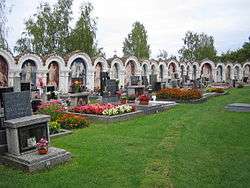
Albrechtice cemetery | |||
| |||
 Albrechtice nad Vltavou | |||
| Coordinates: 49°15′12″N 14°18′10″E / 49.25333°N 14.30278°ECoordinates: 49°15′12″N 14°18′10″E / 49.25333°N 14.30278°E | |||
| Country |
| ||
| Region | South Bohemian | ||
| District | Písek | ||
| Area | |||
| • Total | 61.98 km2 (23.93 sq mi) | ||
| Elevation | 428 m (1,404 ft) | ||
| Population (2011) | |||
| • Total | 835 | ||
| • Density | 13/km2 (35/sq mi) | ||
| Postal code | 398 16 | ||


Albrechtice nad Vltavou is a village and municipality (obec) in Písek District in the South Bohemian Region of the Czech Republic.
The municipality covers an area of 61.98 square kilometres (23.93 sq mi), and has a population of 842 (as at 2005).
Albrechtice nad Vltavou lies approximately 14 kilometres (9 mi) south-east of Písek, 34 km (21 mi) north of České Budějovice, and 93 km (58 mi) south of Prague. The major sight is a Romanesque church of SS Peter and Paul from late 12th century with a churchyard. The walls of the churchyard have a unique arcade decoration with paintings and moralizing verses from 19th century.
The hamlets of Hladná, Chřešťovice, Jehnědno, Údraž and Újezd are administrative parts of Albrechtice nad Vltavou.
References
| Wikimedia Commons has media related to Albrechtice nad Vltavou. |
External links
- Village website (Czech)
This article is issued from Wikipedia - version of the 9/8/2016. The text is available under the Creative Commons Attribution/Share Alike but additional terms may apply for the media files.