Kluky (Písek District)
| Kluky | |||
|---|---|---|---|
| Municipality | |||
 | |||
| |||
 Kluky | |||
| Coordinates: 49°18′57″N 14°14′50″E / 49.31583°N 14.24722°ECoordinates: 49°18′57″N 14°14′50″E / 49.31583°N 14.24722°E | |||
| Country |
| ||
| Region | South Bohemian | ||
| District | Písek | ||
| Area | |||
| • Total | 13.61 km2 (5.25 sq mi) | ||
| Elevation | 460 m (1,510 ft) | ||
| Population (2011) | |||
| • Total | 556 | ||
| • Density | 41/km2 (110/sq mi) | ||
| Postal code | 398 19 | ||
| Website | http://www.municipal.cz/kluky/ | ||

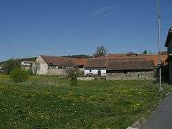
Kluky is a village and municipality (obec) in Písek District in the South Bohemian Region of the Czech Republic.
The municipality covers an area of 13.61 square kilometres (5.25 sq mi), and has a population of 530 (as at 2005).
Kluky lies approximately 9 kilometres (6 mi) east of Písek, 42 km (26 mi) north-west of České Budějovice, and 87 km (54 mi) south of Prague. It is on the road from Záhoří to Albrechtice nad Vltavou. There is an old disused school, a church, two football teams, some pubs and several houses.
References
| Wikimedia Commons has media related to Kluky (Písek District). |
This article is issued from Wikipedia - version of the 4/7/2016. The text is available under the Creative Commons Attribution/Share Alike but additional terms may apply for the media files.