Aoraki/Mount Cook National Park
| Aoraki/Mount Cook National Park | |
|---|---|
|
IUCN category II (national park) | |
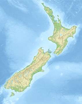 Map of New Zealand | |
| Location | South Island, New Zealand |
| Nearest town | Mount Cook Village |
| Coordinates | 43°44′0″S 170°6′0″E / 43.73333°S 170.10000°ECoordinates: 43°44′0″S 170°6′0″E / 43.73333°S 170.10000°E |
| Area | 707 km2 |
| Established | 1953 |
| Governing body | Department of Conservation |
Aoraki/Mount Cook National Park is in the South Island of New Zealand, near the town of Twizel. Aoraki / Mount Cook, New Zealand's highest mountain and Aoraki/Mount Cook Village lie within the park. The area was gazetted as a national park in October 1953 and consists of reserves that were established as early as 1887 to protect the area's significant vegetation and landscape.[1]
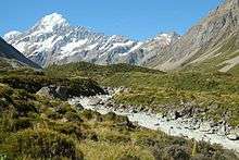
Even though most of the park is alpine terrain, it is easily accessible. The only road access into Aoraki/Mount Cook National Park is via State Highway 80, which starts near Twizel, at 65 kilometres (40 mi) distance the closest town to the park, and leads directly to Mount Cook Village, where the road ends.[2] The village is situated within the park, however, it consists only of a hotel and motels, as well as housing and amenities for the staff of the hotel and motels and other support personnel.[3]
Geography


The park stretches for about 60 kilometres (37 mi) along the southwest-northeast direction of the Southern Alps, covering a little over 700 km2 (270 sq mi) on the southeastern side of the main spine of the Alps. The valleys of the Tasman, Hooker, and Godley glaciers are the only entrances into this alpine territory that lie below 1,000 m (3,300 ft).
Glaciers cover 40% of the park area, notably the Tasman Glacier in the Tasman Valley east of Aoraki / Mount Cook.[1] Eight of the twelve largest glaciers in New Zealand lie within Aoraki/Mount Cook National Park, all of which terminate at proglacial lakes formed in recent decades due to a sustained period of shrinking.[4]
In the area surrounding Aoraki / Mount Cook, the Tasman Glacier, Hooker Glacier, Murchison Glacier, and Mueller Glacier all terminate in lakes, while further north in the park, the Godley Glacier, Classen Glacier, Grey Glacier and Maud Glacier also end in proglacial lakes. Tasman Lake and Hooker Lake are easily accessible via walking tracks and are the only two of these lakes that have official names. At an area of 7 km², Tasman Lake is the largest of the proglacial lakes and hosts boat trips for tourists.[5][6]
Of New Zealand's 20 peaks over 3,000 metres, all except Mount Aspiring / Tititea lie in the park.[7] These include New Zealand's highest mountain, Aoraki / Mount Cook, at 3,724 metres. Other prominent peaks include Mt Tasman, Mt Hicks, Mt Sefton and Mt Elie de Beaumont. The mountains of the Southern Alps in general are young, less than ten million years old, and are still building. Uplift in the region of the national park is at the rate of 5–10 mm per year. It's estimated that approximately 25 km of uplift has occurred, however the rate of uplift has been countered by erosion.[8]
The park borders Westland Tai Poutini National Park along the Main Divide. Together they form part of Te Wahipounamu South Westland World Heritage Site, recognised for its outstanding natural values.[1]
Flora and fauna

More than 400 species of plants make up the vegetation in Aoraki/Mount Cook National Park, which include more than 100 introduced plant species such as the colourful Russell lupin, the wild cherry and wilding pines. Under normal circumstances, forest grows to about 1,300 m, however, most parts of the park are either at higher altitudes above the tree line or in the proglacial valleys such as the Hooker Valley and Tasman Valley, where the rocky soil of the valley floors and moraine walls do not support forest growth. As a result, the only pockets of forest and native bush in the park are along the southern edge of the Hooker Valley and the lower slopes of Sealy Range.[9]
The plant life in the majority of the park consists mostly of alpine plants. Between 1,300 m and 1,900 m and in the valleys, the vegetation is predominately snow tussock grassland, as well as golden speargrass, large mountain daisies/tikumu (Celmisia semicordata, Celmisia coriacea), and Mount Cook lily, (Ranunculus lyallii), the largest buttercup in the world.[1] All of these plants flower in the warmer months from November to February - early in the season in the valley floors, and late at higher altitudes. At the highest rocks of Aoraki / Mount Cook, around 14 species of lichen have been found.[10]
The native vegetation continues to be under threat by introduced plant species ranging from non-native trees through to lupins, broom and non-native grasses. These are mostly contained in the valley floors of the Tasman and Hooker Valley, since they are the most accessible parts of the park.[11]
There are about 35[12] to 40 species of birds in the park and include the kea, the only alpine parrot, and the well-camouflaged pipit. The kea is now only found in the Southern Alps. The tiny rock wren/pïwauwau, a threatened species, is the only permanent resident high on the mountains.[12] It is unrelated to the rock wren of North America. Small insectivores such as the riflemen/tïtitipounamu and the New Zealand fantails/pïwakawaka live in the low forest and scrub, along with small numbers of two larger birds, the wood pigeon and morepork. Introduced species such as finches and sparrows live throughout the bush near Mount Cook Village. The black stilt or kakī, rarest wading bird in the world, lives in the braided riverbed of the Tasman.[1]
The park is home to many invertebrates, including large dragonflies, crickets, grasshoppers, 223 recorded moth species and 7 native butterflies.[13] A black alpine wētā, also known as the Mount Cook flea is found above the snowline. The jewelled gecko lives in the park but is rarely seen.[1] Introduced red deer, chamois and Himalayan tahr can be hunted.[14]

Climate
Temperatures in Mount Cook Village range from −13 °C (9 °F) to 32 °C (90 °F), and typically fall just over 1°C for every 200 metres of altitude.[15]
Rainfall is similarly variable, with the driest months receiving around 300 mm (12 in) precipitation per month, but recorded maxima of 537 mm (21.1 in) in one day and 1,447 mm (57.0 in) in a single month. Snow falls on about 21 days per year.[15]
The weather conditions in the park, in particular at higher altitudes can be unpredictable and change rapidly.[16] Anyone venturing further than the walking tracks is strongly advised to notify their intentions at the Visitor Centre on the day you start. This is part of a formal intentions process that operates in the park and is used to initiate formal search operations.[17]
| Climate data for Mount Cook Village, New Zealand (1981−2010) | |||||||||||||
|---|---|---|---|---|---|---|---|---|---|---|---|---|---|
| Month | Jan | Feb | Mar | Apr | May | Jun | Jul | Aug | Sep | Oct | Nov | Dec | Year |
| Average high °C (°F) | 20.5 (68.9) |
20.7 (69.3) |
17.9 (64.2) |
14.5 (58.1) |
11.0 (51.8) |
7.6 (45.7) |
6.5 (43.7) |
8.6 (47.5) |
11.9 (53.4) |
14.2 (57.6) |
16.5 (61.7) |
18.2 (64.8) |
14.0 (57.2) |
| Daily mean °C (°F) | 14.7 (58.5) |
14.8 (58.6) |
12.3 (54.1) |
9.2 (48.6) |
6.2 (43.2) |
3.3 (37.9) |
2.2 (36) |
3.9 (39) |
6.7 (44.1) |
8.9 (48) |
11.0 (51.8) |
12.8 (55) |
8.8 (47.8) |
| Average low °C (°F) | 9.0 (48.2) |
8.8 (47.8) |
6.8 (44.2) |
4.0 (39.2) |
1.5 (34.7) |
−1.0 (30.2) |
−2.2 (28) |
−0.8 (30.6) |
1.5 (34.7) |
3.6 (38.5) |
5.4 (41.7) |
7.3 (45.1) |
3.7 (38.7) |
| Average precipitation mm (inches) | 457.5 (18.012) |
278.4 (10.961) |
417.9 (16.453) |
363.0 (14.291) |
357.1 (14.059) |
314.5 (12.382) |
305.2 (12.016) |
313.4 (12.339) |
297.4 (11.709) |
478.9 (18.854) |
414.2 (16.307) |
487.2 (19.181) |
4,484.7 (176.563) |
| Average precipitation days (≥ 1.0 mm) | 12.4 | 10.9 | 13.4 | 12.4 | 13.1 | 13.8 | 13.5 | 13.9 | 13.7 | 16.7 | 13.9 | 15.7 | 163.5 |
| Average relative humidity (%) | 75.1 | 78.6 | 79.5 | 79.3 | 81.7 | 83.2 | 80.7 | 80.4 | 72.4 | 72.5 | 73.8 | 75.7 | 77.7 |
| Mean monthly sunshine hours | 184.8 | 167.2 | 151.1 | 125.3 | 92.1 | 66.1 | 74.5 | 113.0 | 130.3 | 149.4 | 158.5 | 168.7 | 1,580.9 |
| Source: NIWA Science climate data[18] | |||||||||||||
Recreation
The park is popular for mountaineering, hunting, tramping/hiking, skiing and ski touring. The Department of Conservation administers activities in the park, including the White Horse Hill camping ground.[19]
Mount Cook Village is the start of several walks ranging from easy walking tracks such as the popular Hooker Valley Track to tramping tracks like the steep track to the Sealy Tarns. Some of these tracks also offer guided walking tours, and the nearby Tasman Lake hosts boat trips for tourists.[20] The park contains close to twenty huts, mostly in alpine terrain. The huts range from basic shelters to serviced huts, with the most accessible hut being Mueller Hut, which can be reached from Mount Cook Village within 4 hours.[17]
A visitor centre in the village features interpretation exhibits about the area's natural environment and history as well as an artwork collection.[21]
Mountaineering

The spectacular peaks of the Aoraki / Mount Cook region have attracted climbers from all over the world for the last 100 years. The dramatic nature of these mountains provides a rare challenge. The combination of heavy glaciation, tremendous vertical scale and unpredictable weather means that they are not readily won. To climb successfully here requires skill, fitness, patience, and a great respect for the mountains. Mountaineering on the Aoraki / Mount Cook massif is a hazardous activity.[22]
Other mountaineering routes include crossing the Aroarokaehe Range via the Copland Pass, the Mount Cook Range via the Ball Pass, and routes crossing the Tasman Saddle further north. All of these routes still require significant alpine mountaineering experience.
On the opposite side of the Hooker Valley, Mt Ollivier was Sir Edmund Hillary's first major climb, in 1939, and since the establishment of a tramping track to Mueller Hut, not far below the summit, is now one of the easiest accessible mountains in the park.
Another mountain popular for mountaineers of intermediate skills is Mt Sebastopol, the closest mountain to Mount Cook Village. At 1,468 m height, it is only 750 m above Mount Cook Village, with the lower half of the ascent following the Red Tarns tramping track.[23] Mt Sebastopol offers one of few view points taking in both the Hooker Valley and the Tasman Valley.
Area history

At the end of the most recent ice age, around 13,000 years ago,[24] the Mueller Glacier, Hooker Glacier, and Tasman Glacier were all tributaries to a much larger glacier covering all of Hooker Valley and Tasman Valley in hundreds of metres of ice and reaching as far as the extent of today's Lake Pukaki,[25] up to 40 km (25 mi) south of Aoraki / Mount Cook National Park.
As the glacier retreated, it filled the hollowed out valleys with rocks and gravel, leaving behind the flat-bottomed valleys seen today.
- 1642 - Aoraki possibly sighted by Abel Tasman and crew members[26]
- 1770 - Captain Cook named the Southern Alps
- 1851 - Captain Stokes of the survey ship HMS Acheron gave the name Mount Cook to Aoraki
- 1884 - First Hermitage built under the direction of Frank Huddleson
- 1894 - First ascent of Aoraki / Mount Cook, on Christmas Day, by Jack Clarke, Tom Fyfe and George Graham
- 1910 - Freda du Faur became the first woman to climb Aoraki / Mount Cook
- 1911 - The vital swing bridge is built in the Hooker Valley
- 1913 - First ascents of the footstool and Mt Sefton made by Freda du Faur's climbing party
- 1913 - Hermitage first ravaged by floods in January, then destroyed beyond repair by floods two months later
- 1914 - First fatal accident, when three men caught in avalanche on Linda Glacier
- 1914 - Second Hermitage opened, on different site
- 1957 - Second Hermitage razed to the ground
- 1958 - Third Hermitage built (later extended to become the current Hermitage hotel)
- 1960 - First school opens, Aoraki Mount Cook School[3]
- 1961 - Passenger flights begin by Mount Cook Airline, now part of Air New Zealand Link
- 1975 - State Highway 80 is sealed, improving access to the national park[3]
- 1982 - Mark Inglis trapped in snow cave
- 1991 - Avalanche of 10 million cubic metres of snow and rock causes 10 metres to be lost off the top of Aoraki / Mount Cook[27][28] Two decades of erosion of the ice cap exposed after this collapse reduced the height by another 30 m to 3,724 m, as revealed by new GPS data from a University of Otago climbing expedition in November 2013.[29][30]
- 1998 - The Ngāi Tahu Claims Settlement Act officially recognises the original name, renaming the mountain Aoraki / Mount Cook[31]
Transport
Rodolph Wigley's Mount Cook Motor Co was formed in 1906 to provide services to the area from the railhead at Fairlie.[32] A small airfield, Mount Cook Aerodrome, 5 km (3.1 mi) southeast of Mount Cook Village has been served by the Wigley family's New Zealand Aero Transport Company and successor Mount Cook Airline sporadically since 1921.
Road access into the park is via State Highway 80, along the western shore of Lake Pukaki. The road ends at Mount Cook Village, with a connecting road leading to the White Horse Hill camping ground. Another small road leads to a car park near Tasman Lake, the start of a short walking track and the Ball Hut Route.
Aoraki/Mount Cook National Park is the starting point of the Alps to Ocean Cycle Trail to Oamaru. The 300 kilometre cycle trail has been constructed from 2010 onwards by the New Zealand Cycle Trail project. As of 2016 the cycle trail still includes 15 kilometres along public roads.[33]
See also
- Aoraki / Mount Cook
- List of mountains of New Zealand by height
- Southern Alps
- National parks of New Zealand
- Forest parks of New Zealand
- Protected areas of New Zealand
References
- 1 2 3 4 5 6 "Aoraki/Mount Cook National Park". Department of Conservation. Retrieved 2016-09-06.
- ↑ "Aoraki/Mount Cook, Canterbury - NZ Topo Map". NZ Topo Map. Land Information New Zealand. Retrieved 2016-09-06.
- 1 2 3 "Aoraki/Mount Cook Village: Long-term Community Plan" (PDF). Department of Conservation. Retrieved 2016-09-06.
- ↑ "New Zealand glaciers shrinking". NIWA. Retrieved 2016-09-06.
- ↑ "Tasman Lake, Canterbury - NZ Topo Map". NZ Topo Map. Land Information New Zealand. Retrieved 2016-09-06.
- ↑ "Hooker Lake, Canterbury - NZ Topo Map". NZ Topo Map. Land Information New Zealand. Retrieved 2016-09-06.
- ↑ "Aoraki/Mount Cook National Park: Places to go in Canterbury". Department of Conservation. Retrieved 2016-09-06.
- ↑ "Aoraki/Mount Cook Education Resource" (PDF). Department of Conservation. 2010. p. 7. Retrieved 2016-09-07.
- ↑ "Nature and conservation: Aoraki/Mount Cook National Park". Department of Conservation. Retrieved 2016-09-08.
- ↑ "Aoraki/Mount Cook Education Resource" (PDF). Department of Conservation. 2010. p. 17. Retrieved 2016-09-07.
- ↑ "Aoraki/Mount Cook National Park Management Plan - 4. Park Policies" (PDF). Department of Conservation. Retrieved 2016-09-08.
- 1 2 "Aoraki/Mount Cook Education Resource" (PDF). Department of Conservation. 2010. p. 18. Retrieved 2016-09-07.
- ↑ "Aoraki/Mount Cook Education Resource" (PDF). Department of Conservation. 2010. p. 19. Retrieved 2016-09-07.
- ↑ "Aoraki/Mount Cook - hunting". Department of Conservation. Retrieved 2016-09-07.
- 1 2 "Aoraki/Mount Cook Education Resource" (PDF). Department of Conservation. 2010. p. 8. Retrieved 2016-09-07.
- ↑ "Deadly Mt Cook lures Australian climbers". ABC News. 15 Dec 2008. Retrieved 2016-09-07.
- 1 2 "Mueller Hut Route: Walking and tramping in Aoraki / Mount Cook National Park". Department of Conservation. Retrieved 2016-09-07.
- ↑ "Climate Data and Activities". NIWA Science. Retrieved October 15, 2013.
- ↑ "White Horse Hill Campground". Department of Conservation. Retrieved 2016-09-07.
- ↑ Michael Fox (14 July 2013). "Government sees dollars in national parks". Stuff.co.nz. Retrieved 2016-09-06.
- ↑ "Aoraki/Mount Cook National Park visitor centre". Department of Conservation. Retrieved 2016-09-07.
- ↑ Aoraki/Mount Cook Expedition | Summer 2014/15 alpineguides.co.nz
- ↑ "Sebastopol, Canterbury - NZ Topo Map". NZ Topo Map. Land Information New Zealand. Retrieved 2016-09-07.
- ↑ "NZ study pinpoints the final cold snap of the last ice age". GNS Science. 27 Sep 2010. Retrieved 2016-09-07.
- ↑ "Glaciation". Te Ara: The Encyclopedia of New Zealand. Retrieved 2016-09-07.
- ↑ "2. – European discovery of New Zealand – Te Ara Encyclopedia of New Zealand". Te Ara: The Encyclopedia of New Zealand. 11 May 2016. Retrieved 2016-09-07.
- ↑ . The landslide carried with it another 40 million cubic metres of rock and ice.The impact caused an earth quake of 3.9 on the Richter scale. <P207 In search Of Ancient NZ.Campball and Hutching.GNS science/Penguin.2011.> Michael J. Crozier. "Mt Cook landslide". Te Ara: The Encyclopedia of New Zealand. Retrieved 3 May 2007.
- ↑ T. J. Chinn; M. J. McSaveney (1992). "Mount Aoraki (Mount Cook) rock avalanche". Tai Awatea - Knowledge Net (More of Te Papa online). Retrieved 3 May 2007.
- ↑ "Height of NZ's tallest peak Aoraki/Mt Cook slashed by 30m". The New Zealand Herald. 16 January 2014. Retrieved 2016-09-06.
- ↑ Otago-led study revises height of Aoraki/Mt Cook
- ↑ Graham, Doug (13 October 1998). "Ngai Tahu Settlement Section 3: Aoraki/Mount Cook". New Zealand Government. Retrieved 10 June 2012.
- ↑ John McCrystal On the Buses in New Zealand: from charabancs to the coaches of today, Grantham House, Wellington, 2007
- ↑ "Alps 2 Ocean Cycle Trail FAQ". A2O Charitable Trust. Retrieved 2016-09-13.
External links
| Wikimedia Commons has media related to Aoraki/Mount Cook National Park. |
| Wikivoyage has a travel guide for Aoraki Mount Cook National Park. |
- Aoraki/Mount Cook National Park
- Aoraki/Mount Cook National Park Education Resource 2010
- Mt Cook: Does reaching summit outweigh risks?