Arambaré
| Arambaré | ||
|---|---|---|
| Municipality | ||
|
Beach in Arambaré | ||
| ||
| Nickname(s): Capital das Figueiras | ||
 | ||
| Coordinates: 30°54′54″S 51°29′52″W / 30.91500°S 51.49778°W | ||
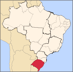
| Country | Brazil | |
| State | Rio Grande do Sul | |
| Mesoregion | Metropolitana de Porto Alegre [1] | |
| Microregion | Camaquã [1] | |
| Founded | March 20, 1992 | |
| Government | ||
| • Mayor | Joselena Maria Becker Scherer (PDT) | |
| Area | ||
| • Total | 519.124 km2 (200.435 sq mi) | |
| Elevation | 5 m (16 ft) | |
| Population est. IBGE/2008[2] | ||
| • Total | 3,931 | |
| • Density | 7.6/km2 (20/sq mi) | |
| Time zone | -3 | |
| HDI | 0.743[3] | |
| GDP | R$ 39,253,000[4] | |
| GDP per capita | R$8,770.00 | |

Arambaré is a municipality in the state Rio Grande do Sul, Brazil. It is bordered by Tapes on the north, Camaquã on the west and south, and Lagoa dos Patos on the east. It is at km 396 of the BR-116, 33 km from Camaquã. It is 156 km from Porto Alegre.
Arambaré, in Guarani, means "priest who shines light." Its origin was the Tape people, who populated the Lagoa dos Patos coast. Later the place was known as Barra do Velhaco and Paraguaçu. Dunas da Lua de Natal and Prainha are two of the baths found in the city.
In summer, tourism is the most important industry. The rural area is known for its rice and livestock.
The city is well known for its Carnaval, when thousands of tourists visit.
References
- 1 2 "Divisão Territorial do Brasil". Divisão Territorial do Brasil e Limites Territoriais. Instituto Brasileiro de Geografia e Estatística (IBGE). 1 July 2008. Retrieved 11 October 2008.
- ↑ "Estimativas da população para 1º de julho de 2008" (PDF). Instituto Brasileiro de Geografia e Estatística (IBGE). 29 August 2008. Archived (PDF) from the original on 8 September 2008. Retrieved 5 September 2008.
- ↑ "Ranking decrescente do IDH-M dos municípios do Brasil". Atlas do Desenvolvimento Humano. Programa das Nações Unidas para o Desenvolvimento (PNUD). 2000. Archived from the original on 3 October 2009. Retrieved 11 October 2008.
- ↑ "Produto Interno Bruto dos Municípios 2002-2005" (PDF). Instituto Brasileiro de Geografia e Estatística (IBGE). 19 December 2007. Archived from the original (PDF) on 2 October 2008. Retrieved 11 October 2008.
External links
Coordinates: 30°55′S 51°29′W / 30.917°S 51.483°W
This article is issued from Wikipedia - version of the 10/17/2016. The text is available under the Creative Commons Attribution/Share Alike but additional terms may apply for the media files.