Ashland, Chemung County, New York
| Ashland, New York | |
|---|---|
| Town | |
|
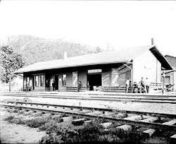
Wellsburg, the main village in Ashland | |
 Ashland Location within the state of New York | |
| Coordinates: 42°1′21″N 76°44′22″W / 42.02250°N 76.73944°WCoordinates: 42°1′21″N 76°44′22″W / 42.02250°N 76.73944°W | |
| Country | United States |
| State | New York |
| County | Chemung |
| Government | |
| • Type | Town Council |
| • Town Supervisor | Vern K. Robinson |
| • Town Council |
Members' List
|
| Area | |
| • Total | 14.6 sq mi (37.7 km2) |
| • Land | 14.2 sq mi (36.7 km2) |
| • Water | 0.3 sq mi (0.9 km2) |
| Elevation | 827 ft (252 m) |
| Population (2010) | |
| • Total | 1,695 |
| • Density | 119/sq mi (46.1/km2) |
| Time zone | Eastern (EST) (UTC-5) |
| • Summer (DST) | EDT (UTC-4) |
| ZIP code | 14894 (Wellsburg) |
| FIPS code | 36-02781 |
| GNIS feature ID | 0978691 |
| Website |
townofashland |
Ashland is a town in Chemung County, New York, United States. The population was 1,695 at the 2010 census.[1] The town is named after the home of Henry Clay.
Ashland is on the south border of the county, south of Elmira. It is part of the Elmira Metropolitan Statistical Area.
History
In 1779, the Battle of Newtown, a consequence of the Sullivan Expedition, was fought in the north part of the town.
The first settlers arrived around 1788. The town of Ashland was formed in 1867 from parts of the towns of Chemung, Elmira and Southport. The founders of the town wanted to name it after a prominent citizen, R.C. Lockwood, but he suggested the name "Ashland". Ashland was the last town created in Chemung County.
Growing and shipping tobacco was a popular endeavor after 1858.
Geography
According to the United States Census Bureau, the town has a total area of 14.6 square miles (37.7 km2), of which 14.2 square miles (36.7 km2) is land and 0.35 square miles (0.9 km2), or 2.44%, is water.[1]
The Chemung River, a tributary of the Susquehanna River, flows through the town. The south town line of Ashland is the border of Pennsylvania.
New York State Route 14, New York State Route 17, and New York State Route 427 are highways in the town. New York State Route 367 is a short state highway near Wellsburg.
Demographics
| Historical population | |||
|---|---|---|---|
| Census | Pop. | %± | |
| 1870 | 1,558 | — | |
| 1880 | 1,149 | −26.3% | |
| 1890 | 983 | −14.4% | |
| 1900 | 954 | −3.0% | |
| 1910 | 769 | −19.4% | |
| 1920 | 834 | 8.5% | |
| 1930 | 948 | 13.7% | |
| 1940 | 951 | 0.3% | |
| 1950 | 1,188 | 24.9% | |
| 1960 | 1,273 | 7.2% | |
| 1970 | 1,726 | 35.6% | |
| 1980 | 1,967 | 14.0% | |
| 1990 | 1,966 | −0.1% | |
| 2000 | 1,951 | −0.8% | |
| 2010 | 1,695 | −13.1% | |
| Est. 2014 | 1,653 | [2] | −2.5% |
As of the census[4] of 2000, there were 1,951 people, 785 households, and 518 families residing in the town. The population density was 138.0 people per square mile (53.3/km²). There were 839 housing units at an average density of 59.3 per square mile (22.9/km²). The racial makeup of the town was 98.51% White, 0.36% African American, 0.21% Native American, 0.10% Asian, 0.10% from other races, and 0.72% from two or more races. Hispanic or Latino of any race were 0.62% of the population.
There were 785 households out of which 28.2% had children under the age of 18 living with them, 51.7% were married couples living together, 8.5% had a female householder with no husband present, and 34.0% were non-families. 26.5% of all households were made up of individuals and 12.9% had someone living alone who was 65 years of age or older. The average household size was 2.48 and the average family size was 3.01.
In the town the population was spread out with 24.9% under the age of 18, 6.9% from 18 to 24, 27.0% from 25 to 44, 24.7% from 45 to 64, and 16.6% who were 65 years of age or older. The median age was 40 years. For every 100 females there were 103.0 males. For every 100 females age 18 and over, there were 100.0 males.
The median income for a household in the town was $33,629, and the median income for a family was $40,882. Males had a median income of $32,012 versus $21,553 for females. The per capita income for the town was $17,749. About 8.7% of families and 11.2% of the population were below the poverty line, including 14.3% of those under age 18 and 4.7% of those age 65 or over.
Communities and locations in Ashland
- Baldwin Island – An island in the Chemung River north of Wellsburg.
- Big Island – An island in the Chemung River northwest of Baldwin Island.
- Comfort Hill – A prominent hill on the west side of the town.
- Lowman – A hamlet, partly in the town, north of the Chemung River on NY-17 at the intersection of County Road 8.
- Newtown Battlefield Reservation – The site of the Battle of Newtown is in the north part of the town by the Chemung River.
- Wellsburg – The village of Wellsburg is near the Pennsylvania border. It is named after early settler, Abner Wells.
References
- 1 2 "Geographic Identifiers: 2010 Demographic Profile Data (G001): Ashland town, Chemung County, New York". U.S. Census Bureau, American Factfinder. Retrieved October 31, 2014.
- ↑ "Annual Estimates of the Resident Population for Incorporated Places: April 1, 2010 to July 1, 2014". Retrieved June 4, 2015.
- ↑ "Census of Population and Housing". Census.gov. Archived from the original on May 11, 2015. Retrieved June 4, 2015.
- ↑ "American FactFinder". United States Census Bureau. Archived from the original on 2013-09-11. Retrieved 2008-01-31.
External links
- Town of Ashland official website
- Tri-Counties Genealogy & History: Town of Ashland & Village of Wellsburg, Chemung County NY
Municipalities and communities of Chemung County, New York, United States | ||
|---|---|---|
| City | 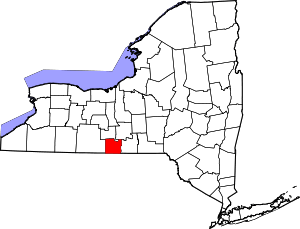 | |
| Towns | ||
| Villages | ||
| CDPs | ||
| Hamlets | ||