Assineau River
| Assineau River | |
|---|---|
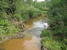 The Assineau River after heavy rainfall | |
| Country | Canada |
| Basin | |
| Main source |
Sawridge Hill, Grizzly Ridge Wildland Provincial Park 819 m (2,687 ft) 55°13′24″N 115°13′13″W / 55.22333°N 115.22028°W |
| River mouth |
Lesser Slave Lake 577 m (1,893 ft) 55°23′27″N 115°11′54″W / 55.39083°N 115.19833°WCoordinates: 55°23′27″N 115°11′54″W / 55.39083°N 115.19833°W |
The Assineau River is a short river forming in central Alberta. The Assineau flows into Lesser Slave Lake, which flows out through the Lesser Slave River, a major tributary of the Athabasca River. The name for the river was in use by 1904. It is suggested that Assineau is a version of the Cree word for nobody.[1]
The river forms in Grizzly Ridge Wildland Provincial Park and heads north towards Lesser Slave Lake. The river is bridged by Alberta Highway 2 and flows past the hamlet of Assineau, Alberta.[2]

The Assineau near Lesser Slave Lake
See also
References
This article is issued from Wikipedia - version of the 4/7/2016. The text is available under the Creative Commons Attribution/Share Alike but additional terms may apply for the media files.