Awdalland
| Awdalland أرض أودال |
||||
|---|---|---|---|---|
|
||||
| Anthem: Soomaaliyeey toosoo | ||||
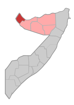 Location of Awdal in Somalia.
|
||||
| Capital | Borama 9°55′N 43°10′E / 9.917°N 43.167°E | |||
| Official languages | ||||
| Government | ||||
| • | President | Mahdi Isaaq | ||
| Autonomy Federal Republic of Somalia | ||||
| • | Proclaimed | 2009 | ||
| • | Recognition | unrecognized | ||
| Area | ||||
| • | Total | 6,122 km2 2,364 sq mi |
||
| Currency | Somali shilling (SOS) | |||
| Time zone | EAT (UTC+3) | |||
| • | Summer (DST) | not observed (UTC+3) | ||
| Calling code | +252 (Somalia) | |||
| Internet TLD | .so (Somalia) | |||
| Rankings may not be available because of Awdalland's unrecognized de facto state. | ||||


Awdalland (Somali: Awdalland Arabic: أرض أودال) is a region in northwestern Somalia. Centered on Borama, the capital of the Awdal province, its leaders declared the territory an autonomous state since 1995 and later join to Somalia federal central government, but Somaliland have some kind of control of the territory.[1]
History
Awdalland (also spelled "Adal[land]" or "Adel[land]") takes its name from the Adal Sultanate, a medieval empire which rose to power during the 16th century. The area along the Ethiopian border is abundant with ruined cities, which were described by the British explorer Richard F. Burton.[2]
In 1995, after the collapse of the Somalian central government, a local separatist movement known as the Awdal Republic or Awdalland Republic briefly sought independence.[3]
In 2009, the formation of a new autonomous region within a federal Somalia was officially declared. Referred to as Awdalland or the Adal State, the local administration does not recognize the secessionist Somaliland government's claim to sovereignty or to its territory.[4][5] In 2011 here is declared Zeila & Lughaya State with capital town Zeila that again does not recognize the power of the Somaliland government and claiming to be a federal state of Somalia. Saylac (Zeila) and Lughaya State was formed in 2011 and on 7 February 2012 officially go out of Somaliland, claiming to be a federal state of Somalia. Zeila State is proclaimed first. It later united with Lugayhe to form the state of Sayla and Lugayhe. Each individual state and the combined state has its own flag. However, the government of Somaliland soon regained some kind of control of the territory. The territory has a total area of 8,566 km2 (3,307 sq mi). Its main city is Zeila, which is situated on the coast. Lughaya, Asha Addo, Harirad, Jidhi and Lawyacado are the other principal cities in the region.
Demographics
The Awdal region of Awdalland is primarily inhabited by Somalis from the Gadabuursi clans.[6][7]
References
- ↑ Bselvy. Countries that are not really Countries. AnVi OpenSource Knowledge Trust. p. 12.
- ↑ Richard Burton, First Footsteps in East Africa, 1856; edited with an introduction and additional chapters by Gordon Waterfield (New York: Praeger, 1966), p. 132. For a more recent description, see A. T. Curle, "The Ruined cities of Somaliland", Antiquity, 11 (1937), pp. 315-327
- ↑ "Awdal "Republic": Declaration of Independence, [Somalia]". University of Pennsylvania - African Studies Center. Archived from the original on 14 February 2007. Retrieved 2007-01-29.
- ↑ "The Declaration of Adal State". Lughaya. 8 September 2009. Archived from the original on 14 July 2014. Retrieved 24 June 2014.
- ↑ "Awdalland Deserves Recognition – New Song (Daawo)". SSC Times. 7 August 2010. Retrieved 6 December 2013.
- ↑ Battera, Federico (2005). "Chapter 9: The Collapse of the State and the Resurgence of Customary Law in Northern Somalia". Shattering Tradition: Custom, Law and the Individual in the Muslim Mediterranean. Walter Dostal, Wolfgang Kraus (ed.). London: I.B. Taurus. p. 296. ISBN 1-85043-634-7. Retrieved 2010-03-18.
Awdal is mainly inhabited by the Gadabuursi confederation of clans. The Gadaabursi are concentrated in Awdal....
- ↑ Northeast African Studies, Volume 9. Michigan State University. 1987. p. 35.
…the new 'Awdal' region almost entirely inhabited by Samaroon.
External links
- SSC TIMES - Real Voice of Sool Sanaag Cayn - Awdalland
- The Emergence of Awdalland a Vital Reality Check for Secessionist One-Clan-Somaliland
- Somaliland is not ours any more. Awdalland is our own. A reply to Mudane Mo
- (Somali) Heestii Calanka Awdalland
- Doorashadii Madaxweynaha
Somalia articles | |||||||||
|---|---|---|---|---|---|---|---|---|---|
| History |
|  | |||||||
| Geography |
| ||||||||
| Politics |
| ||||||||
| Economy | |||||||||
| Society |
| ||||||||
| |||||||||