Béon, Ain
| Béon | |
|---|---|
|
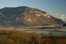
The Grand Colombier and the Lavours wetlands | |
 Béon | |
|
Location within Auvergne-Rhône-Alpes region  Béon | |
| Coordinates: 45°50′00″N 5°45′00″E / 45.8333°N 5.75°ECoordinates: 45°50′00″N 5°45′00″E / 45.8333°N 5.75°E | |
| Country | France |
| Region | Auvergne-Rhône-Alpes |
| Department | Ain |
| Arrondissement | Belley |
| Canton | Champagne-en-Valromey |
| Intercommunality | Colombier |
| Government | |
| • Mayor (2008–2014) | Paul Bois |
| Area1 | 10.30 km2 (3.98 sq mi) |
| Population (2008)2 | 354 |
| • Density | 34/km2 (89/sq mi) |
| Time zone | CET (UTC+1) |
| • Summer (DST) | CEST (UTC+2) |
| INSEE/Postal code | 01039 / 01350 |
| Elevation |
228–1,412 m (748–4,633 ft) (avg. 235 m or 771 ft) |
|
1 French Land Register data, which excludes lakes, ponds, glaciers > 1 km² (0.386 sq mi or 247 acres) and river estuaries. 2 Population without double counting: residents of multiple communes (e.g., students and military personnel) only counted once. | |
Béon is a commune in the Ain department in eastern France.
Population
| Historical population | ||
|---|---|---|
| Year | Pop. | ±% |
| 1793 | 492 | — |
| 1800 | 476 | −3.3% |
| 1806 | 422 | −11.3% |
| 1821 | 488 | +15.6% |
| 1831 | 527 | +8.0% |
| 1836 | 521 | −1.1% |
| 1841 | 513 | −1.5% |
| 1846 | 546 | +6.4% |
| 1851 | 528 | −3.3% |
| 1856 | 543 | +2.8% |
| 1861 | 507 | −6.6% |
| 1866 | 466 | −8.1% |
| 1872 | 461 | −1.1% |
| 1876 | 452 | −2.0% |
| 1881 | 414 | −8.4% |
| 1886 | 405 | −2.2% |
| 1891 | 394 | −2.7% |
| 1896 | 446 | +13.2% |
| 1901 | 417 | −6.5% |
| 1906 | 376 | −9.8% |
| 1911 | 356 | −5.3% |
| 1921 | 314 | −11.8% |
| 1926 | 319 | +1.6% |
| 1931 | 313 | −1.9% |
| 1936 | 315 | +0.6% |
| 1946 | 282 | −10.5% |
| 1954 | 320 | +13.5% |
| 1962 | 313 | −2.2% |
| 1968 | 298 | −4.8% |
| 1975 | 345 | +15.8% |
| 1982 | 346 | +0.3% |
| 1990 | 348 | +0.6% |
| 1999 | 364 | +4.6% |
| 2008 | 354 | −2.7% |
See also
References
| Wikimedia Commons has media related to Béon, Ain. |
This article is issued from Wikipedia - version of the 10/27/2016. The text is available under the Creative Commons Attribution/Share Alike but additional terms may apply for the media files.