Baghaita
| Baghaita बघाईता | |
|---|---|
| Village | |
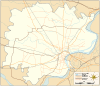 Baghaita  Baghaita  Baghaita Village location on Varanasi district map | |
| Coordinates: 25°25′31″N 82°53′35″E / 25.425203°N 82.892997°ECoordinates: 25°25′31″N 82°53′35″E / 25.425203°N 82.892997°E | |
| Country |
|
| State | Uttar Pradesh |
| District | Varanasi district |
| Tehsil | Pindra |
| Elevation | 83.131 m (272.740 ft) |
| Population (2011) | |
| • Total | 41 |
| Languages | |
| • Official | Hindi |
| Time zone | IST (UTC+5:30) |
| Postal code | 221202 |
| Telephone code | +91-542 |
| Vehicle registration | UP65 XXXX |
| Village code | 208731 |
| Lok Sabha constituency | Varanasi |
| Vidhan Sabha constituency | Pindra |
Baghaita (Hindi: बघाईता) is a village in Pindra Tehsil of Varanasi district in the Indian state of Uttar Pradesh. The village falls under Nihalapur gram panchayat. The village is about 20 kilometers North-West of Varanasi city, 266 kilometers South-East of state capital Lucknow and 804 kilometers South-East of the national capital Delhi.[1][2][3][4][5][6][7]
Demography
Baghaita has 8 families with the total population of 41. Sex ratio of the village is 1,158 and child sex ratio is 5,000. Uttar Pradesh state average for both ratios is 912 and 902 respectively [note].[5]
| Details | Male | Female | Total | Comments |
|---|---|---|---|---|
| Number of houses | - | - | 8 | (census 2011) [5] |
| Adult | 18 | 17 | 35 | |
| Children (0–6 years) | 1 | 5 | 6 | |
| Total population | 19 | 22 | 41 | |
| Literacy | 94.44% | 52.94% | 74.29% | |
Transportation
Baghaita is connected by air (Lal Bahadur Shastri Airport), train (Babatpur railway station) and by road. The nearest operational airports are Varanasi airport (5.5 kilometers South) and Allahabad Airports (143 kilometers West).[8][9]
See also
Notes
- ^ All demographic data is based on 2011 Census of India.
References
- ↑ "Village coordinates". latlong.net. Retrieved Sep 2015. Check date values in:
|access-date=(help) - ↑ "Elevation". daftlogic.com. Retrieved Sep 2015. Check date values in:
|access-date=(help) - ↑ "Delimitation of Parliamentary and Assembly Constituencies Order, 2008" (PDF). Election Commission of India official website. Retrieved Sep 2015. Check date values in:
|access-date=(help) - ↑ "Village code & Tehsil". Local Government directory. Retrieved Sep 2015. Check date values in:
|access-date=(help) - 1 2 3 "Demography". 2011 census. Retrieved Sep 2015. Check date values in:
|access-date=(help) - ↑ "Village code". villageinfo.in. Retrieved Sep 2015. Check date values in:
|access-date=(help) - ↑ "About village". Maps of India. Retrieved Sep 2015. Check date values in:
|access-date=(help) - ↑ "Rail information". indiarailinfo.com. Retrieved Sep 2015. Check date values in:
|access-date=(help) - ↑ "Location". Google Maps. Retrieved Sep 2015. Check date values in:
|access-date=(help)
Villages in Varanasi district | ||
|---|---|---|
| Pindra Tehsil |
| |
| Varanasi Tehsil | ||
India : Uttar Pradesh : Varanasi | ||
 |
Sultanpur | Amaut | Mau | |
| Allahabad | |
Patna | ||
| ||||
| | ||||
| Mirzapur district | Lohta | Varanasi |