Adhkatiya Kala Khas
| Adhkatiya Kala Khas अधकटिया कला खास | |
|---|---|
| Village | |
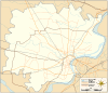 Adhkatiya Kala Khas  Adhkatiya Kala Khas  Adhkatiya Kala Khas Village location on Varanasi district map | |
| Coordinates: 25°25′06″N 82°43′24″E / 25.418372°N 82.723250°ECoordinates: 25°25′06″N 82°43′24″E / 25.418372°N 82.723250°E | |
| Country |
|
| State | Uttar Pradesh |
| District | Varanasi district |
| Tehsil | Pindra |
| Elevation | 83 m (272 ft) |
| Population (2011) | |
| • Total | 67 |
| Languages | |
| • Official | Hindi |
| Time zone | IST (UTC+5:30) |
| Postal code | 221206 |
| Telephone code | +91-5450 |
| Vehicle registration | UP65 XXXX |
| Village code | 208529 |
| Lok Sabha constituency | Varanasi |
| Vidhan Sabha constituency | Pindra |
Adhkatiya Kala Khas (Hindi: अधकटिया कला खास) (also known as Adhikariya Kala) is a village in Pindra Tehsil of Varanasi district in the Indian state of Uttar Pradesh. Adhkatiya Kala Khas falls under the Tilvar gram panchayat. The village is about 34 kilometers North-West of Varanasi city, 280 kilometers South-East of state capital Lucknow and 783 kilometers South-East of the national capital Delhi.[1][2][3][4][5]
Demography
Adhkatiya Kala Khas has a total population of 67 people amongst 7 families. Sex ratio of Adhkatiya Kala Khas is 763 and child sex ratio is 400. Uttar Pradesh state average for both ratios is 912 and 902 respectively[note].[3]
| Details | Male | Female | Total | Comments |
|---|---|---|---|---|
| Number of houses | - | - | 7 | (census 2011) [3] |
| Adult | 33 | 27 | 60 | |
| Children (0–6 years) | 5 | 2 | 7 | |
| Total population | 38 | 29 | 67 | |
| Literacy | 87.88% | 62.96% | 76.67% | |
Transportation
Adhkatiya Kala Khas can be accessed by road and does not have a railway station of its own. Closest railway station to this village is Babatpur Railway Station (25 kilometres (16 mi) east). Nearest operational airports are Varanasi airport (24.5 kilometres (15.2 mi) east) and Allahabad Airports (122 kilometres (76 mi) west).[6][7]
See also
Notes
- ^ All demographic data is based on 2011 Census of India.
References
- ↑ "Village coordinates". latlong.net. Retrieved 15 October 2016.
- ↑ "Elevation". daftlogic.com. Retrieved 15 October 2016.
- 1 2 3 "Demography". 2011 census. Retrieved 15 October 2016.
- ↑ "Village code & Tehsil". Local Government directory. Retrieved 15 October 2016.
- ↑ "PIN & STD Code". One Five Nine. Retrieved 15 October 2016.
- ↑ "Rail information". indiarailinfo.com. Retrieved 15 October 2016.
- ↑ "Location". Google Maps. Retrieved 15 October 2016.
Villages in Varanasi district | ||
|---|---|---|
| Pindra Tehsil |
| |
| Varanasi Tehsil | ||
India : Uttar Pradesh : Varanasi | ||
 |
Shahganj | Mau | | |
| Allahabad | |
|||
| ||||
| | ||||
| Bhadohi | Varanasi |