Bahrain, Pakistan
| Bahrain | |
|---|---|
| Valley | |
 Bahrain Valley | |
| Country |
|
| Province | Khyber Pakhtunkhwa |
| District | Swat |
| Elevation | 1,435 m (4,708 ft) |
| Time zone | PST (UTC+5) |
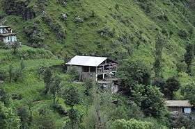
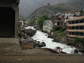
Bahrain (Torwali/Pashto: بحرین; also spelled Behrain) is a popular hill station located in Swat District of Khyber Pakhtunkhwa, Pakistan, 60 km North of Mingora at an elevation of 4700 ft on the right bank of Swat river. It got its name (lit. "two rivers") because of its location at the confluence of the Daral and Swat rivers.
It is famous for its riverside tourist resorts, local handicrafts and offers a superb view of gushing river Daral and its merging with river Swat.
The people of Bahrain are expert in the cottage industry of wood carving, that's why wood work can be seen everywhere in the region. Similarly, it serve as perfect base camp of a charming trail that leads to Daral & Saidgai lakes.
Climate
With a mild and generally warm and temperate climate, Bahrain features a humid subtropical climate (Cfa) under the Köppen climate classification. The average temperature in Bahrain is 16.6 °C, while the annual precipitation averages 866 mm. Even in the driest months, there is a lot of precipitation. November is the driest month with 21 mm of precipitation, while March, the wettest month, has an average precipitation of 120 mm.
July is the hottest month of the year with an average temperature of 27.0 °C. The coldest month January has an average temperature of 4.8 °C.
| Climate data for Bahrain | |||||||||||||
|---|---|---|---|---|---|---|---|---|---|---|---|---|---|
| Month | Jan | Feb | Mar | Apr | May | Jun | Jul | Aug | Sep | Oct | Nov | Dec | Year |
| Average high °C (°F) | 9.1 (48.4) |
11.1 (52) |
16.3 (61.3) |
21.8 (71.2) |
27.2 (81) |
33.3 (91.9) |
33.5 (92.3) |
32.2 (90) |
29.6 (85.3) |
24.7 (76.5) |
18.7 (65.7) |
11.7 (53.1) |
22.43 (72.39) |
| Daily mean °C (°F) | 4.8 (40.6) |
6.5 (43.7) |
11.1 (52) |
16.1 (61) |
20.8 (69.4) |
26.2 (79.2) |
27.0 (80.6) |
26.0 (78.8) |
23.1 (73.6) |
17.9 (64.2) |
12.5 (54.5) |
7.0 (44.6) |
16.58 (61.85) |
| Average low °C (°F) | 0.6 (33.1) |
2.0 (35.6) |
5.9 (42.6) |
10.4 (50.7) |
14.5 (58.1) |
19.2 (66.6) |
20.5 (68.9) |
19.9 (67.8) |
16.6 (61.9) |
11.2 (52.2) |
6.4 (43.5) |
2.4 (36.3) |
10.8 (51.44) |
| Source: Climate-Data.org[1] | |||||||||||||
Accommodation
Bahrain hosts large number of lodging hotels and restaurants, where one can stay for night and relish the cool breeze of Suvastu river. Similarly, different food huts are working up to late night and serving the people through delicious food dishes.
See also
References
- ↑ "Climate: Bahrain - Climate-Data.org". Retrieved 15 September 2016.
External links
Coordinates: 35°12′27″N 72°32′44″E / 35.2075°N 72.5456°E