Baie-Trinité, Quebec
| Baie-Trinité | |
|---|---|
| Village municipality | |
 | |
 Baie-Trinité Location in Côte-Nord region of Quebec. | |
| Coordinates: 49°25′N 67°18′W / 49.417°N 67.300°WCoordinates: 49°25′N 67°18′W / 49.417°N 67.300°W[1] | |
| Country |
|
| Province |
|
| Region | Côte-Nord |
| RCM | Manicouagan |
| Settled | 1840 |
| Constituted | January 1, 1955 |
| Government[2] | |
| • Mayor | Denis Lejeune |
| • Federal riding | Manicouagan |
| • Prov. riding | René-Lévesque |
| Area[2][3] | |
| • Total | 536.30 km2 (207.07 sq mi) |
| • Land | 425.32 km2 (164.22 sq mi) |
| Population (2011)[3] | |
| • Total | 419 |
| • Density | 1.0/km2 (3/sq mi) |
| • Pop 2006-2011 |
|
| • Dwellings | 247 |
| Time zone | EST (UTC−5) |
| • Summer (DST) | EDT (UTC−4) |
| Postal code(s) | G0H 1A0 |
| Area code(s) | 418 and 581 |
| Highways |
|
| Census profile | 2496005[3] |
| MAMROT info | 96005[2] |
| Toponymie info | 3121[1] |
Baie-Trinité (2011 Population 419) is a village in the Manicouagan Regional County Municipality in the Côte-Nord region of Quebec, Canada. It is located on the coast of the Gulf of Saint Lawrence at the mouth of the Trinity River (French: Rivière de la Trinité), a salmon river which flows through the village. The major economic sectors are forestry and fisheries.
The village and municipality are named after the small Trinity Bay into which the Trinity River drains. The river's name may be attributed to Jacques Cartier who sailed by this river on Trinity Sunday in 1536. The first permanent settlers came c. 1840, and in 1898, the Baie-de-la-Trinité Mission was established.[4]
Demographics
Population trend:[5]
- Population in 2011: 419 (2006 to 2011 population change: -20.3%)
- Population in 2006: 526
- Population in 2001: 604
- Population in 1996: 646
- Population in 1991: 651
Private dwellings occupied by usual residents: 209 (total dwellings: 247)
Mother tongue:[6]
- English as first language: 1.9%
- French as first language: 96.2%
- English and French as first language: 0%
- Other as first language: 1.9%
Galerie
-
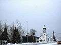
Trinity Bay church in Winter
-
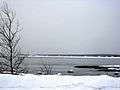
View of the western section of Trinity Bay
References
- 1 2 Reference number 3121 of the Commission de toponymie du Québec (French)
- 1 2 3 Geographic code 96005 in the official Répertoire des municipalités (French)
- 1 2 3 "(Code 2496005) Census Profile". 2011 census. Statistics Canada. 2012.
- ↑ "Baie-Trinité (Municipalité de village)" (in French). Commission de toponymie du Québec. Retrieved 2010-07-12.
- ↑ Statistics Canada: 1996, 2001, 2006 census, 2011
- ↑ Statistics Canada 2006 Census - Baie-Trinité community profile
 |
Port-Cartier | | ||
| Rivière-aux-Outardes Godbout |
|
Gulf of Saint Lawrence | ||
| ||||
| | ||||
| Saint Lawrence River |
| Cities & Towns | |
|---|---|
| Municipalities | |
| Parishes | |
| Villages | |
| Unorganized Territories | |
| Native reserves (Unassociated with RCM) | |
| |