Balta, Kansas
| Balta, Kansas | |
|---|---|
| Unincorporated area | |
 Balta, Kansas  Balta, Kansas | |
| Coordinates: 38°53′5″N 98°54′56″W / 38.88472°N 98.91556°WCoordinates: 38°53′5″N 98°54′56″W / 38.88472°N 98.91556°W | |
| Country | United States |
| State | Kansas |
| County | Russell |
| Elevation | 1,877 ft (572 m) |
| Time zone | Central (CST) (UTC-6) |
| • Summer (DST) | CDT (UTC-5) |
| ZIP code | 67665 |
| Area code(s) | 785 |
| GNIS feature ID | 484725[1] |
Balta is an unincorporated area in Russell Township, Russell County, Kansas, United States.[2] It is the site of an agricultural cooperative facility, but there is no community or settlement at Balta.[3]
History
Balta was once a stop on the Union Pacific Railroad.[4]
Geography
Balta is located at 38°53′5″N 98°54′56″W / 38.88472°N 98.91556°W (38.8847338, -98.9156421), at an elevation of 1,877 feet (572 m).[1] It lies 0.75 miles (1.21 km) north of Fossil Creek, part of the Smoky Hill River watershed, in the Smoky Hills region of the Great Plains. Balta is roughly 1.4 miles (2.3 km) north of Interstate 70 and 3 miles (4.8 km) west of Russell, the county seat.
References
- 1 2 U.S. Geological Survey Geographic Names Information System: Balta, Kansas
- ↑ "General Highway Map - Russell County, Kansas" (PDF). Kansas Department of Transportation. 2010-10-01. Retrieved 2011-02-22.
- ↑ "Google Maps Street View - Balta, KS". Retrieved 2014-09-17.
- ↑ "Stouffer's Railroad Map of Kansas". Kansas Memory. Kansas Historical Society. 1918. Retrieved 2014-09-17.
Municipalities and communities of Russell County, Kansas, United States | ||
|---|---|---|
| Cities | 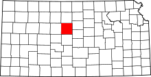 | |
| Townships | ||
| Unincorporated communities | ||
| Footnotes | ‡This populated place also has portions in an adjacent county or counties | |
This article is issued from Wikipedia - version of the 7/31/2016. The text is available under the Creative Commons Attribution/Share Alike but additional terms may apply for the media files.