Barn Bluff (Red Wing, Minnesota)
|
Barn Bluff | |
|
Eastern end of Barn Bluff | |
 | |
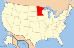
| Location | Red Wing, Minnesota |
|---|---|
| Coordinates | 44°34′12″N 92°31′38″W / 44.57000°N 92.52722°WCoordinates: 44°34′12″N 92°31′38″W / 44.57000°N 92.52722°W |
| NRHP Reference # | 90001165 [1] |
| Added to NRHP | August 3, 1990 |
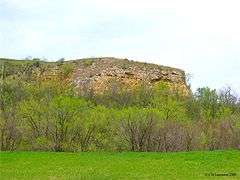
Barn Bluff is a bluff along the Mississippi River in Red Wing, Minnesota, United States. The bluff is associated with Dakota legend from hundreds of years ago. During the 19th century, the bluff functioned as a visual reference for explorers and travelers.[2] The bluff overlooks the downtown area and towers about 400 feet (120 m) above the Mississippi River with an extensive view of Lake Pepin to the south. It is one of hundreds of bluffs in the Driftless Area, which covers parts of Wisconsin, Iowa, and Illinois, in addition to the southeastern toe of Minnesota.
Geology

Most of the bluff is displaced approximately 40 metres (131 ft) upwards relative to the adjoining bedrock along the Red Wing Fault, which transects the bluff near its south face. It is composed of early Paleozoic rocks, including Ordovician dolomite and sandstone atop Cambrian shale, siltstone and greensand at its base, deposited by early Paleozoic seas. The aggregates left by glacial drift and wind-deposited loess form a 20 metres (66 ft) cap deposited some 450 million years after the bedrock beneath. Barn Bluff was cut off from nearby uplands by an earlier course of the ancestral Mississippi along which US Highway 61 now runs, and it was an island during the massive outflow of Glacial River Warren which carved much of the present Upper Mississippi Valley.[3][4]
History
Stephen H. Long climbed the bluff during his 1819 mapping expedition, describing it as, "the sublime and beautiful here blended in a most enchanting manner." Explorer Jonathan Carver, describing the view from Barn Bluff, wrote, "The most beautiful prospect that imagination can form [...] Verdant plains, fruitful meadows, and numerous islands abound with the most varied trees. [...] But above all, reaching as far as the eye can extend, is the majestic, softly flowing river." [5]
The bluff was used as a limestone quarry for about 40 years until citizens protested the defacing of the bluff. The quarrying operation was shut down in 1908. In 1910, the land was donated to the city as a park.[6][7]
Name and Description
The name of Barn Bluff, according to Upham, "is translated from its early French name, La Grange, meaning the Barn, which refers to its prominence as a lone, high, and nearly level-crested bluff, quite separated from the side bluffs of the valley, and therefore conspicuously seen at a distance of many miles up the valley and yet more observable from boats passing along Lake Pepin. Maj. Long in 1817 ascended this hill or bluff, called in his journal "the Grange or Barn," of which he wrote: 'From the summit of the Grange the view of the surrounding scenery is surpassed, perhaps, by very few, if any, of a similar character that the country and probably the world can afford. The sublime and beautiful are here blended in the most enchanting manner.'" [8]
Legend
Dakota legend about the bluff tells that hundreds of years ago, a mountain twice as big stood in the place of Barn Bluff. The residents of two Dakota villages disputed the possession of the mountain. As a compromise, the Great Spirit divided the mountain into two parts. One part stayed in Red Wing, and the other part was moved downstream to Winona, Minnesota, where it is known as Sugar Loaf.[5]
Today

Today Barn Bluff is thickly forested with deciduous trees at the top, with grass growing all throughout the base, and ringed all around by limestone cliffs, except at the northern end where steps have been built and carved into the bluff. Using these steps, hikers can ascend Barn Bluff with a strenuous but relatively brief hike.
References
- ↑ National Park Service (2007-01-23). "National Register Information System". National Register of Historic Places. National Park Service.
- ↑ Nord, Mary Ann (2003). The National Register of Historic Places in Minnesota. Minnesota Historical Society. ISBN 0-87351-448-3.
- ↑ Ojakangas, Richard W.; Matsch, Charles L. (1982). "Minnesota's Geology". Minneapolis: University of Minnesota Press: 240–241. ISBN 0-8166-0953-5.
- ↑ Sansome, Constance Jefferson (1983). "Minnesota Underfoot: A Field Guide to the State's Outstanding Geologic Features". Stillwater, MN: Voyageur Press: 82–83. ISBN 0-89658-036-9.
- 1 2 compiled by Sarah P. Rubinstein. (2003). Minnesota History Along the Highways: A Guide to Historic Markers and Sites. Saint Paul, Minnesota: Minnesota Historical Society. ISBN 0-87351-456-4.
- ↑ Interpretive sign erected by the City of Red Wing
- ↑ Interpretive sign erected by the Red Wing Lions Club, 1978
- ↑ Upham, Warren (2001). Minnesota Place Names, A Geographical Encyclopedia, 3rd Edition. Saint Paul, Minnesota: Minnesota Historical Society. p. 216. ISBN 0-87351-396-7.
External links
| Wikimedia Commons has media related to Barn Bluff (Red Wing, Minnesota). |