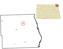
Bathgate, North Dakota
| Bathgate, North Dakota | |
|---|---|
| City | |
|
North Dakota School for the Blind in 1908 | |
 | |
| Coordinates: 48°52′52″N 97°28′21″W / 48.88111°N 97.47250°WCoordinates: 48°52′52″N 97°28′21″W / 48.88111°N 97.47250°W | |
| Country | United States |
| State | North Dakota |
| County | Pembina |
| Area[1] | |
| • Total | 0.27 sq mi (0.70 km2) |
| • Land | 0.27 sq mi (0.70 km2) |
| • Water | 0 sq mi (0 km2) |
| Elevation | 817 ft (249 m) |
| Population (2010)[2] | |
| • Total | 43 |
| • Estimate (2015)[3] | 41 |
| • Density | 159.3/sq mi (61.5/km2) |
| Time zone | Central (CST) (UTC-6) |
| • Summer (DST) | CDT (UTC-5) |
| ZIP code | 58216 |
| Area code(s) | 701 |
| FIPS code | 38-05260 |
| GNIS feature ID | 1027828[4] |
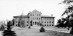
Bathgate is a city in Pembina County, North Dakota, United States. It sits on the banks of the Tongue River. The population was 43 at the 2010 census.[5] Bathgate was founded in 1881. In 1908 the North Dakota School for the Blind was placed in Bathgate. The building still stands and is now occupied by a publishing company.[6] Bathgate was the childhood home of former world-champion speed skater and figure skater, Norval Baptie.[7]
History
Bathgate was originally called Bayview, and under the latter name was laid out in 1879.[8] The present name, after Bathgate, Scotland, was adopted in 1881.[9] A post office called Bathgate has been in operation since 1881.[10]
Geography
Bathgate is located at 48°52′52″N 97°28′21″W / 48.88111°N 97.47250°W (48.881014, -97.472429).[11]
According to the United States Census Bureau, the city has a total area of 0.27 square miles (0.70 km2), all of it land.[1]
Demographics
| Historical population | |||
|---|---|---|---|
| Census | Pop. | %± | |
| 1890 | 377 | — | |
| 1900 | 641 | 70.0% | |
| 1910 | 328 | −48.8% | |
| 1920 | 352 | 7.3% | |
| 1930 | 292 | −17.0% | |
| 1940 | 312 | 6.8% | |
| 1950 | 209 | −33.0% | |
| 1960 | 175 | −16.3% | |
| 1970 | 133 | −24.0% | |
| 1980 | 67 | −49.6% | |
| 1990 | 75 | 11.9% | |
| 2000 | 66 | −12.0% | |
| 2010 | 43 | −34.8% | |
| Est. 2015 | 41 | [12] | −4.7% |
| U.S. Decennial Census[13] 2015 Estimate[3] | |||
2010 census
As of the census[2] of 2010, there were 43 people, 22 households, and 11 families residing in the city. The population density was 159.3 inhabitants per square mile (61.5/km2). There were 25 housing units at an average density of 92.6 per square mile (35.8/km2). The racial makeup of the city was 95.3% White and 4.7% Native American. Hispanic or Latino of any race were 2.3% of the population.
There were 22 households of which 27.3% had children under the age of 18 living with them, 40.9% were married couples living together, 4.5% had a female householder with no husband present, 4.5% had a male householder with no wife present, and 50.0% were non-families. 45.5% of all households were made up of individuals and 22.7% had someone living alone who was 65 years of age or older. The average household size was 1.95 and the average family size was 2.64.
The median age in the city was 49.5 years. 18.6% of residents were under the age of 18; 2.4% were between the ages of 18 and 24; 23.3% were from 25 to 44; 37.2% were from 45 to 64; and 18.6% were 65 years of age or older. The gender makeup of the city was 51.2% male and 48.8% female.
2000 census
As of the census of 2000, there were 66 people, 25 households, and 18 families residing in the city. The population density was 206.2 people per square mile (79.6/km²). There were 28 housing units at an average density of 87.5 per square mile (33.8/km²). The racial makeup of the city was 83.33% White, 13.64% Native American, and 3.03% from two or more races.
There were 25 households out of which 32.0% had children under the age of 18 living with them, 68.0% were married couples living together, 4.0% had a female householder with no husband present, and 28.0% were non-families. 28.0% of all households were made up of individuals and 8.0% had someone living alone who was 65 years of age or older. The average household size was 2.64 and the average family size was 3.28.
In the city the population was spread out with 30.3% under the age of 18, 6.1% from 18 to 24, 33.3% from 25 to 44, 18.2% from 45 to 64, and 12.1% who were 65 years of age or older. The median age was 36 years. For every 100 females there were 78.4 males. For every 100 females age 18 and over, there were 84.0 males.
The median income for a household in the city was $36,250, and the median income for a family was $51,250. Males had a median income of $37,750 versus $17,083 for females. The per capita income for the city was $13,593. There were 8.7% of families and 4.5% of the population living below the poverty line, including no under eighteens and 33.3% of those over 64.
In popular culture
Bathgate was featured in the Coen brothers' 1996 film Fargo as a fictional version of Brainerd, Minnesota.
References
- 1 2 "US Gazetteer files 2010". United States Census Bureau. Archived from the original on 2012-01-24. Retrieved 2012-06-14.
- 1 2 "American FactFinder". United States Census Bureau. Retrieved 2012-06-14.
- 1 2 "Population Estimates". United States Census Bureau. Retrieved July 13, 2016.
- ↑ "US Board on Geographic Names". United States Geological Survey. 2007-10-25. Retrieved 2008-01-31.
- ↑ "2010 Census Redistricting Data (Public Law 94-171) Summary File". American FactFinder. United States Census Bureau. Archived from the original on 21 July 2011. Retrieved 2 May 2011.
- ↑ "Start of our School". Retrieved 2007-11-19.
- ↑ Helm, Merry (2003-11-26). "Norval Baptie". Dakota Datebook. Prairie Public Radio. Archived from the original on 2008-01-10. Retrieved 2007-11-20.
- ↑ Olstad, Geneva Roth (2000). Main Street, North Dakota. Arcadia Publishing. p. 17. ISBN 978-0-7385-0760-6.
- ↑ "Cities". County of Pembina, North Dakota. Archived from the original on February 18, 2015. Retrieved 26 October 2015.
- ↑ "Pembina County". Jim Forte Postal History. Retrieved 25 October 2015.
- ↑ "US Gazetteer files: 2010, 2000, and 1990". United States Census Bureau. 2011-02-12. Retrieved 2011-04-23.
- ↑ "Annual Estimates of the Resident Population for Incorporated Places: April 1, 2010 to July 1, 2015". Retrieved July 2, 2016.
- ↑ United States Census Bureau. "Census of Population and Housing". Archived from the original on May 11, 2015. Retrieved August 30, 2013.
External links
Municipalities and communities of Pembina County, North Dakota, United States | ||
|---|---|---|
| Cities | 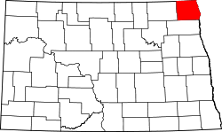 | |
| Townships |
| |
| Unincorporated communities | ||