Bayou Meto, Lonoke County, Arkansas
| Bayou Meto, Arkansas | |
|---|---|
| Unincorporated community | |
 Bayou Meto, Arkansas Bayou Meto's position in Arkansas. | |
| Coordinates: 34°42′31″N 91°52′17″W / 34.70861°N 91.87139°WCoordinates: 34°42′31″N 91°52′17″W / 34.70861°N 91.87139°W | |
| Country |
|
| State |
|
| County | Lonoke |
| Elevation | 68 m (223 ft) |
| Time zone | Central (CST) (UTC-6) |
| • Summer (DST) | CDT (UTC-5) |
| GNIS feature ID | 61176 |
Bayou Meto, Arkansas is an unincorporated community in Lonoke County, Arkansas, United States.[1] The community is located south of Lonoke.[2]
References
- ↑ "Feature Detail Report for: Arkansas, Arkansas." USGS. U.S. Geological Survey Geographic Names Information System: Bayou Meto, Lonoke County, Arkansas Retrieved December 9, 2010.
- ↑ Arkansas Atlas and Gazetteer (Map) (Second ed.). DeLorme. § 42.
Municipalities and communities of Lonoke County, Arkansas, United States | ||
|---|---|---|
| Cities | 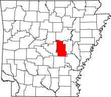 | |
| Towns | ||
| CDP | ||
| Townships |
| |
| Unincorporated communities | ||
| Footnotes | ‡This populated place also has portions in an adjacent county or counties | |
This article is issued from Wikipedia - version of the 3/7/2016. The text is available under the Creative Commons Attribution/Share Alike but additional terms may apply for the media files.