Beaverdam Creek Archaeological Site
 Shown within Georgia (U.S. state) | |
| Location |
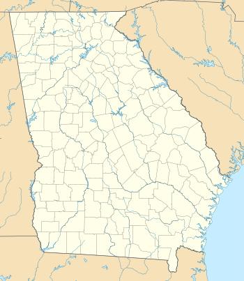
Elbert County, Georgia, |
|---|---|
| Region | Elbert County, Georgia |
| Coordinates | 34°4′50.66″N 82°39′50.29″W / 34.0807389°N 82.6639694°W |
| History | |
| Founded | 1200 CE |
| Abandoned | 1500 CE |
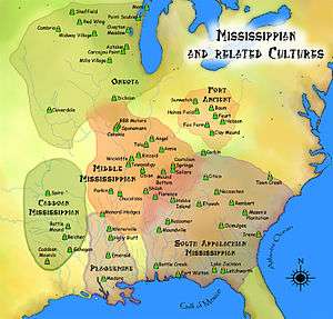
| Cultures | South Appalachian Mississippian culture |
| Architecture | |
| Architectural styles | platform mound |
The Beaverdam Creek Archaeological Site, (9 EB 85), is an archaeological site located on a floodplain of Beaverdam Creek in Elbert County, Georgia approximately 0.8 km from the creek's confluence with the Savannah River, and is currently inundated by the Richard B. Russell Lake. The site consisted of a platform mound and an associated village site. Beaverdam Creek is thought to have been the center of a Mississippian culture simple chiefdom with a small resident population. The primary period of mound construction and village occupation dated to the regional Savannah period of the Middle Mississippian period, specifically 1200–1300 CE, with the site's abandonment occurring sometime after 1300.[1] The mound was 1.5 metres (4.9 ft) high, and its base measured 25 metres (82 ft) by 25 metres (82 ft). The village boundaries were delineated as 15,000 square meters.[2]
Excavation
- 1969: The site was first observed professionally by Brooks Hutto, who reported that at least two decades of sustained looting by pot-hunters had damaged the mound and village site considerably.[2]
- 1971: Joseph R. Caldwell of the University of Georgia conducted an eight-week field-school at the site, but a series of unpredictable and unfortunate events including dismal weather, pot-hunting raids by looters and the theft of equipment led to a disappointing excavation season.[2]
- 1973: Chung Ho Lee, following the passing of Joseph R. Caldwell, wrote a report summarizing the 1971 excavations. Lee concluded that the mound was a multistage platform mound constructed during the Savannah period, and that ceremonial grave goods (including a copper-covered celt) were included in the mound.[2]
- 1977: The Institute of Archaeology and Anthropology of the University of South Carolina conducted survey and testing that indicated a village midden was present and extended some 50 metres (160 ft) from the mound.[2]
- 1979: At the behest of the U.S. Army Corps of Engineers, the Thunderbird Research Corporation undertook to more accurately delineate the village boundaries through shovel tests, augering and limited excavation.[2]
- 1980: Excavations by Gardner and Rappleye revealed early Lamar period (1375–1475 CE) material in the midden, and on this evidence proposed a primary use period for the site during this time. This conflicting hypothesis prompted them to recommend to the U.S. Army Corps of Engineers that the mound be completely excavated, the village midden be extensively tested and that the floodplain to the north and southeast be thoroughly surveyed.[2]
- 1980-1981: With funds provided by The U.S. Army Corps of Engineers, the University of Georgia Research Foundation,Inc. and the Archaeological Services Branch of the National Park Service began excavations as mitigation under Section 106 of the National Historic Preservation Act for the construction of the Richard B. Russell Dam and Reservoir. These excavations were led David J. Hally and James C. Rudolph, and created copious amounts of information concerning mound construction stages, subsistence, social structure as well as evidence for cooking, tool making, trash disposal and one possible village structure.[2]
Site description
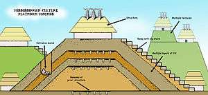
The mound construction stages show a growing complexity in social structure and hierarchy at the site. Beginning as a midden 15–20 cm thick, the mound grew through a succession of two earthlodge structures, a possible flooding event and four subsequent mound building stages. The earthlodges were superimposed square structures surrounded by significantly high earthen embankments. The interment of a high status individual, known as Burial 2, occurred prior to the construction of the second earthlodge after the partial dismantling of the first. These structures were then covered by a layer of water-lain sand that is interpreted as a possible flooding event. Following this, four separate platform-mound building events were recorded by Hally and Rudolph. The mounds were topped by free-standing structures of possible political/ceremonial importance. Mound Stage 2 also saw the addition of a 2.25 metres (7.4 ft) wide ramp with the appearance of steps.[2]
There were 46 burials (16 adult females, 15 adult males, 13 children and 3 of indeterminate sex) excavated by Hally and Rudolph that exhibit marked differentiation of social status. Burial 2 was replete with grave goods. The inclusion of children into mound mortuary has been interpreted as evidence for ascribed status, and is considered a marker of increased hierarchical differentiation.[3] Burial 2 grave goods included more than 7,000 mussel shell beads and a copper headpiece and ear spools.[4]
The well-preserved food remains excavated from village midden provides for a detailing of a diversified and generalized subsistence strategy rather that a more focal strategy employed by the inhabitants. The remains included resources from the upland and bottomland forest, river shoals, and agricultural practices on the fertile floodplain, and included maize, squash, sumpweed, sunflower, maypops, grapes, persimmons, acorns, hickory nuts, grass seeds and greens as floral resources, as well, as faunal resources such as deer, rabbits, squirrels, raccoons, beaver, turkey and riverine foods including turtle, catfish, gar, sucker and bass.[2]
The excavations conducted at Beaverdam Creek have helped to clarify two important categories of study in Mississippian period chiefdoms, namely how is a chiefdom quantified and what were subsistence strategies employed by a chiefdom once it has been quantified? The exchange of earthlodges for structures atop platform mounds coupled with Burial 2 and the inclusion of children argues for the emergence of the site as a stratified chiefdom,[1] and the floral and faunal evidence indicate a highly diversified subsistence strategy.
Inundation
The Richard B. Russell Dam constructed on the Savannah River inundated site 9EB85 as the filling of the Richard B. Russell Reservoir began in October 1983.
See also
References
- 1 2 Anderson, David G. (1996). "Chiefly Cycling and Large-Scale Abandonments as Viewed from the Savannah River Basin". In John F. Scarry. Political Structure and Change in the Prehistoric Southeastern United States. Gainesville: University Press of Florida. pp. 150–191.
- 1 2 3 4 5 6 7 8 9 10 Rudolph, James L.; Hally, David J. (1985). "Archaeological Investigations at the Beaverdam Creek Site (9EB85) Elbert County, Georgia". Russell Papers. Atlanta: National Park service, Interagency Archaeological Services.
- ↑ King, Adam (2003). Etowah: the Political History of a Chiefdom Capital. Tuscaloosa: The University of Alabama Press.
- ↑ "Significant Archaeological Sites". NPS.gov. Archived from the original on 2012-10-23. Retrieved 2012-11-23.
External links
| Archaeological cultures |
|
|---|---|
| Archaeological sites |
|
| Human remains | |
| Miscellaneous |
|
| |
| Topics | |
|---|---|
| Lists by states |
|
| Lists by insular areas | |
| Lists by associated states | |
| Other areas | |
| |