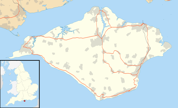
Bembridge
| Bembridge | |
 Bembridge Lifeboat Station |
|
 Bembridge |
|
| Population | 3,688 (2011)[1] |
|---|---|
| OS grid reference | SZ643882 |
| Unitary authority | Isle of Wight |
| Ceremonial county | Isle of Wight |
| Region | South East |
| Country | England |
| Sovereign state | United Kingdom |
| Post town | BEMBRIDGE |
| Postcode district | PO35 0 |
| Dialling code | 01983 |
| Police | Hampshire |
| Fire | Isle of Wight |
| Ambulance | Isle of Wight |
| EU Parliament | South East England |
| UK Parliament | Isle of Wight |
|
|
Coordinates: 50°41′23″N 1°05′20″W / 50.6897°N 1.0889°W
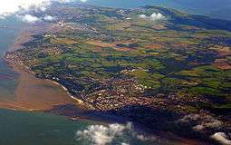
Bembridge is a village and civil parish[2] located on the easternmost point of the Isle of Wight. It had a population of 3,848 according to the 2001 census of the United Kingdom,[3] leading to claims by residents that Bembridge is the largest village in England.[4] Bembridge is home to many of the Island's wealthiest residents. The population had reduced to 3,688 at the 2011 Census.
Bembridge sits at the extreme eastern point of the Isle of Wight. Prior to land reclamation the area of Bembridge and Yaverland was almost an island unto itself, separated from the remainder of the Isle of Wight by Brading Haven. Prior to the Victorian era Bembridge was a collection of wooden huts and farmhouses, which only consolidated into a true village with the building of the church in 1827 (later rebuilt in 1846). The historical heart of the village is located close to the church in the north of the village, consisting of a number of shops, pubs and restaurants, along with the Village Hall and site of the former Parish Council hall. Bembridge Library serves the community and there is a local museum in the same location.
The Lane End district is located in the east of the village. It is largely composed of modern bungalows and a small shopping area which includes a Co-Op store. The lane comes to an end at the beach, where Bembridge Lifeboat station and the Bembridge Coast Hotel are situated. Formerly, many of the bungalows were on the land of a cottage where Cecily Cardew lived, after whom an Oscar Wilde character was named. Moving inland from Lane End one finds Bembridge C of E Primary School, along with the local community centre, which are connected by a large recreational playing field.
The Royal Isle of Wight Golf Club (now defunct) was located at St Helens Duver, across the harbour from Bembridge. The club was formed in 1882. It closed in the 1960s.[5]
Facilities
Bembridge is a local service centre, hosting Bembridge C of E Primary School (see Education on the Isle of Wight for more information on the use of this term), a post office, several shops located in two main areas, and Methodist, Anglican and Catholic churches. It is also the location of a local fire station, (crewed by a team of retained firemen), and a Royal National Lifeboat Institution (RNLI) lifeboat station.[6]
Bembridge Airport is a local airport with a concrete runway, and is located close to the Windmill to the south-west of the village proper heading towards Yaverland.
The war memorial was designed by local architect, Percy Stone (1856–1934).[7]
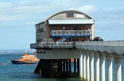
Lifeboat station
The RNLI station is particularly significant, as it extends into the sea to the east of the village. Here lies the notorious "Bembridge Ledge", a large, rocky outcrop which poses a major threat to passing boats.[8] Although it is private sailing yachts which are most at risk, a wide variety of boats commonly run aground here, especially in the often stormy weather conditions which affect the Solent during winter months. A former Bembridge lifeboat, the RNLB Jesse Lumb (ON 822), is part of the National Historic Fleet, and exhibited at Imperial War Museum Duxford.[9]
The current offshore boathouse was completed in Autumn 2010 by BAM Nuttall and Ecochoice and houses a new Tamar class boat, the 'Alfred Albert Williams'.[10] A complete new concrete walkway was built, and the new station is made completely of naturally durable timber. The Inshore lifeboat station was rebuilt in 2014, and the interior of the offshore boathouse is accessible to visitors during set days when the station isn't on alert. The original Victorian boathouse also survives, and is currently used as the station's shop.
Coastguard lookout
Close to the lifeboat station lies a coastguard lookout. Positioned at a high elevation, this offers views of the Solent meeting the English Channel to the east of the Isle of Wight. From this vantage point one is able to view a variety of watercraft year round, although there is more marine traffic in the summer.
Bembridge Windmill
.jpg)
Bembridge Windmill, the only remaining windmill on the Isle of Wight, is located to the west of the village. Dating from around 1700, it is a National Trust property generally open from April to October.[11]
Politics
Bembridge is currently represented on the Isle of Wight Council by the two members of the ward of Bembridge, St. Helens and Brading.
Bembridge is governed by a Parish council of 12 members. For parish council elections the village is divided into two wards, the North and South, each electing six members to the body. The parish council has succeeded in obtaining Lottery funding for improvements to the village recently, including a play-park in Steyne Park. It is also one of the few Parish Councils that has a village centre office open 5 days a week.
Twinning
- Bembridge is twinned with Plédran, Brittany, France but in name only as the federation has lapsed through non-use.
Public transportation
Public transport to Newport, Ryde and Sandown is provided by Southern Vectis bus route 8.[12]
Bembridge railway station, which was located in the north-west of the village close to the harbour served the village, with services to Brading, until 1953. The station became derelict and was demolished around 1970.
See also
Bembridge Boarding Campus
Bembridge Boarding Campus, formerly Bembridge School, is now owned by Ryde School with Upper Chine, whose lessees run Kingswood Centre. Kingswood Centre operates Kingswood during term-time and Camp Beaumont during school holidays. However it is closed for a few weeks in the winter.
Ryde School with Upper Chine have their Boarders boarding at Bembridge Boarding Campus.
New House Bembridge School is a Grade II Listed Building.
Bembridge School Chapel is a Grade IIGV Listed Building with Edward Woore stained glass to beautify it.
References
- ↑ "Civil Parish population 2011". Retrieved 18 October 2015.
- ↑ "English Parishes and Welsh communities N&C 2004". www.statistics.gov.uk. 2004. Archived from the original on 9 January 2007. Retrieved 3 May 2007.
- ↑ "Local area population and ethnicity – Bembridge on the Isle of Wight". www.town-guides.org. Retrieved 29 September 2008.
- ↑ "Places to stay on the Isle of Wight – Bembridge". www.sunnycottcaravanpark.co.uk. Archived from the original on 16 September 2008. Retrieved 29 September 2008.
- ↑ “Royal Isle of Wight Golf Club”, "Golf's Missing Links".
- ↑ "Wightindex – Bembridge Village Guide". www.wightindex.com. Retrieved 29 September 2008.
- ↑ "Bembridge War Memorial". Memorials & Monuments on the Isle of Wight. 24 July 2009. Retrieved 20 November 2009.
- ↑ "Geograph British Isles – Bembridge Ledge". www.geograph.org.uk. Retrieved 29 September 2008.
- ↑ "National Register of Historic Vessels: Jesse Lumb". National Historic Ships. 2011. Retrieved 1 August 2011.
- ↑ "HRH Princess Anne opens new lifeboat station". iwchronicle.co.uk. 16 August 2011. Retrieved 29 August 2011.
- ↑ "National Trust – Bembridge Windmill". www.nationaltrust.org.uk. Archived from the original on 11 October 2008. Retrieved 29 September 2008.
- ↑ "Southern Vectis bus routes". Southern Vectis. Archived from the original on 30 November 2009. Retrieved 20 December 2009.
External links
| Wikimedia Commons has media related to Bembridge. |
 Bembridge travel guide from Wikivoyage
- Bembridge Parish Council
Isle of Wight Portal | |
| Unitary authorities | |
| Major settlements | |
| Rivers | |
| Topics | |