Bentonville, Virginia
| Bentonville, Virginia | |
|---|---|
| Unincorporated community | |
|
Bentonville Primitive Baptist Church | |
 Bentonville, Virginia  Bentonville, Virginia | |
| Coordinates: 38°49′54″N 78°18′59″W / 38.83167°N 78.31639°WCoordinates: 38°49′54″N 78°18′59″W / 38.83167°N 78.31639°W | |
| Country | United States |
| State | Virginia |
| County | Warren |
| Elevation | 748 ft (228 m) |
| Time zone | Eastern (EST) (UTC-5) |
| • Summer (DST) | EDT (UTC-4) |
| ZIP code | 22610 |
| Area code(s) | 540 |
| GNIS feature ID | 1492556[1] |
.jpg)
Bentonville is an unincorporated community in Warren County, Virginia, United States. Bentonville is located along U.S. Route 340 8.9 miles (14.3 km) southwest of Front Royal. Bentonville has a post office with ZIP code 22610.[2][3]
| Wikimedia Commons has media related to Bentonville, Virginia. |
References
- ↑ "Bentonville". Geographic Names Information System. United States Geological Survey.
- ↑ United States Postal Service (2012). "USPS - Look Up a ZIP Code". Retrieved 2012-02-15.
- ↑ "Postmaster Finder - Post Offices by ZIP Code". United States Postal Service. Retrieved December 27, 2012.
Municipalities and communities of Warren County, Virginia, United States | ||
|---|---|---|
| Town | 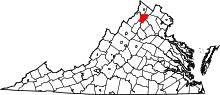 | |
| CDPs | ||
| Unincorporated communities |
| |
| Footnotes | ‡This populated place also has portions in an adjacent county or counties | |
This article is issued from Wikipedia - version of the 11/21/2016. The text is available under the Creative Commons Attribution/Share Alike but additional terms may apply for the media files.