Bhor Ghat
| Bhor Ghat भोर घाट | |
|---|---|
|
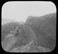
Bhor Ghat in 1870 | |
| Elevation | 441 metres (1,447 ft) [1] |
| Location | Maharashtra, India |
| Range | Sahyadri |
| Coordinates | 18°46′00″N 73°22′00″E / 18.7667°N 73.3667°ECoordinates: 18°46′00″N 73°22′00″E / 18.7667°N 73.3667°E |
 Location of Bhor Ghat | |
.jpg)
Bhor Ghat or Bor Ghat, Bhore Ghaut,[2][3] is a mountain passage located between Palasdari and Khandala in Maharashtra, India along the railway line and between Khopoli and Khandala for road Old Mumbai Pune Road and the Mumbai Pune Expressway. Situated on the crest of the Western Ghat mountain ranges, Bhor Ghat is noted for its scenic and dense woods.
Rail
Bhor Ghat | ||||||||||||||||||||||||||||||||||||||||||||||||||||||||||||||||||||||||||||||||||||||||||||||||||||||||||||||||||||||||||||||||||||||||||||||||||||||||||||||||||||||||||||||||||||||||||||||||||||||||||||||||||||||||||||||||||||||||||||||||||||||||||||||||||||||||||||||||||||||||||||||||||||||||||||||||||||||||||||||||||||||||||||||||||||||||||||||||||||||||||||||||||||||||||||||||||||||||||||||||||||||
|---|---|---|---|---|---|---|---|---|---|---|---|---|---|---|---|---|---|---|---|---|---|---|---|---|---|---|---|---|---|---|---|---|---|---|---|---|---|---|---|---|---|---|---|---|---|---|---|---|---|---|---|---|---|---|---|---|---|---|---|---|---|---|---|---|---|---|---|---|---|---|---|---|---|---|---|---|---|---|---|---|---|---|---|---|---|---|---|---|---|---|---|---|---|---|---|---|---|---|---|---|---|---|---|---|---|---|---|---|---|---|---|---|---|---|---|---|---|---|---|---|---|---|---|---|---|---|---|---|---|---|---|---|---|---|---|---|---|---|---|---|---|---|---|---|---|---|---|---|---|---|---|---|---|---|---|---|---|---|---|---|---|---|---|---|---|---|---|---|---|---|---|---|---|---|---|---|---|---|---|---|---|---|---|---|---|---|---|---|---|---|---|---|---|---|---|---|---|---|---|---|---|---|---|---|---|---|---|---|---|---|---|---|---|---|---|---|---|---|---|---|---|---|---|---|---|---|---|---|---|---|---|---|---|---|---|---|---|---|---|---|---|---|---|---|---|---|---|---|---|---|---|---|---|---|---|---|---|---|---|---|---|---|---|---|---|---|---|---|---|---|---|---|---|---|---|---|---|---|---|---|---|---|---|---|---|---|---|---|---|---|---|---|---|---|---|---|---|---|---|---|---|---|---|---|---|---|---|---|---|---|---|---|---|---|---|---|---|---|---|---|---|---|---|---|---|---|---|---|---|---|---|---|---|---|---|---|---|---|---|---|---|---|---|---|---|---|---|---|---|---|---|---|---|---|---|---|---|---|---|---|---|---|---|---|---|---|---|---|---|---|---|---|---|---|---|---|---|---|---|---|---|---|---|---|---|---|---|---|---|---|---|---|---|---|---|---|---|---|---|---|---|---|---|---|---|---|
Legend
| ||||||||||||||||||||||||||||||||||||||||||||||||||||||||||||||||||||||||||||||||||||||||||||||||||||||||||||||||||||||||||||||||||||||||||||||||||||||||||||||||||||||||||||||||||||||||||||||||||||||||||||||||||||||||||||||||||||||||||||||||||||||||||||||||||||||||||||||||||||||||||||||||||||||||||||||||||||||||||||||||||||||||||||||||||||||||||||||||||||||||||||||||||||||||||||||||||||||||||||||||||||||
The Bhor railway ghat cuts a distance of 21 km between Khandala and Palasdari. There are 28 tunnels across the railway ghat. This ghat comes under the proposed Golden Quadrilateral Freight Corridors. During construction of this ghat almost 25,000 workers lost their lives due to steepness of this ghat.
- Use of bankers
The rail ghat has some stiff portions which are unable to climb the train with a single locomotive. Hence bank locomotive (bankers) are used. These bankers are attached behind the train at Karjat from Mumbai to Pune and at Lonavala from Pune to Mumbai. Two or three bankers are attached per train depending on train length.
- Reversing Station
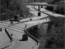
There used to be a reversing station on this ghat which trains of Great Indian Peninsula Railway (GIPR) used earlier. This was shutdown due to new tunnels on the ghat.[4] The reversing station was located between Monkey Hill and Khandala after tunnel no. 26. Today a famous point called Amrutanjan point is located here which gives a panoramic view of Khopoli. During night time lights of Khopoli can be seen from here.[5]
| Railway stations on Bhor Ghat | ||||||
|---|---|---|---|---|---|---|
| # | Station Name | Description | km | |||
| English | Marathi | Station Code | ||||
| 1 | Palasdari | पळसदरी | PDI | Start | 0 | |
| 2 | Thakurvadi | ठाकुरवाडी | TKW | Minor Halt | 9 | |
| 3 | Monkey Hill | मंकी हिल | MNLC | Technical Halt, no tickets issued | 16 | |
| 4 | Khandala | खंडाळा | KAD | End | 21 | |
-
Reversing station, Bhor Ghat
Road
The Bhor road ghat cuts the Sahyadri range to join Khandala to Khopoli and handles traffic between Mumbai to Pune on the Old Mumbai Pune Road (Part of NH4 old no. now AH47) and on the Mumbai Pune Expressway (which is a part of Golden Quadrilateral of India). The Amrutanjan bridge is the oldest bridge on this ghat located on old Mumbai Pune road. This is the point where the express way crosses the old road. This ghat stretches almost 18 km between Khandala to Khopoli. There are 4 tunnels on the ghat on the Express Way. There is a point where the Mumbai - Pune Express way reach where there used to be old Great Indian Peninsula Railway (GIPR) reversing station. This point is near the Amrutanjan Bridge which is crossing point of the Mumbai - Pune Express way and Asian Highway 47 (AH47) from Gwalior to Bangalore. Landslides often occur during heavy monsoon leading to disturbance in Mumbai - Pune traffic due to road blocks. The government authorities are planning steps to prevent such blocks as Mumbai - Pune section is one of the busiest traffic section in India.
- Gallery
-
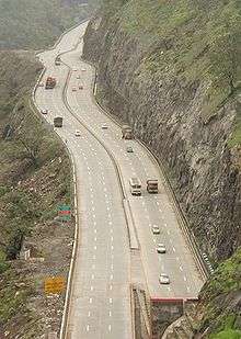
Bhor Ghat on Mumbai - Pune Expressway near Khandala
-

Entrance of the Madap tunnel on the Expressway
-
Expressway curves on Bhor Ghat
History
The discovery of a route to make a motorable pass in Bor Ghat came after information was provided by a local Dhangar tribesman called Shigroba. Later, the Great Indian Peninsula Railway laid a railway line from Mumbai to Pune. The section through Bhor Ghat with 28 tunnels, and old bridges was opened in 1863.[6] The Ghat opened Mumbai to the Deccan plains of Peninsular India.[7]
References
- ↑ Bhor Ghat
- ↑ The Indian Empire By William Wilson Hunter, p. 36
- ↑ "Archived copy". Archived from the original on 2008-05-01. Retrieved 2009-01-23.
- ↑ Bhor Ghat Reversing station
- ↑ Khandala Reversing Station
- ↑ Balkwill, Richard; Marshall, John (1993). The Guinness Book of Railway Facts and Feats (6th ed.). Enfield: Guinness Publishing. pp. 66–7. ISBN 978-0-85112-707-1.
- ↑ Rao, M.A. (1988). Indian Railways. New Delhi: National Book Trust. p. 15.
| Wikimedia Commons has media related to Bhor Ghat. |