Kumbharli Ghat
| Kumbharli Ghat | |
|---|---|
|
The Pass | |
| Elevation | 625 m (2,051 ft) |
| Traversed by | Karad–Chiplun State Highway |
| Location | Satara–Ratnagiri Districts, Maharashtra, India |
| Range | Western Ghats |
| Coordinates | 17°26′N 73°39′E / 17.43°N 73.65°E |
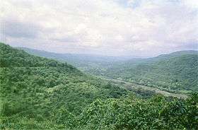
The Kumbharli Ghat is a mountain pass in Maharashtra, India that connects the coastal Ratnagiri District in Konkan region of Maharashtra with the Satara District in Desh region. It cuts across the Western Ghats range. It is one of few link roads between the Konkan and Ghatmaatha in Maharashtra. The road, a state highway, is at an average elevation of 625 m (2,051 ft). It links the cities of Chiplun (Ratnagiri district) and Karad (Satara district). Near the eastern end is the Koyna Dam.
Location
This ghat is on the Karad-Chiplun state highway. Also, this highway joins to the NH-4 near Umbraj. Malharpeth, Patan and Koyananagar are the major cities on this road.
This article is issued from Wikipedia - version of the 6/6/2016. The text is available under the Creative Commons Attribution/Share Alike but additional terms may apply for the media files.