Bjugn
| Bjugn kommune | |||
|---|---|---|---|
| Municipality | |||
 | |||
| |||
 Bjugn within Sør-Trøndelag | |||
| Coordinates: 63°48′24″N 9°53′53″E / 63.80667°N 9.89806°ECoordinates: 63°48′24″N 9°53′53″E / 63.80667°N 9.89806°E | |||
| Country | Norway | ||
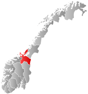
| County | Sør-Trøndelag | ||
| District | Fosen | ||
| Administrative centre | Botngård | ||
| Government | |||
| • Mayor (1999) | Arnfinn Astad (Ap) | ||
| Area | |||
| • Total | 383.80 km2 (148.19 sq mi) | ||
| • Land | 355.83 km2 (137.39 sq mi) | ||
| • Water | 27.97 km2 (10.80 sq mi) | ||
| Area rank | 243 in Norway | ||
| Population (2010) | |||
| • Total | 4,548 | ||
| • Rank | 199 in Norway | ||
| • Density | 12.8/km2 (33/sq mi) | ||
| • Change (10 years) | -3.2 % | ||
| Demonym(s) | Bjugning[1] | ||
| Time zone | CET (UTC+1) | ||
| • Summer (DST) | CEST (UTC+2) | ||
| ISO 3166 code | NO-1627 | ||
| Official language form | Bokmål | ||
| Website |
www | ||
|
| |||

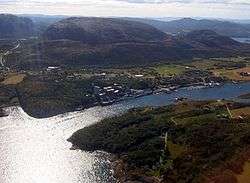
Bjugn is a municipality in Sør-Trøndelag county, Norway. It is part of the Fosen region. The village of Botngård is the administrative centre of Bjugn municipality. Other villages in Bjugn include Høybakken, Jøssund, Lysøysundet, Nes, Oksvoll, and Vallersund.[2]
General information
The municipality of Bjugn was established in 1853 when it was separated from the large municipality of Ørland. Initially, Bjugn had 2,903 residents. On 26 March 1870, a royal resolution moved an unpopulated part of Åfjord to Bjugn. On 1 January 1899, the western district of Nes (population: 1,285) and the southern district of Skjørn (population: 2,166) were separated from Bjugn. This left Bjugn with 1,256. On 1 January 1964, Nes, Jøssund, and the northern part of Stjørna were all merged with Bjugn to create a new, larger municipality of Bjugn. The population of Bjugn then increased from 1,240 to 4,940.[3] Bjugn was on the Robek-list in 2015.[4]
Name
The Old Norse form of the name was (also) Bjugn. The name is derived from bjúgr which means "bent", probably referring to the bent form of the local fjord, the Bjugnfjorden.[5]
Coat-of-arms
The coat-of-arms is from modern times. They were granted on 17 February 1989. The arms show a yellow rudder on a blue background, representing the historic importance of fishing in the municipality.[6]
Churches
The Church of Norway has three parishes (sokn) within the municipality of Bjugn. It is part of the Deanery (prosti) of Fosen and the Diocese of Nidaros.
| Parish (Sokn) | Church Name | Year Built | Location of the Church |
|---|---|---|---|
| Bjugn | Bjugn kirke | 1956 | Bjugn |
| Heggvik kirke | 1858 | Høybakken | |
| Jøssund | Jøssund kirke | 1875 | Jøssund |
| Nes | Nes kirke | 1878 | Nes |
| Tarva kapell | 1972 | Tarva |
Geography

The municipality of Bjugn is located on the Fosen peninsula on the mainland, plus many islands, including the Tarva islands. The Asenvågøy lighthouse is located in the far north of the municipality. The Bjugnfjorden and Stjørnfjord both are located partially in Bjugn.
Neighboring Bjugn is the municipality of Ørland to the southwest, Rissa to the south and southeast, and Åfjord to the northeast.
There are five nature reserves in Bjugn. Hildremsvatnet Nature Reserve is the largest at 23,441 decares (23.441 km2; 9.051 sq mi) and includes several nature types, among these are 9 localities identified as boreal rainforest (see Scandinavian coastal conifer forests).[7]
Sports
The Fosenhallen are an indoor multi-use ice rink. The Fosenhallen was used to host the 2014 World Junior Speed Skating Championships.
Government
All municipalities in Norway, including Bjugn, are responsible for primary education (through 10th grade), outpatient health services, senior citizen services, unemployment and other social services, zoning, economic development, and municipal roads. The municipality is governed by a municipal council of elected representatives, which in turn elect a mayor.
Municipal council
The municipal council (Kommunestyre) of Bjugn is made up of 21 representatives that are elected to every four years. Currently, the party breakdown is as follows:[8]
| Party Name | Name in Norwegian | Number of representatives | |
|---|---|---|---|
| Labour Party | Arbeiderpartiet | 9 | |
| Progress Party | Fremskrittspartiet | 1 | |
| Conservative Party | Høyre | 5 | |
| Centre Party | Senterpartiet | 4 | |
| Socialist Left Party | Sosialistisk Venstreparti | 1 | |
| Local Lists | Lokale lister | 1 | |
| Total number of members: | 21 | ||
References
- ↑ "Navn på steder og personer: Innbyggjarnamn" (in Norwegian). Språkrådet. Retrieved 2015-12-01.
- ↑ Morten Haugen. "Bjugn". Store norske leksikon. Retrieved October 1, 2016.
- ↑ Jukvam, Dag (1999). "Historisk oversikt over endringer i kommune- og fylkesinndelingen" (PDF) (in Norwegian). Statistisk sentralbyrå.
- ↑ http://www.fosna-folket.no/n_ringsliv/2016/02/23/%E2%80%93-Dette-l%C3%B8fter-oss-ut-av-Robek-12193409.ece
- ↑ Rygh, Oluf (1901). Norske gaardnavne: Søndre Trondhjems amt (in Norwegian) (14 ed.). Kristiania, Norge: W. C. Fabritius & sønners bogtrikkeri. p. 33.
- ↑ "Bjugns kommunevåpen" (in Norwegian). Bjugn kommune. Retrieved 2008-10-25.
- ↑ "Hildremsvatnet" (in Norwegian). Direktoratet for naturforvaltning.
- ↑ "Table: 04813: Members of the local councils, by party/electoral list at the Municipal Council election (M)" (in Norwegian). Statistics Norway. 2015. Archived from the original on 2016-03-06.
External links
 Media related to Bjugn at Wikimedia Commons
 Sør-Trøndelag travel guide from Wikivoyage
- Municipal fact sheet from Statistics Norway