Hemne
| Hemne kommune | |||
|---|---|---|---|
| Municipality | |||
.jpg) | |||
| |||
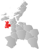 Hemne within Sør-Trøndelag | |||
| Coordinates: 63°16′16″N 9°3′21″E / 63.27111°N 9.05583°ECoordinates: 63°16′16″N 9°3′21″E / 63.27111°N 9.05583°E | |||
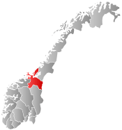
| Country | Norway | ||
| County | Sør-Trøndelag | ||
| District | Fosen | ||
| Administrative centre | Kyrksæterøra | ||
| Government | |||
| • Mayor (2007) | Ståle Vaag (Ap) | ||
| Area | |||
| • Total | 670.29 km2 (258.80 sq mi) | ||
| • Land | 635.71 km2 (245.45 sq mi) | ||
| • Water | 34.58 km2 (13.35 sq mi) | ||
| Area rank | 168 in Norway | ||
| Population (2010) | |||
| • Total | 4,207 | ||
| • Rank | 222 in Norway | ||
| • Density | 6.6/km2 (17/sq mi) | ||
| • Change (10 years) | -2.7 % | ||
| Demonym(s) | Hemnværing[1] | ||
| Time zone | CET (UTC+1) | ||
| • Summer (DST) | CEST (UTC+2) | ||
| ISO 3166 code | NO-1612 | ||
| Official language form | Neutral | ||
| Website |
www | ||
|
| |||

Hemne is a municipality in Sør-Trøndelag county, Norway. It is part of the Fosen region. The administrative centre of the municipality is the village of Kyrksæterøra. Other villages include Heim, Hellandsjøen, Holla, and Vinjeøra. The highway E39 runs through the southern part of Hemne. [2]
General information
Hemne was established as a municipality on 1 January 1838 (see formannskapsdistrikt). On 1 January 1911, the district of Heim was separated from Hemne to form a municipality of its own. This left Hemne with 3,425 residents. On 1 July 1924, Snillfjord and Vinje were separated from Hemne to form separate municipalities. After the division, Hemne had 2,030 residents remaining. Then on 1 January 1964, Vinje (population: 576) and the parts of Heim west of the Hemnfjorden (population: 711), were merged back into Hemne.[3] On 1 January 2008, the Fossdalen farm (population: 4) was transferred from Rindal (in Møre og Romsdal county) to Hemne (in Sør-Trøndelag county).[4]
Name
The name (Old Norse: Hefn) originally belonged to the Hemnfjorden. The name is derived from the word hǫfn which means "port" or "haven" (referring to the good port of Hemnskjel). Before 1918, the name was written Hevne.[5]
Coat-of-arms
The coat-of-arms is from modern times. They were granted on 14 June 1991. The arms show five yellow hazelnuts on a red background. They symbolize the relatively large hazel forests near the village, which was of economic importance for the village in previous times.[6]
Churches
The Church of Norway has three parishes (sokn) within the municipality of Hemne. It is part of the Deanery (prosti) of Orkdal and the Diocese of Nidaros.
| Parish (Sokn) | Church Name | Year Built | Location of the Church |
|---|---|---|---|
| Heim | Heim kirke | 1883 | Heim |
| Hemne | Hemne kirke | 1817 | Kyrksæterøra |
| Vinje | Vinje kirke | 1820 | Vinjeøra |
Geography
Hemne is bordered on the east by the municipalities of Snillfjord and Orkdal, on the south by Rindal and Surnadal (both in Møre og Romsdal county), and in the west by Aure and Halsa. To the north, across the waters of the Trondheimsleia lies Hitra.
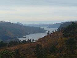
The Hemnfjorden forms the border between Hemne and Snillfjord. The Vinjefjorden is located in the southwestern side of the municipality and the lake Vasslivatnet lies in the southeast. In the south near Vinjeøra, there are several hiking trails to mountain lodges such as Sollia.
References
- ↑ "Navn på steder og personer: Innbyggjarnamn" (in Norwegian). Språkrådet. Retrieved 2015-12-01.
- ↑ Morten Haugen. "Hemne". Store norske leksikon. Retrieved October 1, 2016.
- ↑ Jukvam, Dag (1999). "Historisk oversikt over endringer i kommune- og fylkesinndelingen" (PDF) (in Norwegian). Statistisk sentralbyrå.
- ↑ Statistisk sentralbyrå (2001). "1612 Hemne. Population 1 January and population changes during the year. 1951-" (in Norwegian).
- ↑ Rygh, Oluf (1901). Norske gaardnavne: Søndre Trondhjems amt (in Norwegian) (14 ed.). Kristiania, Norge: W. C. Fabritius & sønners bogtrikkeri. p. 81.
- ↑ Norske Kommunevåpen (1990). "Nye kommunevåbener i Norden". Retrieved 25 October 2008.
External links
-
 Media related to Hemne at Wikimedia Commons
  Sør-Trøndelag travel guide from Wikivoyage
- Municipal fact sheet from Statistics Norway