Blaison-Gohier
| Blaison-Gohier | |
|---|---|
 Blaison-Gohier | |
|
Location within Pays de la Loire region  Blaison-Gohier | |
| Coordinates: 47°24′02″N 0°22′12″W / 47.4006°N 0.37°WCoordinates: 47°24′02″N 0°22′12″W / 47.4006°N 0.37°W | |
| Country | France |
| Region | Pays de la Loire |
| Department | Maine-et-Loire |
| Arrondissement | Angers |
| Canton | Les Ponts-de-Cé |
| Intercommunality | Loire Aubance |
| Government | |
| • Mayor (2008–2014) | Dominique Léon |
| Area1 | 21.45 km2 (8.28 sq mi) |
| Population (2009)2 | 1,097 |
| • Density | 51/km2 (130/sq mi) |
| Time zone | CET (UTC+1) |
| • Summer (DST) | CEST (UTC+2) |
| INSEE/Postal code | 49029 / 49320 |
| Elevation |
18–91 m (59–299 ft) (avg. 35 m or 115 ft) |
|
1 French Land Register data, which excludes lakes, ponds, glaciers > 1 km² (0.386 sq mi or 247 acres) and river estuaries. 2 Population without double counting: residents of multiple communes (e.g., students and military personnel) only counted once. | |
Blaison-Gohier is a former commune in the Maine-et-Loire department in western France. On 1 January 2016, it was merged into the new commune of Blaison-Saint-Sulpice.[1]
Population
| Historical population | ||
|---|---|---|
| Year | Pop. | ±% |
| 1793 | 1,303 | — |
| 1800 | 833 | −36.1% |
| 1806 | 994 | +19.3% |
| 1821 | 1,007 | +1.3% |
| 1831 | 1,142 | +13.4% |
| 1836 | 1,092 | −4.4% |
| 1841 | 1,086 | −0.5% |
| 1846 | 1,066 | −1.8% |
| 1851 | 1,035 | −2.9% |
| 1856 | 1,016 | −1.8% |
| 1861 | 988 | −2.8% |
| 1866 | 979 | −0.9% |
| 1872 | 998 | +1.9% |
| 1876 | 976 | −2.2% |
| 1881 | 981 | +0.5% |
| 1886 | 944 | −3.8% |
| 1891 | 928 | −1.7% |
| 1896 | 950 | +2.4% |
| 1901 | 928 | −2.3% |
| 1906 | 901 | −2.9% |
| 1911 | 862 | −4.3% |
| 1921 | 725 | −15.9% |
| 1926 | 683 | −5.8% |
| 1931 | 654 | −4.2% |
| 1936 | 661 | +1.1% |
| 1946 | 662 | +0.2% |
| 1954 | 650 | −1.8% |
| 1962 | 627 | −3.5% |
| 1968 | 555 | −11.5% |
| 1975 | 658 | +18.6% |
| 1982 | 800 | +21.6% |
| 1990 | 863 | +7.9% |
| 1999 | 951 | +10.2% |
| 2006 | 1,038 | +9.1% |
| 2009 | 1,097 | +5.7% |
-
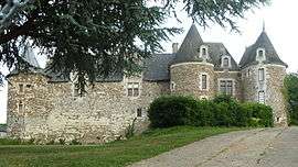
Castle of Blaison
-
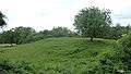
Motte-and-bailey of Blaison, before the castle
-
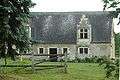
Tithe barn of Blaison
See also
References
- ↑ Arrêté préfectoral 23 November 2015
External links
| Wikimedia Commons has media related to Blaison-Gohier. |
This article is issued from Wikipedia - version of the 3/15/2016. The text is available under the Creative Commons Attribution/Share Alike but additional terms may apply for the media files.