Blaison-Saint-Sulpice
| Blaison-Saint-Sulpice | |
|---|---|
|
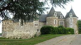
The Château of Blaison | |
 Blaison-Saint-Sulpice | |
|
Location within Pays de la Loire region  Blaison-Saint-Sulpice | |
| Coordinates: 47°24′00″N 0°22′16″W / 47.400°N 0.371°WCoordinates: 47°24′00″N 0°22′16″W / 47.400°N 0.371°W | |
| Country | France |
| Region | Pays de la Loire |
| Department | Maine-et-Loire |
| Arrondissement | Angers |
| Canton | Les Ponts-de-Cé |
| Area1 | 24.35 km2 (9.40 sq mi) |
| Population (2013)2 | 1,234 |
| • Density | 51/km2 (130/sq mi) |
| Time zone | CET (UTC+1) |
| • Summer (DST) | CEST (UTC+2) |
| INSEE/Postal code | 49029 / 49320 |
|
1 French Land Register data, which excludes lakes, ponds, glaciers > 1 km² (0.386 sq mi or 247 acres) and river estuaries. 2 Population without double counting: residents of multiple communes (e.g., students and military personnel) only counted once. | |
Blaison-Saint-Sulpice is a commune in the Maine-et-Loire department of western France. The municipality was established on 1 January 2016 and consists of the former communes of Blaison-Gohier and Saint-Sulpice.[1]
See also
References
| Wikimedia Commons has media related to Blaison-Saint-Sulpice. |
- ↑ Arrêté préfectoral 23 November 2015 (French)
This article is issued from Wikipedia - version of the 11/10/2016. The text is available under the Creative Commons Attribution/Share Alike but additional terms may apply for the media files.