Blaxland, New South Wales
| Blaxland New South Wales | |||||||||||||
|---|---|---|---|---|---|---|---|---|---|---|---|---|---|
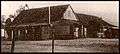
Remains_of_Pilgrim_Inn_Blaxland-1.jpg) Remains of Pilgrim Inn, c. 1825 | |||||||||||||
|
Blaxland | |||||||||||||
| Coordinates | 33°45′S 150°37′E / 33.750°S 150.617°ECoordinates: 33°45′S 150°37′E / 33.750°S 150.617°E | ||||||||||||
| Population | 7,330 (2011 census)[1] | ||||||||||||
| Established | 1830 | ||||||||||||
| Postcode(s) | 2774 | ||||||||||||
| Elevation | 234 m (768 ft) | ||||||||||||
| Location | 70 km (43 mi) west of Sydney | ||||||||||||
| LGA(s) | City of Blue Mountains | ||||||||||||
| State electorate(s) | |||||||||||||
| Federal Division(s) | Macquarie | ||||||||||||
| |||||||||||||
Blaxland is a town in the Blue Mountains of New South Wales, Australia. Blaxland is located 70 kilometres west of Sydney in the local government area of the City of Blue Mountains. It is at an altitude of 234 metres and borders the townships/suburbs of Glenbrook, Mount Riverview and Warrimoo.
History
Blaxland is named for Gregory Blaxland who along with William Lawson and William Wentworth, led the exploration that discovered a route over the Blue Mountains in 1813. Prior to 1879 the area was known as Wascoe.
The Pilgrim Inn was built c. 1825. It was a significant element in the area for some time, but eventually decayed. The remains, which are now adjacent to McDonald's, are heritage-listed.[2]
The Rev. Joshua Hargrave became a major presence in the area in the early 20th. century, and a significant force in the growth of Blaxland as a village, especially south Blaxland. He built the first church in the area and, with his family and the Calver family, is associated with four homes that still survive: Tanfield in Hope Street, Menahne in Hope Street, Rosedale in View Street and Nardi in View Street. The homes are all heritage-listed.[3]
Transport
Blaxland railway station is on the Blue Mountains Line of the NSW TrainLink intercity network. It is a disability-accessible station.
Commercial area
The village of Blaxland received a major overhaul in 2001 with the widening of the Great Western Highway. This work included the controversial planting of Canary Island Palm trees along the highway, but also created space for more shops and led to many refurbishments. These changes, combined with the upgrade of Blaxland Station, have improved business in Blaxland.
Local businesses include:
- Blue Wail Coffeehouse
- Como Restaurant, winner of a Good Food Guide Chef's Hat award for 2008.
- Supa IGA Supermarket
- Commonwealth Bank
- Subway sandwich bar
- McDonald's restaurant, the only McDonald's in the Blue Mountains
- Blaxland Day and Night Pharmacy
- The CLAY POT Cafe
- Blaxland Newsagency with Officesmart
- Brooklands Village shopping centre
Blaxland also has a small industrial estate and the only remaining land fill waste facility in the Blue Mountains.
Services
- Blue Mountains Library branch, Hope Street
- Blaxland Fire Brigade falls under the jurisdiction of the statewide Rural Fire Service
Schools
- Blaxland High School
- Blaxland East Public School
- Blaxland Public School
Sport and recreation
Blaxland includes the Florabella Pass and Pippas Pass tracks. The Lennox bridge(Lapstone Hill) and Knapsack Viaduct could be approached via Mitchell's Pass, but,do further investigation if planning to hike some or all of the way there. It is home to the Blaxland Redbacks soccer and netball teams. The Wascoe Siding Miniature Railway, on Grahame St (see map detail above), open to visitors on the 1st Sunday each month (10am to 4pm).If walking back to Blaxland station after visiting the Miniature Railway, consider taking Layton Ave. which will take you past the facilities of the service station and McDonalds.
It is also home of 1st Blaxland Scout group [4]
Gallery
-
Pilgrim Inn, c. 1920s
-
Tanfield_in_Hope_Street_Blaxland.jpg)
Tanfield, part of a heritage-listed group of homes in Hope and View Streets[1]
-
Menahne_in_Hope_Street_Blaxland.jpg)
Menahne, a heritage-listed home in Hope Street
-
Rosedale_in_View_Street_Blaxland.jpg)
Rosedale, a heritage-listed home in View Street
-
Blaxland_Presbyterian_Church-1.jpg)
Blaxland Presbyterian Church, Wilson Way
- ^ Cite error: The named reference
State_Heritage_Registerwas invoked but never defined (see the help page).
References
- ↑ Australian Bureau of Statistics (31 October 2012). "Blaxland (State Suburb)". 2011 Census QuickStats. Retrieved 17 April 2015.
- ↑ State Heritage Register
- ↑ State Heritage Register
- ↑ http://www.whitepages.com.au/wp/li/1st-blaxland-scout-group--blaxland-nsw-N13W.html
External links
![]() Media related to Blaxland, New South Wales at Wikimedia Commons
Media related to Blaxland, New South Wales at Wikimedia Commons