Blewford, Arkansas
| Blewford, Arkansas | |
|---|---|
| Ghost Town | |
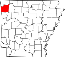
 Blewford, Arkansas Blewford' historical position in Arkansas. | |
| Coordinates: 36°10′8″N 94°19′53″W / 36.16889°N 94.33139°WCoordinates: 36°10′8″N 94°19′53″W / 36.16889°N 94.33139°W | |
| Country |
|
| State |
|
| County | Washington |
| Township | Harmon |
| Elevation[1] | 365 m (1,198 ft) |
| Time zone | Central (CST) (UTC-6) |
| • Summer (DST) | CDT (UTC-5) |
| ZIP code | 72704 |
| Area code(s) | 479 |
| GNIS feature ID | 65290 |
| U.S. Geological Survey Geographic Names Information System: Blewford, Arkansas | |
Blewford was a community in Harmon Township, Washington County, Arkansas, United States.[2] It is located inside the Ozark National Forest near Litteral Road.[3]
A post office existed from approximately 1899 to 1902.
References
- ↑ "Blewford, Arkansas". Histopolis. Retrieved 3 September 2011.
- ↑ U.S. Geological Survey Geographic Names Information System: Blewford, Arkansas United States Geological Survey. Retrieved 3 September 2011.
- ↑ Arkansas Atlas and Gazetteer (Map) (Second ed.). DeLorme. § 22.
This article is issued from Wikipedia - version of the 7/31/2013. The text is available under the Creative Commons Attribution/Share Alike but additional terms may apply for the media files.