Blindman River
| Blindman River | |
|---|---|
 | |
| Country | Canada |
| Basin | |
| Main source |
Medicine Lake Provincial Grazing Reserve 1,003 m (3,291 ft) 52°53′13″N 114°34′39″W / 52.88694°N 114.57750°W |
| River mouth |
Red Deer River 859 m (2,818 ft) 52°21′17″N 113°45′26″W / 52.35472°N 113.75722°WCoordinates: 52°21′17″N 113°45′26″W / 52.35472°N 113.75722°W |
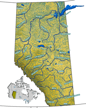
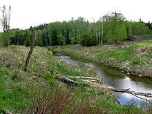
The Blindman River is a river in south-central Alberta. It forms south of Winfield, Alberta and flows southeastward before joining the Red Deer River near Red Deer. The Blindman is bridged by Alberta Highway 20 a number of times in its upper reaches, before passing near the town of Rimbey. The river then takes on the outflow of Gull Lake. It is bridged by Alberta Highway 2 at Red Deer before flowing into the Red Deer River.

There are two competing theories regarding the name of the river. One theory suggests a Cree hunting party became snowblind while traveling and had to rest on the river banks until their eyes healed. The hunting party applied the name pas-ka-poo to the river, which translates as Blindman. The second theory argues that Blindman is a descriptive term, applied to the river because of its numerous meanders and curves.[1]
The Paskapoo Formation, first described in its banks, takes its name from the Cree name for the Blindman.
Tributaries
- Anderson Creek
- Lloyd Creek
- Boyd Creek
- Potter Creek
- Gull Lake
- Anderson Creek
See also
References
- ↑ Tracey Harrison, Place Names of Alberta: Volume III, Central Alberta. (Calgary: University of Calgary Press, 1994), page 28.