Bloomfield, Montana
| Bloomfield, Montana | |
|---|---|
| Unincorporated community | |
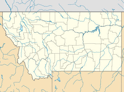 Bloomfield  Bloomfield Location of Bloomfield, Montana | |
| Coordinates: 47°24′46″N 104°55′02″W / 47.41278°N 104.91722°WCoordinates: 47°24′46″N 104°55′02″W / 47.41278°N 104.91722°W | |
| Country | United States |
| State | Montana |
| County | Dawson |
| Elevation | 2,615 ft (797 m) |
| Population (2010) | |
| • Total | 150 |
| Time zone | Mountain (MST) (UTC-7) |
| • Summer (DST) | MDT (UTC-6) |
| ZIP code | 59315 |
| Area code(s) | 406 |
| GNIS feature ID | 780133[1] |
Bloomfield (formerly, Adams[2]) is a small unincorporated community in Dawson County, Montana.[1] It is located 23 miles (37 km) northeast of the Yellowstone River and the city of Glendive, Montana, which is the county seat for Dawson County.[1] Bloomfield is inside area code 406 and has a post office with ZIP code 59315.[3] The population of the community was 150 at the 2010 United States Census.[4]
Climate
According to the Köppen Climate Classification system, Bloomfield has a semi-arid climate, abbreviated "BSk" on climate maps.[5]
References
- 1 2 3 "Bloomfield". Geographic Names Information System. United States Geological Survey.
- ↑ "Visit Montana - Bloomfield". Retrieved 6 January 2014.
- ↑ "Bloomfield, MT Zip Codes". Zip-Codes.com. Retrieved 6 January 2014.
- ↑ "American FactFinder - Community Facts". United States Census Bureau. Archived from the original on 10 December 2014. Retrieved 6 January 2014.
- ↑ Climate Summary for Bloomfield, Montana
Municipalities and communities of Dawson County, Montana, United States | ||
|---|---|---|
| City | 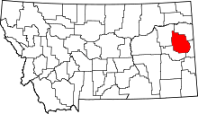 | |
| Town | ||
| CDP | ||
| Unincorporated communities | ||
This article is issued from Wikipedia - version of the 11/4/2016. The text is available under the Creative Commons Attribution/Share Alike but additional terms may apply for the media files.