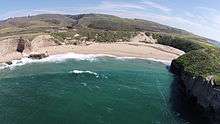
Bonny Doon, California
| Bonny Doon | |
|---|---|
| census-designated place | |
 Bonny Doon Position in California. | |
| Coordinates: 37°02′37″N 122°08′13″W / 37.04361°N 122.13694°WCoordinates: 37°02′37″N 122°08′13″W / 37.04361°N 122.13694°W | |
| Country |
|
| State |
|
| County | Santa Cruz |
| Area[1] | |
| • Total | 16.688 sq mi (43.223 km2) |
| • Land | 16.688 sq mi (43.223 km2) |
| • Water | 0 sq mi (0 km2) 0% |
| Elevation[2] | 1,476 ft (450 m) |
| Population (2010) | |
| • Total | 2,678 |
| • Density | 160/sq mi (62/km2) |
| Time zone | Pacific (PST) (UTC-8) |
| • Summer (DST) | PDT (UTC-7) |
| GNIS feature ID | 2582948 |
| U.S. Geological Survey Geographic Names Information System: Bonny Doon, California | |
Bonny Doon is a census-designated place in Santa Cruz County, California.[2] It is situated northwest of the city of Santa Cruz, considered part of the southern San Francisco Bay Area or northern Monterey Bay Area. Bonny Doon's population was 2,678, as reported by the 2010 United States Census.
It was founded in the 1850s as a logging camp. The current name can be attested back to 1902:[3] John Burns, a Scotsman living in Santa Cruz, named Bonny Doon after a line in the Robert Burns' song "The Banks O' Doon". The line is: "Ye banks and braes o' bonnie Doon...", and refers back to the Doon River in Scotland. Evidence of 2,600 years of occupation by Native Americans has been found in the area.
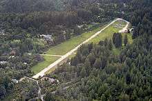
Bonny Doon has no city center or commercial shops, but features several wineries, a church, two fire stations, a lavender farm, an ecological reserve, an elementary school, and a private-use airport. A beach of the same name is nearby.
Geography
According to the United States Census Bureau, the CDP covers an area of 16.7 square miles (43.2 km²), all of it land. The area sits at an elevation of 1,476 feet (450 m).[2]
Description
The area is on a slope with higher elevations in redwood forest or maritime chaparral, and lower elevations descending into the coastal zone, which is occupied by grasslands. There are ocean views from parts of the area on days when fog is not present. The University of California, Santa Cruz is close to the area, just down Empire Grade, so Bonny Doon is popular with people who work there or those who work from home and telecommute. Even though it is an outlying area, DSL, Cable Modem and television service are available; mobile phone service, however, is very limited due to the mountainous terrain and myriad trees.
Notable sites
Robert A. Heinlein (1907–1988), a noted science fiction author, and his wife Virginia, resided in Bonny Doon from 1965 until just before his death. They designed and built the house themselves.[4]
The road to Bonny Doon from State Route 1, aptly named Bonny Doon Road, crosses an enclosed, unmarked conveyor belt, which carried limestone from a quarry 3 miles (4.8 km) east to the Cemex cement plant in Davenport. The Davenport plant had supplied cement for later stages of the Panama Canal and other large projects since its founding in 1906, but is now closed.
Demographics
The 2010 United States Census[5] reported that Bonny Doon had a population of 2,678. The population density was 160.5 people per square mile (62.0/km²). The Census reported that 99.0% of the population lived in households and 1.0% lived in non-institutionalized group quarters. The average household size was 2.44.
There were 1,218 housing units at an average density of 73.0 per square mile (28.2/km²), of which 73.3% were owner-occupied and 26.7% were occupied by renters. The homeowner vacancy rate was 1.2%; the rental vacancy rate was 4.9%. 75.7% of the population lived in owner-occupied housing units and 23.3% lived in rental housing units.
There were 1,088 households, out of which 268 (24.6%) had children under the age of 18 living in them, 579 (53.2%) were opposite-sex married couples living together, 59 (5.4%) had a female householder with no husband present, 49 (4.5%) had a male householder with no wife present. There were 76 (7.0%) unmarried opposite-sex partnerships, and 17 (1.6%) same-sex married couples or partnerships. 264 households (24.3%) were made up of individuals and 79 (7.3%) had someone living alone who was 65 years of age or older. There were 687 families (63.1% of all households); the average family size was 2.77.
The racial makeup of Bonny Doon was 2,474 (92.4%) White, 9 (0.3%) African American, 15 (0.6%) Native American, 51 (1.9%) Asian, 5 (0.2%) Pacific Islander, 48 (1.8%) from other races, and 76 (2.8%) from two or more races. Hispanic or Latino of any race were 168 persons (6.3%).
The age of the population was spread out, with 447 people (16.7%) under the age of 18, 210 people (7.8%) aged 18 to 24, 579 people (21.6%) aged 25 to 44, 1,082 people (40.4%) aged 45 to 64, and 360 people (13.4%) who were 65 years of age or older. The median age was 47.5 years.
There were more males than females. For every 100 females there were 110.7 males. For every 100 females age 18 and over, there were 112.9 males.
News
1979 murder of Maureen Minton
In the mid-seventies, Ron Huffman and Maureen Minton, alleged marijuana growers, carried out a number of New World Liberation Front bombings. On September 23, 1979, Huffman murdered Minton with an axe. He fled his home in Bonny Doon with $32,000 in cash, bags of marijuana and part of Minton's brain. Police caught Ron Huffman in Pacifica and he was arrested.
2008 and 2009 wildfires
At 2:54 p.m. on June 11, 2008, a fire broke out at the Bonny Doon Ecological Reserve, a preserve with a number of hiking trails located on Martin Road. This Martin Fire burned 520 acres (2.1 km2), destroying three residences and eight outbuildings. About 1,500 residents of Bonny Doon were evacuated as a result of the fire. Governor Arnold Schwarzenegger declared a state of emergency for Santa Cruz County. The blaze cost over $5.4 million to contain and was part of a busy summer of wildfires in California.[6]
Little more than one year later, on August 12, 2009 at 7:16 pm, a second fire started in Bonny Doon, near the Lockheed facility off Empire Grade. The Lockheed Fire burned 7,817 acres (31.63 km2), and destroyed 13 outbuildings. More than 2,000 residents were evacuated as the blaze spread from Swanton south toward Bonny Doon. The blaze cost over $26.6 million and took nearly 2 weeks to be fully contained. The cause of the fire remains under investigation.[7]
2009 murder of Jasmine Fiore
Bonny Doon was briefly in the spotlight in 2009 when model Jasmine Fiore was murdered. Jasmine grew up in Bonny Doon and attended the local elementary, where she was known as Jasmine Lepore.
References
- ↑ U.S. Census Archived 2012-01-24 at WebCite
- 1 2 3 U.S. Geological Survey Geographic Names Information System: Bonny Doon, California
- ↑ Gudde, Erwin G. (1998). California place names : the origin and etymology of current geographical names (4th ed., rev. and enl. ed.). Berkeley: University of California Press. p. 42. ISBN 0520213165.
- ↑ The Heinleins' unique circular house can be seen on Google Maps on the east side of Bonny Doon Road, just south of where Shake Mill Road dead-ends into Bonny Doon Road from the west.
- ↑ "2010 Census Interactive Population Search: CA - Bonny Doon CDP". U.S. Census Bureau. Retrieved July 12, 2014.
- ↑ http://cdfdata.fire.ca.gov/incidents/incidents_details_info?incident_id=273
- ↑ http://cdfdata.fire.ca.gov/incidents/incidents_details_info?incident_id=361
External links
- http://www.bonny-doon.info
- Rural Bonny Doon Association
- Bonny Doon Elementary School site
- Bonny Doon Weather Page
Municipalities and communities of Santa Cruz County, California, United States | ||
|---|---|---|
| Cities |  | |
| CDPs | ||
| Unincorporated communities | ||
| Ghost town | ||