Bransfield Strait
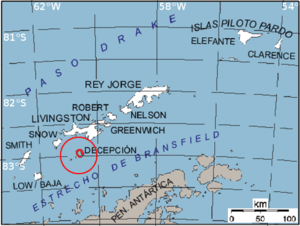
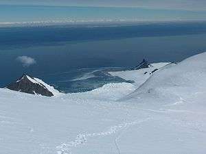
Bransfield Strait is a body of water about 100 kilometres (60 mi) wide extending for 300 miles (500 km) in a general north-east - south-west direction between the South Shetland Islands and the Antarctic Peninsula.
History
The strait was named in about 1825 by James Weddell, Master, Royal Navy, for Edward Bransfield, Master, RN, who charted the South Shetland Islands in 1820. It is called Mar de la Flota by Argentina. On 23 November 2007, the MS Explorer struck an iceberg and sank in the strait; all 154 passengers were rescued and no injuries were reported.
Description
The undersea trough through the strait is known as Bransfield Trough (61°30′S 54°0′W / 61.500°S 54.000°W). The basin is about 400 km long and 2 km deep, between the South Shetland Island Arc and the Antarctic Peninsula. It was formed by rifting behind the islands, which began about 4 million years ago.[1] Ongoing rifting has caused recent earthquakes and volcanism. The Strait hosts a chain of submerged seamounts of volcanic origin, including the presently inactive Orca Seamount.[2]
Antarctic Specially Protected Area
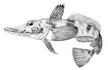
An area of relatively shallow marine waters of about 1021 km2, off the western and southern coasts of Low Island, has been designated an Antarctic Specially Protected Area (ASPA 152) because it is one of only two known sites near the United States’s Palmer Station suitable for bottom trawling for fish and other benthic organisms. Fish have been collected from the site by scientists from Palmer Station since the early 1970s, and it is recognised as an important spawning ground for several species, including Black Rockcod and Blackfin Icefish.[3]
See also
References
- ↑ Yi, S., Batten, D. J., Lee, S. J. (21 Nov 2005). Provenance of recycled palynomorph assemblages recovered from surficial glaciomarine sediments in Bransfield Strait, offshore Antarctic Peninsula. Cretaceous Research, 26, 906-919
- ↑ Hatzky, Jörn (2005): The Orca Seamount Region, Antarctica (Sect. 5.5.2). In: Peter C. Wille (ed.), Sound Images of the Ocean in Research and Monitoring, Springer-Verlag Berlin.
- ↑ "Western Bransfield Strait" (PDF). Management Plan for Antarctic Specially Protected Area No. 149: Measure 10, Annex. Antarctic Treaty Secretariat. 2009. Retrieved 2013-10-02.
-
 This article incorporates public domain material from the United States Geological Survey document "Bransfield Strait" (content from the Geographic Names Information System).
External links
| Wikimedia Commons has media related to Bransfield Strait. |
| General | .svg.png) | |
|---|---|---|
| Geographic regions | ||
| Waterways | ||
| Famous explorers | ||
Coordinates: 63°S 59°W / 63°S 59°W