Clarence Island (South Shetland Islands)
 Location of Clarence Island | |
 Clarence Island | |
| Geography | |
|---|---|
| Location | Antarctica |
| Coordinates | 61°12′S 054°05′W / 61.200°S 54.083°WCoordinates: 61°12′S 054°05′W / 61.200°S 54.083°W |
| Archipelago | South Shetland Islands |
| Length | 21.46 km (13.335 mi) |
| Highest elevation | 1,950 m (6,400 ft) |
| Highest point | Mount Irving |
| Administration | |
|
None | |
| Demographics | |
| Population | 0 |
| Additional information | |
| Administered under the Antarctic Treaty System | |
.jpg)
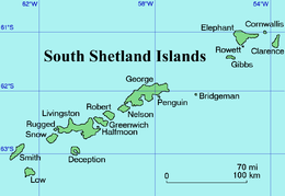
Clarence Island is 21.46 km (13.3 mi) long in south-southwest to north-northeast direction and the easternmost of the South Shetland Islands of Antarctica. The name dates back to at least 1821 and is now established in international usage. Ernest Shackleton saw Clarence Island on his famous boat voyage but landed on Elephant Island. It is claimed by Argentina as part of Argentine Antarctica, by Britain as part of the British Antarctic Territory, and by Chile as part of the Chilean Antarctic Territory.
Ravelin Ridge and Urda Ridge occupy the interior of the mountainous island. The summit Mount Irving, 1,950 meters (6,398 ft) high,[1][2] rises 6.675 km (4.148 mi) north of Cape Bowles, the southernmost point. The southeast slopes of the two ridges are drained by Dobrodan, Highton, Treskavets, Orcho and Banari Glaciers, and their northwest slopes — by Skaplizo, Giridava and Bersame Glaciers. There are two small islands just east of Clarence Island, the northern one is named Sugarloaf Island. Chinstrap Cove lies on the northwest coast of the island, while Istros Bay, Smith Cove and Kutela Cove lie on its southeast side.
See also
- Composite Antarctic Gazetteer
- List of Antarctic islands south of 60° S
- SCAR
- Territorial claims in Antarctica
Notes
- ↑ South Shetland Islands: Elephant, Clarence and Gibbs Islands. Archived December 9, 2014, at the Wayback Machine. Scale 1:220000 topographic map. UK Antarctic Place-names Committee, 2009.
- ↑ Mount Irving. British Antarctic Territory Gazetteer. UK-APC.