Brantingham Lake
| Brantingham Lake | |
|---|---|
| Jewel of the Adirondack | |
 | |
| Coordinates | 43°41′50″N 75°18′45″W / 43.69722°N 75.31250°WCoordinates: 43°41′50″N 75°18′45″W / 43.69722°N 75.31250°W |
| Surface area | 327 acres (1.32 km2) |
| Max. depth | 70 ft. |
| Islands | 2 (Round)(Dark) |
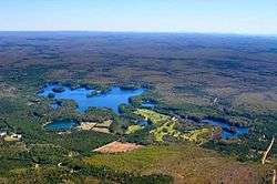
Brantingham Lake is a 327 acres (1.32 km2) lake, within the Adirondack Park, located east of the hamlet Brantingham in Lewis County, New York. Home to both seasonal and year round residents, the lake and surrounding area offer public boating, fishing, hunting, hiking, biking, ATV, horse, and snowmobile trails, the Brantingham Golf Club, and a variety of restaurants including the Pine Tree Tavern, Brantingham Inn Motel, Trailside Inn, Brantingham General Store and Coach Light Inn. During the winter months, the area receives an average 150 inches of snow, making Brantingham a popular destination for winter enthusiasts.[1]
History
Oneida Indians, who called the lake "Fish Lake", ceded most of the land in and around Brantingham to the state of New York by formal treaty on February 22, 1788.
In 1793, Alexander Macomb made an application to purchase more than 3,500,000 acres (14,000 km2) of land at six cents an acre, including all of Lewis County. On April 4, 1794, the land was sold to Thomas Hopper Brantingham of Philadelphia for $23,073, (forty-six cents an acre), however soon after, he executed three mortgages on the land, neglecting to make good on his debts, eventually it was sold again.
John Greig became the next to acquire the land on which Brantingham sits. The town name eventually was changed to Greig, due to the past negative perception of Thomas Hooper Brantingham. Even with this change, the lake and surrounding hamlet kept the name Brantingham.
Geography
Brantingham Lake covers 341 acres (1.38 km2) with eleven miles (18 km) of shoreline. The lake has a maximum depth of 70 feet, and an average depth of 30 feet in accordance with fluctuating yearly water levels. There are two islands present, Grant, or Round Island, and Dark Island, in the north, northwest region. Two distinct sand bars, each one marked by buoys and one visibly submerged sand bar stemming off of Dark Island are visible. Depending on yearly water levels, these shallow sand bars may only be covered by a few feet of water, requiring caution from boaters. The lake bottom yields little vegetation, but rather is covered by organic matter and sand, making the lake favorable for recreational use during the summer months.
On the southwestern side of the lake, a stone bridge crosses an inlet leading to the portion of the lake that is referred to as the "Lily Pond" and near the farthest end of it to the west of the base of "Shady Point" is a small dam used to draw down lake levels from October to May in order to prevent shore erosion and damage to docks during the winter. The water traveling over that dam flows south to the Lake of the Pines.
A variety of fish are present in the lake such as Blue Gill, northern pike, Brown Bullhead, Lake Whitefish, Largemouth Bass, Pumpkinseed Sunfish, Rock Bass, White Sucker, and Yellow Perch.
In 1995 a brief severe weather phenomenon, a microburst, caused heavy damage to lake properties and the surrounding landscape.[2]
Surrounding Locations
- Catspaw Lake – A small lake (beaver pond) north of Brantingham with an abundance of small pickerel
- Glenfield – A hamlet west of Brantingham, at the Black River
- Greig – A town bordering the southwestern part of Brantingham
- Otter Creek – A creek and a hamlet of the same name, north of Greig
Images
-
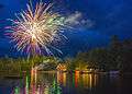
4th of July fireworks
-

Lily Pond Foot Bridge on Brantingham Lake, NY
-
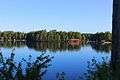
Dark Island in the Distance
-

Dusk sky over Brantingham Lake
-

Morning Mist on the Lake
-
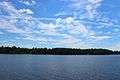
Summer sky over Brantingham Lake
References
- ↑ Lewis County Weather. "Lewis County Weather, USA.com. Retrieved on 2 January 2015.
- ↑ National Weather Service Albany NY. "Adirondack Derecho of July 1995, National Weather Service Albany NY, Albany, NY, 15 July 2005. Retrieved on 2 January 2015.
External links
Municipalities and communities of Lewis County, New York, United States | ||
|---|---|---|
| Towns | 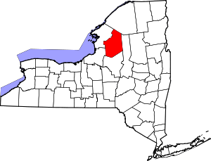 | |
| Villages | ||
| Other hamlets | ||