Croghan (town), New York
| Croghan | |
|---|---|
| Town | |
|
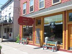
Good Ol' Wishy's, a typical storefront | |
 Croghan Location within the state of New York | |
| Coordinates: 43°58′13″N 75°21′24″W / 43.97028°N 75.35667°WCoordinates: 43°58′13″N 75°21′24″W / 43.97028°N 75.35667°W | |
| Country | United States |
| State | New York |
| County | Lewis |
| Area | |
| • Total | 182.1 sq mi (472 km2) |
| • Land | 179.4 sq mi (465 km2) |
| • Water | 2.7 sq mi (7 km2) |
| Elevation[1] | 994 ft (303 m) |
| Population (2010)[2] | |
| • Total | 3,093 |
| • Density | 17/sq mi (6.6/km2) |
| Time zone | Eastern (EST) (UTC-5) |
| • Summer (DST) | EDT (UTC-4) |
| ZIP codes | 13327, 13619, 13665, 13620, 13367[3] |
| Area code(s) | 315 |
| GNIS feature ID | 978878[1] |
| Website |
www |
Croghan is a town in Lewis County, New York, United States. The population was 3,093 at the 2010 census.[2]
The Town of Croghan is in the northern part of the county and located northeast of the county seat, Lowville. The town contains a village also named Croghan, a small part of which is located in the town of New Bremen. Both the village and town are locally pronounced \Krō-gun\ (with a hard g and silent h, emphasis on the first syllable).
History
The southwest part of the town was the locale of an ill-fated colony of refugees from the French Revolution. The settlements were disbanded by 1814. Modern settlement began around 1830.
The town was formed in 1848 from the Towns of Watson and Diana. In 1848, part of the town was used to help form New Bremen.
Theodore B. Basselin played a large part in Croghan’s history. Mr. Basselin came to America and settled in Croghan where he became the town’s first millionaire due to his successful logging business. He was one of the town’s top employers in his day. The beautiful Basselin mansion still stands in downtown Croghan. Mr. Basselin is responsible for a few other landmarks in the town. The Croghan Library that was once the Basselin Opera House stands down the road from the Basselin Mansion. Also next to the library is the Basselin Cemetery. The American Maple Museum, which is located next to St. Stephen’s church, was originally the Father Leo Memorial School. The school was built from the funds of the Basselin estate.[4]
The Croghan Island Mill was listed on the National Register of Historic Places in 2010.[5]
1912 fire
The second great Croghan fire occurred on May 1, 1912. The fire caused considerable damage to the downtown business district of the village. Thirty-Two buildings were destroyed by the flames with the total damage estimated to have been about $600,000. Two children, who lived in the building where the fire started, lost their lives. The fire was so large that assistance had to be provided by the Lowville Fire Department, who sent a train into town with supplies and men.
The fire had its origin in a back yard bonfire which accidentally made its way into the Grounert Café building where two children of the family were trapped in the smoke filled building. The children were eventually rescued from the blaze but both died almost immediately afterwards.
The firefighters who were excited by the rescue, underestimated the danger of the fire to spread to nearby structures. Most of the buildings at the time were wooden structures which allowed the fire to spread quickly from building to building. The spreading happened so quickly that firefighters were driven from the hydrants so quickly that they, at times did not have time to shut them off. This weakened the water pressure significantly which later handicapped the effort to stop the blaze.
The fire had crossed the street setting both sides ablaze. Thirty-two buildings were destroyed, including the post office, a general store, Peter Shinbourne’s Shoe factory, William Ritz’s Café, Raymond Lee’s five and ten cent store, Norman Martin’s hotel and many people’s homes. On the other side of the street, Monett’s store, many more homes, the Town Hall, Honsicker’s Meat Market, S.E. Simon’s Drug Store, and Marilley’s General Store were also destroyed. Marilley’s Store alone lost an estimated $50,000 in damages. The Town Hall and Opera House both of which had been recently remodeled a large expense.
The local fire department realized that they needed assistance and made a call for help to Lowville. A train was sent with a chemical engine, 1,500 feet of hose and a company of fifteen firemen. Much of the hose was lost because it could not be disconnected from the hydrants in time. The Farney & Steiner and Virkler feed and grist mills were destroyed along with much value machinery, one of the mill owners lost about $200,000.
The fire was eventually stopped after firefighters concentrated their efforts. The fire ended just short of St. Stephen's Roman Catholic Church. The Franciscan monastery with the large school building connected with it was also saved. On the opposite side of the street the blaze stopped at the Basselin Mansion, both of which still stand there today.[6]
Geography
According to the United States Census Bureau, the town has a total area of 182.1 square miles (471.5 km²), of which 179.4 square miles (464.7 km²) is land and 2.7 square miles (6.9 km²) (1.46%) is water.
The west town line is partly the border of Jefferson County, and the east town line is the border of Herkimer County.
The Black River defines the west town line. The Indian River flows out from the northwest part of the town. The Beaver River flows through the south part of Croghan.
New York State Route 812 is a north-south highway in the town. NY-812 intersects New York State Route 126 at the south town line. NY-126 intersects east-west highway New York State Route 410 by the west town line.
Demographics
| Historical population | |||
|---|---|---|---|
| Census | Pop. | %± | |
| 1850 | 1,135 | — | |
| 1860 | 2,035 | 79.3% | |
| 1870 | 2,433 | 19.6% | |
| 1880 | 3,374 | 38.7% | |
| 1890 | 3,527 | 4.5% | |
| 1900 | 3,159 | −10.4% | |
| 1910 | 2,807 | −11.1% | |
| 1920 | 2,551 | −9.1% | |
| 1930 | 2,392 | −6.2% | |
| 1940 | 2,557 | 6.9% | |
| 1950 | 2,544 | −0.5% | |
| 1960 | 2,697 | 6.0% | |
| 1970 | 2,559 | −5.1% | |
| 1980 | 2,824 | 10.4% | |
| 1990 | 3,071 | 8.7% | |
| 2000 | 3,162 | 3.0% | |
| 2010 | 3,093 | −2.2% | |
| Est. 2014 | 3,126 | [7] | 1.1% |
As of the census[9] of 2000, there were 3,161 people, 1,115 households, and 855 families residing in the town. The population density was 17.6 people per square mile (6.8/km²). There were 1,664 housing units at an average density of 9.3 per square mile (3.6/km²). The racial makeup of the town was 99.24% White, 0.13% Black or African American, 0.06% Native American, 0.06% Asian, 0.22% from other races, and 0.28% from two or more races. Hispanic or Latino of any race were 0.47% of the population.
There were 1,115 households out of which 37.9% had children under the age of 18 living with them, 64.0% were married couples living together, 7.3% had a female householder with no husband present, and 23.3% were non-families. 18.7% of all households were made up of individuals and 9.7% had someone living alone who was 65 years of age or older. The average household size was 2.83 and the average family size was 3.25.
In the town the population was spread out with 28.7% under the age of 18, 8.4% from 18 to 24, 28.3% from 25 to 44, 22.9% from 45 to 64, and 11.7% who were 65 years of age or older. The median age was 36 years. For every 100 females there were 102.0 males. For every 100 females age 18 and over, there were 100.5 males.
The median income for a household in the town was $34,722, and the median income for a family was $39,267. Males had a median income of $28,712 versus $19,423 for females. The per capita income for the town was $13,408. About 9.0% of families and 12.1% of the population were below the poverty line, including 13.9% of those under age 18 and 15.5% of those age 65 or over.
Communities and locations in the Town of Croghan
- Beaver Falls —- A hamlet west of Croghan village.
- Beaver Falls Airport this was an emergency landing only hasn't been used in years—An airport west of Beaver Falls.
- Belfort —- A hamlet northeast of Croghan village, colloquially known as "The City of the Future".
- Bishas Mill – A location on the east town line east of Jerden Falls. Both are now only cellar holes
- Croghan — The Village of Croghan is at the south town line on NY-812 and the Beaver River.
- Dutton Corners – A location in the north part of the town, northwest of Jerden Falls.
- Forest City – A hamlet northwest of Croghan village.
- High Falls —- A hamlet northeast of Croghan village.
- Indian River — A hamlet north of Croghan village on NY-812.
- Jerden Falls – A location in the north part of the town. Once had a large tannery and associated hamlet.
- Karter Crossing – A location on the west town line near north Croghan Crossing.
- NaumburgAnd the subdivision Snipe Island (earlier, "Prussian Settlement") —- A hamlet at the junction of Routes NY-126 and NY-410 at the southwest corner of the town near the Black River.
- North Croghan – A hamlet in Jefferson County, west of North Croghan Crossing.
- North Croghan Crossing – A location at the west town line.
- Soft Maple —- A hamlet near the east town line. Consists of camps and a powerplant and a defunct gold mine.
- Texas – A hamlet in the northwest part of the town.
References
- 1 2 U.S. Geological Survey Geographic Names Information System: Croghan (town), New York
- 1 2 "American FactFinder". U.S. Census Bureau. Archived from the original on September 11, 2013. Retrieved December 14, 2012.
- ↑ "NYS Orthos Online". NYS GIS Clearinghouse. Retrieved December 14, 2012.
- ↑ http://www.adirondackstughill.com/croghan.php
- ↑ "National Register of Historic Places". National Register of Historic Places. National Park Service. 2010-08-06.
- ↑ http://www3.gendisasters.com/new-york/2436/croghan%2C-ny-fire%2C-apr-1912?page=0%2C1
- ↑ "Annual Estimates of the Resident Population for Incorporated Places: April 1, 2010 to July 1, 2014". Retrieved June 4, 2015.
- ↑ "Census of Population and Housing". Census.gov. Archived from the original on May 11, 2015. Retrieved June 4, 2015.
- ↑ "American FactFinder". United States Census Bureau. Archived from the original on September 11, 2013. Retrieved 2008-01-31.
External links
Municipalities and communities of Lewis County, New York, United States | ||
|---|---|---|
| Towns | 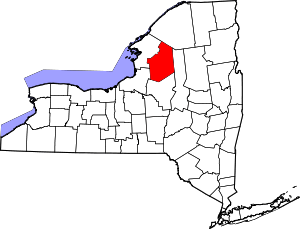 | |
| Villages | ||
| Other hamlets | ||