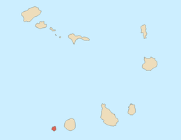
Brava, Cape Verde
| Native name: <span class="nickname" ">Dja Braba Nickname: Ilha das flores (island of the flowers) | |
|---|---|
 | |
 | |
| Geography | |
| Location | Atlantic Ocean |
| Coordinates | 14°52′N 24°42′W / 14.867°N 24.700°W |
| Area | 67 km2 (26 sq mi) |
| Length | 24 km (14.9 mi) |
| Width | 16 km (9.9 mi) |
| Highest elevation | 976 m (3,202 ft) |
| Highest point | Monte Fontainhas |
| Administration | |
|
Cape Verde | |
| Concelhos (Municipalities) | Brava |
| Largest settlement | Nova Sintra |
| Demographics | |
| Population | 5971 (2010) |
| Pop. density | 89.1 /km2 (230.8 /sq mi) |
Brava (Portuguese for “wild”) is an island in Cape Verde. It is the smallest inhabited island, but at the same time the greenest, of Cape Verde, in the Sotavento group. First settled in the 1540s, its population grew after Mount Fogo on neighbouring Fogo erupted in 1675. Its main industry was long whaling, but the island is now primarily agricultural.
History
Brava was discovered in 1462 by the Portuguese and the first settlement was founded in 1573. The slave trade was common in Cidade Velha. Sir Francis Drake visited the island in 1579 In 1680, the inhabitants fled from the nearby larger island of Fogo after its volcano erupted and lava began to flow and devastate that island. In the 17th and the 18th centuries, pirates raided the bays of the island and continued until the 19th century when whaling was common from the ships of Europe and North America.
Emigration began as US whaleships sailed people from Brava to the northeastern part of North America, especially along the Eastern Seaboard. Most of the immigrants from Brava settled in Boston, Massachusetts, Providence, Rhode Island and New Bedford, Massachusetts.
Geography
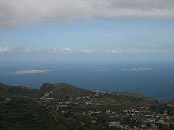
Practically the whole island is a stratovolcano. It lies in the lee of the enormous Fogo volcano. Volcanic activity on the island has been mainly located along three lines, which all intersect at the crest of ground that forms the highest part of the island. Brava has no documented historical eruptions, but its youthful volcanic morphology and the fact that earthquake swarms still occur indicate the potential for future eruptions.
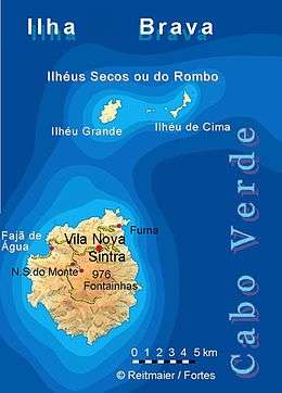
North of Brava are two small islands with 4 islets, 3 of them are west of Ilhéu de Cima. The islands are Ilhéu Grande.
The island's main town is Vila Nova Sintra. The island has elementary and secondary schools, churches, and a square (praça) in honour of the famous musician Eugénio Tavares.
All of the five villages lie north of the mountaintop, which has four main roads including Furna - Vila Nova Sintra and Fajã de Agua and south to Nossa Senhora do Monte and slightly south of the mountaintop. The two large islands north of Brava are uninhabited. The mountain valleys dominate the south, the east and the west. The north has a few valleys.
Precipitation arrives from the trade wind clouds. The island is covered with a leeward cloud so that evaporation is reduced and the vegetation is more abundant. Key inhabited places include the village of Vila Nova Sintra. The village of Furna has a commercial port.
Climate
Being highly mountainous this island has quite diverse climate. Brava island has moderate tropical climate (As according to Köppen–Geiger climate classification system) along the coast and semi-arid mild tropical climate Bsh with very balanced temperatures year round in the interior. The average annual temperature on the coast is about 23–25 °C (73–77 °F), decreasing to some 17–20 °C (63–68 °F) in the mountains. There can be remarkably cool weather with warmer wet season starting in June and ending in November with colder dry season starting in December and ending in May.
| Climate data for Cachaço, south of Nova Sitra, 800 metres ASL | |||||||||||||
|---|---|---|---|---|---|---|---|---|---|---|---|---|---|
| Month | Jan | Feb | Mar | Apr | May | Jun | Jul | Aug | Sep | Oct | Nov | Dec | Year |
| Average high °C (°F) | 18.7 (65.7) |
18.6 (65.5) |
19.4 (66.9) |
19.8 (67.6) |
20.4 (68.7) |
21.0 (69.8) |
22.2 (72) |
23.1 (73.6) |
23.3 (73.9) |
22.6 (72.7) |
21.7 (71.1) |
19.6 (67.3) |
20.9 (69.6) |
| Daily mean °C (°F) | 16.2 (61.2) |
16.1 (61) |
16.6 (61.9) |
16.9 (62.4) |
17.6 (63.7) |
18.4 (65.1) |
19.4 (66.9) |
20.5 (68.9) |
20.8 (69.4) |
20.4 (68.7) |
19.1 (66.4) |
17.4 (63.3) |
18.3 (64.9) |
| Average low °C (°F) | 13.8 (56.8) |
13.6 (56.5) |
13.8 (56.8) |
14.1 (57.4) |
14.9 (58.8) |
15.8 (60.4) |
16.7 (62.1) |
17.9 (64.2) |
18.4 (65.1) |
18.2 (64.8) |
16.5 (61.7) |
15.2 (59.4) |
16.9 (62.4) |
| Average rainfall mm (inches) | 11 (0.43) |
5 (0.2) |
1 (0.04) |
0 (0) |
0 (0) |
0 (0) |
17 (0.67) |
83 (3.27) |
123 (4.84) |
53 (2.09) |
33 (1.3) |
20 (0.79) |
346 (13.63) |
| Source: climate-data.org[1] | |||||||||||||
Demographics
Population
As of 1832, the population was estimated at 8,000.[2]
| Population of Brava, Cape Verde (1940—2010) | |||||||
|---|---|---|---|---|---|---|---|
| 1940[3] | 1950[3] | 1960[3] | 1970[3] | 1980[3] | 1990[3] | 2000[4] | 2010[5] |
| 8528 | 7937 | 8625 | 7756 | 6985 | 6975 | 6804 | 5971 |
Economy
The main economy of the island is agricultural, related to irrigation and fishing (the island's main production). Trading and private households depend on income from Cape Verdean residents from North America. Brava never had a lot of tourism. Tourism slowly boomed. The island is unsuitable for beach tourism because the steep shoreline allows few beaches.
Attractions and amenities
- Nova Sintra, a town with a museum, traditional Portuguese architecture, several churches and shops.
- Fajã de Agua, a small harbour on the West coast with a natural swimming pool.
- Nossa Senhora do Monte, a village in the mountains with a pilgrimage church.
- Cova Rodela, a village in the mountains with a dragon tree in its main street.
Sporting teams
- Académica
- Benfica
- Corôa
- Juventude da Furna - the newest club on the island
- Morabeza
- No Pintcha
- Sporting
Infrastructure

The airport, inaugurated in 1992, was closed because of the strong winds. The airline service ended in 2004.
Until recently, there was a daily ferry (an ex-fishing boat) connecting Brava and Fogo. However, since January 2011, Brava can now be reached from Praia (and Fogo) almost exclusively via the passenger/cargo ferry, the Kriola. The Kriola is the first of Cabo Verde Fast Ferry's fleet of inter-island catamarans and connects the Sotavento islands of Santiago, Fogo, and Brava. The Kriola typically leaves Furna, its home port, at 7:30 AM on days of operation and returns between 9:30 and 11 PM, depending on the day. The route is typically BRAVA-FOGO-SANTIAGO-FOGO-BRAVA, but at least one day a week it makes a BRAVA-FOGO-BRAVA run. Travel time between Brava and Fogo is approximately 0:40 and approximately 3:30 between Fogo and Santiago (Praia).
The main harbour of Brava is Furna, on the east coast of the island. Buses and taxis are common, especially when the Kriola arrives in port.
On Brava you can reach the villages by "Aluguer" bus. There is no fixed schedule, as the aluguers wait until enough passengers have come before leaving. A few taxis are available as well.
Notable residents
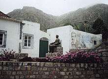
Brava's most famous son is the musician Eugénio Tavares; he used the traditional morna and wrote in Cape Verdean Creole. A statue dedicated to Eugénio Tavares is in the main square of Vila Nova Sintra, surrounded by a garden with trees, sunflowers, flowers, grass and other types of plants. Other notable persons include Hermano da Pina and Armando da Pina who live on the Eastern Seaboard and whose parents were from Brava, and Sandra Orlando (née Fernandez das Neves).
- Eugénio Tavares – writer and composer
- Vinny deMacedo - Massachusetts State Representative & State Senate Candidate was born in Brava
References
- ↑ Climate-Data.org http://en.climate-data.org/location/789800/. Retrieved 28 December 2013. Missing or empty
|title=(help) - ↑ Roberts, Edmund (1837). Embassy to the Eastern Courts of Cochin-China, Siam, and Muscat. New York: Harper & Brothers. p. 17.
- 1 2 3 4 5 6 Source: Statoids
- ↑ Source: Instituto Nacional de Estatísticas.
- ↑ Portal do Instituto Nacional de Estatística: INE - CENSO 2010.
External links
| Wikimedia Commons has media related to Brava (Cape Verde). |
- Brava News - News directly from Brava
- Brava island - caboverde.com
- Brava, Cape Verde Islands - University of Massachusetts
| Island groups | ||
|---|---|---|
| Islands | ||
| Islets | ||