Brockway, Montana
| Brockway, Montana | |
|---|---|
| Unincorporated community | |
 Brockway, Montana Location within the state of Montana | |
| Coordinates: 47°17′59″N 105°45′47″W / 47.29972°N 105.76306°WCoordinates: 47°17′59″N 105°45′47″W / 47.29972°N 105.76306°W | |
| Country | United States |
| State | Montana |
| County | McCone |
| Population (2000) | |
| • Total | 140 |
| Time zone | Mountain (MST) (UTC-7) |
| • Summer (DST) | MDT (UTC-6) |
Brockway is an unincorporated community in southern McCone County, Montana, United States located near the Redwater River. At the 2000 census,[1] the Brockway area had a population of approximately 140 people.[2] Brockway is located near the junction of Montana Highway 200 and Montana Secondary Highway 253 along the recently designated Big Sky Back Country Byway,[3][4] approximately 10 miles southwest of Circle, Montana. Brockway is home to the annual Brockway Dairy Day Rodeo.
History
The town "became a major livestock shipping point reaching number one in the U.S. in 1934," according to historical marker author Bob Fletcher.[5]
Climate
According to the Köppen Climate Classification system, Brockway has a semi-arid climate, abbreviated "BSk" on climate maps.[6]
References
- ↑ "American FactFinder". United States Census Bureau. Archived from the original on 2013-09-11. Retrieved 2008-01-31.
- ↑ Covers Census Tract 9540, Blocks 1023, 1033-1059, and 1071, See U.S. Census Table.
- ↑ "Big Sky Back Country Byway". Federal Highway Administration, United States Department of Transportation. Retrieved 2007-01-30.
- ↑ "Big Sky Back Country Byway". Travel Montana, State of Montana. Retrieved 2007-01-30.
- ↑ Wilson, Kurt (2014-11-02). "Roadside Wanderings: Resilient northeastern Montana". Missoulian. Retrieved 2014-11-02.
- ↑ Climate Summary for Brockway, Montana
External links
Municipalities and communities of McCone County, Montana, United States | ||
|---|---|---|
| Town | 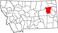 | |
| Unincorporated communities | ||