Brush Fork, West Virginia
| Brush Fork, West Virginia | |
|---|---|
| Census-designated place (CDP) | |
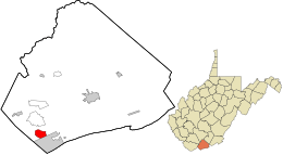 Location in Mercer County and the state of West Virginia. | |
| Coordinates: 37°16′51″N 81°15′21″W / 37.28083°N 81.25583°WCoordinates: 37°16′51″N 81°15′21″W / 37.28083°N 81.25583°W | |
| Country | United States |
| State | West Virginia |
| County | Mercer |
| Area[1] | |
| • Total | 1.903 sq mi (4.93 km2) |
| • Land | 1.901 sq mi (4.92 km2) |
| • Water | 0.002 sq mi (0.005 km2) |
| Elevation | 2,405 ft (733 m) |
| Population (2010)[2] | |
| • Total | 1,197 |
| • Density | 630/sq mi (240/km2) |
| Time zone | Eastern (EST) (UTC-5) |
| • Summer (DST) | EDT (UTC-4) |
| Area code(s) | 304 & 681 |
| GNIS feature ID | 1554001[3] |
Brush Fork is a census-designated place (CDP) in Mercer County, West Virginia, United States. Brush Fork is 2 miles (3.2 km) northwest of Bluefield. As of the 2010 census, its population was 1,197.[2]
The community takes its name from nearby Brush Fork creek.[4]
References
- ↑ "US Gazetteer files: 2010, 2000, and 1990". United States Census Bureau. 2011-02-12. Retrieved 2011-04-23.
- 1 2 "American FactFinder". United States Census Bureau. Archived from the original on 2013-09-11. Retrieved 2011-05-14.
- ↑ U.S. Geological Survey Geographic Names Information System: Brush Fork, West Virginia
- ↑ Kenny, Hamill (1945). West Virginia Place Names: Their Origin and Meaning, Including the Nomenclature of the Streams and Mountains. Piedmont, WV: The Place Name Press. p. 133.
Municipalities and communities of Mercer County, West Virginia, United States | ||
|---|---|---|
| Cities | 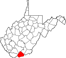 | |
| Towns | ||
| CDPs | ||
| Other communities |
| |
| Ghost town | ||
| Footnotes | ‡This populated place also has portions in an adjacent county or counties | |
This article is issued from Wikipedia - version of the 11/9/2016. The text is available under the Creative Commons Attribution/Share Alike but additional terms may apply for the media files.